

Mountains should be the western end of the Dachaidan Lake. At that time, the
drainage center of eastern Tata River and the weastern Yuka River were also a part
of the Dachaidan Lake. Later on, due to intensified neotectonic movements, the
mountainous areas around the Dachaidan Basin were further uplifted, leading to the
relative subsidence of the Dachaidan Basin. Morevoer, the uplift of Dayushan
Mountain in the west blocked the replenishment of surface water and groundwater
of the Yuka River to the Dachaidan Lake; the uplift of the Lvliang Mountain in the
east blocked the surface water connection of the Tataleng River, which makes
Dachaidan a relatively independent sub-basin. Thereafter, the center of the
Dachaidan Lake also moved from the northwest to the southeast, while the rivers in
the northern mountainous areas underwent changes with the uneven subsidence of
mountainous areas and the basin. This leads to the current topography of the
Dachaidan Basin and the current shape of the Dachaidan Lake.
– Water yield property of aquifer group
According to the hydrogeological survey and pumping test in boreholes, the
water-rich areas in the Baligou alluvial-pluvial fan are mainly distributed along the
modern riverbed and the ancient river channel, while the water-bearing capacity is
gradually weakened on both sides. The alluvial-pluvial fan can be divided into
zones based on groundwater distribution and abundance characteristics.
Levels of groundwater abundance
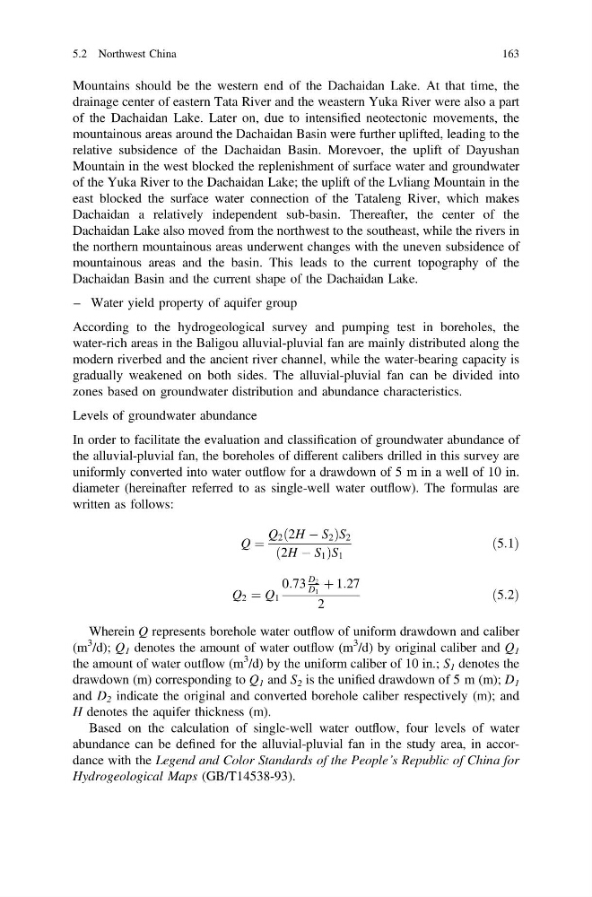
In order to facilitate the evaluation and classification of groundwater abundance of
the alluvial-pluvial fan, the boreholes of different calibers drilled in this survey are
uniformly converted into water outflow for a drawdown of 5 m in a well of 10 in.
diameter (hereinafter referred to as single-well water outflow). The formulas are
written as follows:
Q ¼
Q 2 ð2H À S 2 ÞS 2
ð2H À S 1 ÞS 1
ð5:1Þ
Q 2 ¼ Q 1
0:73
D 2
D 1
þ 1:27
2
ð5:2Þ
Wherein Q represents borehole water outflow of uniform drawdown and caliber
(m
3 /d); Q 1 denotes the amount of water outflow (m
3 /d) by original caliber and Q 1
the amount of water outflow (m
3 /d) by the uniform caliber of 10 in.; S 1 denotes the
drawdown (m) corresponding to Q 1 and S 2 is the unified drawdown of 5 m (m); D 1
and D 2 indicate the original and converted borehole caliber respectively (m); and
H denotes the aquifer thickness (m).
Based on the calculation of single-well water outflow, four levels of water
abundance can be defined for the alluvial-pluvial fan in the study area, in accordance with the Legend and Color Standards of the People’s Republic of China for
Hydrogeological Maps (GB/T14538-93).
5.2 Northwest China
163
drainage center of eastern Tata River and the weastern Yuka River were also a part
of the Dachaidan Lake. Later on, due to intensified neotectonic movements, the
mountainous areas around the Dachaidan Basin were further uplifted, leading to the
relative subsidence of the Dachaidan Basin. Morevoer, the uplift of Dayushan
Mountain in the west blocked the replenishment of surface water and groundwater
of the Yuka River to the Dachaidan Lake; the uplift of the Lvliang Mountain in the
east blocked the surface water connection of the Tataleng River, which makes
Dachaidan a relatively independent sub-basin. Thereafter, the center of the
Dachaidan Lake also moved from the northwest to the southeast, while the rivers in
the northern mountainous areas underwent changes with the uneven subsidence of
mountainous areas and the basin. This leads to the current topography of the
Dachaidan Basin and the current shape of the Dachaidan Lake.
– Water yield property of aquifer group
According to the hydrogeological survey and pumping test in boreholes, the
water-rich areas in the Baligou alluvial-pluvial fan are mainly distributed along the
modern riverbed and the ancient river channel, while the water-bearing capacity is
gradually weakened on both sides. The alluvial-pluvial fan can be divided into
zones based on groundwater distribution and abundance characteristics.
Levels of groundwater abundance
In order to facilitate the evaluation and classification of groundwater abundance of
the alluvial-pluvial fan, the boreholes of different calibers drilled in this survey are
uniformly converted into water outflow for a drawdown of 5 m in a well of 10 in.
diameter (hereinafter referred to as single-well water outflow). The formulas are
written as follows:
Q ¼
Q 2 ð2H À S 2 ÞS 2
ð2H À S 1 ÞS 1
ð5:1Þ
Q 2 ¼ Q 1
0:73
D 2
D 1
þ 1:27
2
ð5:2Þ
Wherein Q represents borehole water outflow of uniform drawdown and caliber
(m
3 /d); Q 1 denotes the amount of water outflow (m
3 /d) by original caliber and Q 1
the amount of water outflow (m
3 /d) by the uniform caliber of 10 in.; S 1 denotes the
drawdown (m) corresponding to Q 1 and S 2 is the unified drawdown of 5 m (m); D 1
and D 2 indicate the original and converted borehole caliber respectively (m); and
H denotes the aquifer thickness (m).
Based on the calculation of single-well water outflow, four levels of water
abundance can be defined for the alluvial-pluvial fan in the study area, in accordance with the Legend and Color Standards of the People’s Republic of China for
Hydrogeological Maps (GB/T14538-93).
5.2 Northwest China
163