

CN ¼
A 1 CN 1 þ A 2 CN 2 þ A 3 CN 3 þ . . . . . . A n CN n
ð
Þ
A 1 þ A 2 þ A 3 þ : . . . . . . A n
ð
Þ
ð3:7Þ
The whole curve number (CN) (A 1 , A 2 , A 3 . . . A n ) represents the overall area of
all LULC existing in the basin. A 1 to A n is the area of different LULC classes, and
CN 1 to CN n represent the corresponding CN of LULC classes, where CN is
the weighted curve number; CN 1 is the curve number from 1 to any number N; A 1
is the area with curve number CN 1 ; and A represents the entire basin. To compute the
surface runoff depth in the basin, the hydrologic equations (Eqs. 3.4, 3.5, 3.6, 3.7)
are used to determine the rate of rainfall.
Assessment of Rainfall–Runoff Using the SCS CN Method
Surface runoff is computed by selecting an extreme single rainfall event that
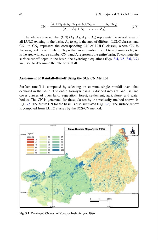
occurred in the basin. The entire Koraiyar basin is divided into six land use/land
cover classes of open land, vegetation, forest, settlement, agriculture, and water
bodies. The CN is generated for these classes by the reclassify method shown in
Fig. 3.5. The future CN for the basin is also simulated (Fig. 3.6). The surface runoff
is computed from LULC classes by the SCS-CN method.
Fig. 3.5 Developed CN map of Koraiyar basin for year 1986
62
S. Natarajan and N. Radhakrishnan
A 1 CN 1 þ A 2 CN 2 þ A 3 CN 3 þ . . . . . . A n CN n
ð
Þ
A 1 þ A 2 þ A 3 þ : . . . . . . A n
ð
Þ
ð3:7Þ
The whole curve number (CN) (A 1 , A 2 , A 3 . . . A n ) represents the overall area of
all LULC existing in the basin. A 1 to A n is the area of different LULC classes, and
CN 1 to CN n represent the corresponding CN of LULC classes, where CN is
the weighted curve number; CN 1 is the curve number from 1 to any number N; A 1
is the area with curve number CN 1 ; and A represents the entire basin. To compute the
surface runoff depth in the basin, the hydrologic equations (Eqs. 3.4, 3.5, 3.6, 3.7)
are used to determine the rate of rainfall.
Assessment of Rainfall–Runoff Using the SCS CN Method
Surface runoff is computed by selecting an extreme single rainfall event that
occurred in the basin. The entire Koraiyar basin is divided into six land use/land
cover classes of open land, vegetation, forest, settlement, agriculture, and water
bodies. The CN is generated for these classes by the reclassify method shown in
Fig. 3.5. The future CN for the basin is also simulated (Fig. 3.6). The surface runoff
is computed from LULC classes by the SCS-CN method.
Fig. 3.5 Developed CN map of Koraiyar basin for year 1986
62
S. Natarajan and N. Radhakrishnan