

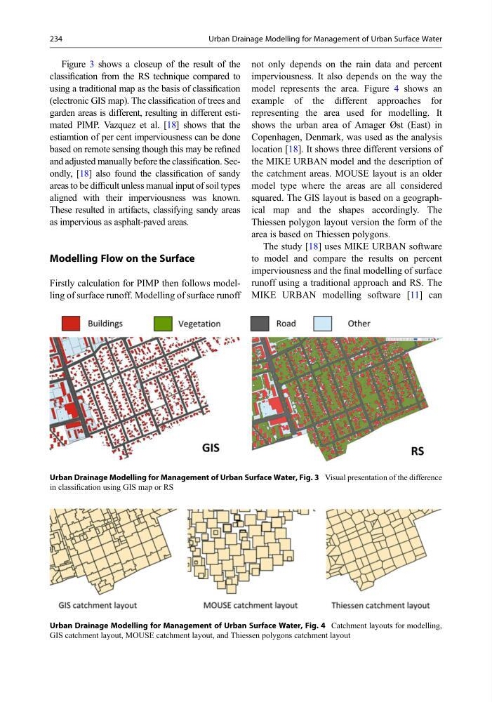
Figure 3 shows a closeup of the result of the
classification from the RS technique compared to
using a traditional map as the basis of classification
(electronic GIS map). The classification of trees and
garden areas is different, resulting in different estimated PIMP. Vazquez et al. [18] shows that the
estiamtion of per cent imperviousness can be done
based on remote sensing though this may be refined
and adjusted manually before the classification. Secondly, [18] also found the classification of sandy
areas to be difficult unless manual input of soil types
aligned with their imperviousness was known.
These resulted in artifacts, classifying sandy areas
as impervious as asphalt-paved areas.
Modelling Flow on the Surface
Firstly calculation for PIMP then follows modelling of surface runoff. Modelling of surface runoff
not only depends on the rain data and percent
imperviousness. It also depends on the way the
model represents the area. Figure 4 shows an
example of the different approaches for
representing the area used for modelling. It
shows the urban area of Amager Øst (East) in
Copenhagen, Denmark, was used as the analysis
location [18]. It shows three different versions of
the MIKE URBAN model and the description of
the catchment areas. MOUSE layout is an older
model type where the areas are all considered
squared. The GIS layout is based on a geographical map and the shapes accordingly. The
Thiessen polygon layout version the form of the
area is based on Thiessen polygons.
The study [18] uses MIKE URBAN software
to model and compare the results on percent
imperviousness and the final modelling of surface
runoff using a traditional approach and RS. The
MIKE URBAN modelling software [11] can
Urban Drainage Modelling for Management of Urban Surface Water, Fig. 3 Visual presentation of the difference
in classification using GIS map or RS
Urban Drainage Modelling for Management of Urban Surface Water, Fig. 4 Catchment layouts for modelling,
GIS catchment layout, MOUSE catchment layout, and Thiessen polygons catchment layout
234
Urban Drainage Modelling for Management of Urban Surface Water
classification from the RS technique compared to
using a traditional map as the basis of classification
(electronic GIS map). The classification of trees and
garden areas is different, resulting in different estimated PIMP. Vazquez et al. [18] shows that the
estiamtion of per cent imperviousness can be done
based on remote sensing though this may be refined
and adjusted manually before the classification. Secondly, [18] also found the classification of sandy
areas to be difficult unless manual input of soil types
aligned with their imperviousness was known.
These resulted in artifacts, classifying sandy areas
as impervious as asphalt-paved areas.
Modelling Flow on the Surface
Firstly calculation for PIMP then follows modelling of surface runoff. Modelling of surface runoff
not only depends on the rain data and percent
imperviousness. It also depends on the way the
model represents the area. Figure 4 shows an
example of the different approaches for
representing the area used for modelling. It
shows the urban area of Amager Øst (East) in
Copenhagen, Denmark, was used as the analysis
location [18]. It shows three different versions of
the MIKE URBAN model and the description of
the catchment areas. MOUSE layout is an older
model type where the areas are all considered
squared. The GIS layout is based on a geographical map and the shapes accordingly. The
Thiessen polygon layout version the form of the
area is based on Thiessen polygons.
The study [18] uses MIKE URBAN software
to model and compare the results on percent
imperviousness and the final modelling of surface
runoff using a traditional approach and RS. The
MIKE URBAN modelling software [11] can
Urban Drainage Modelling for Management of Urban Surface Water, Fig. 3 Visual presentation of the difference
in classification using GIS map or RS
Urban Drainage Modelling for Management of Urban Surface Water, Fig. 4 Catchment layouts for modelling,
GIS catchment layout, MOUSE catchment layout, and Thiessen polygons catchment layout
234
Urban Drainage Modelling for Management of Urban Surface Water