

sensing (RS), has been the subject of engineering
efforts. This approach offers an alternative for
mapping urban areas, which not saves time and
reduces costs but also reduces the dependency on
manual visual interpretation.
The use of RS for classification and thereby
calculation of the percent imperviousness based
on same started at the beginning of the twenty-first
century [13], and the technology has steadily
advanced since with the development of new
sensors.
The RS of urban impervious surfaces demands
a high spatial and multispectral resolution to be
able to discern features in such complex environments [13]. The minimum spatial resolution
required for urban environments is half the diameter of the smallest object of interest [13,
14]. Impervious features such as buildings
(perimeter, area, height, and property line) and
roads (width) are generally detectable with a
minimum spatial resolution of 0.25–0.5 m [13,
14]. For lower spatial resolutions, GIS data can
be integrated with satellite or airborne images to
minimize misclassifications and improve
accuracy [15].
Many different image classification methods
can be used to automatically categorize the pixels
of the RS images into land use types [16]. The
approach used to classify an urban land cover
depends on the nature of the analyzed data, the
available computational resources, and the
intended application of the data classified [17].
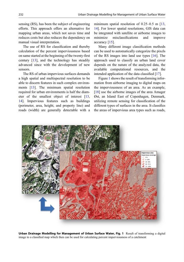
Figure 1 shows the result of transforming information from airborne imaging to digital maps on
the imperviousness of an area. As an example,
[18] use the airborne images of the area Amager
Øst, an Island East of Copenhagen, Denmark,
utilizing remote sensing for classification of the
different types of surfaces in the area. It classifies
the areas of impervious area types such as roads,
Urban Drainage Modelling for Management of Urban Surface Water, Fig. 1 Result of transforming a digital
image to a classified map which then can be used for calculating percent imperviousness of a catchment
232
Urban Drainage Modelling for Management of Urban Surface Water
efforts. This approach offers an alternative for
mapping urban areas, which not saves time and
reduces costs but also reduces the dependency on
manual visual interpretation.
The use of RS for classification and thereby
calculation of the percent imperviousness based
on same started at the beginning of the twenty-first
century [13], and the technology has steadily
advanced since with the development of new
sensors.
The RS of urban impervious surfaces demands
a high spatial and multispectral resolution to be
able to discern features in such complex environments [13]. The minimum spatial resolution
required for urban environments is half the diameter of the smallest object of interest [13,
14]. Impervious features such as buildings
(perimeter, area, height, and property line) and
roads (width) are generally detectable with a
minimum spatial resolution of 0.25–0.5 m [13,
14]. For lower spatial resolutions, GIS data can
be integrated with satellite or airborne images to
minimize misclassifications and improve
accuracy [15].
Many different image classification methods
can be used to automatically categorize the pixels
of the RS images into land use types [16]. The
approach used to classify an urban land cover
depends on the nature of the analyzed data, the
available computational resources, and the
intended application of the data classified [17].
Figure 1 shows the result of transforming information from airborne imaging to digital maps on
the imperviousness of an area. As an example,
[18] use the airborne images of the area Amager
Øst, an Island East of Copenhagen, Denmark,
utilizing remote sensing for classification of the
different types of surfaces in the area. It classifies
the areas of impervious area types such as roads,
Urban Drainage Modelling for Management of Urban Surface Water, Fig. 1 Result of transforming a digital
image to a classified map which then can be used for calculating percent imperviousness of a catchment
232
Urban Drainage Modelling for Management of Urban Surface Water