

130
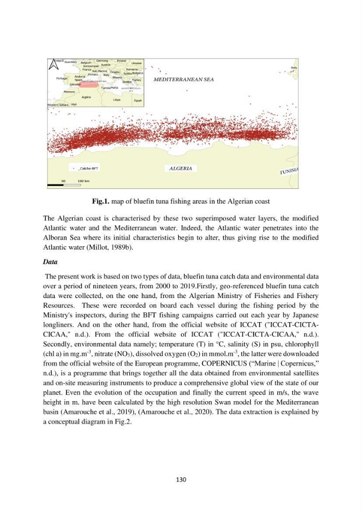
Fig.1. map of bluefin tuna fishing areas in the Algerian coast
The Algerian coast is characterised by these two superimposed water layers, the modified
Atlantic water and the Mediterranean water. Indeed, the Atlantic water penetrates into the
Alboran Sea where its initial characteristics begin to alter, thus giving rise to the modified
Atlantic water (Millot, 1989b).
Data
The present work is based on two types of data, bluefin tuna catch data and environmental data
over a period of nineteen years, from 2000 to 2019.Firstly, geo-referenced bluefin tuna catch
data were collected, on the one hand, from the Algerian Ministry of Fisheries and Fishery
Resources. These were recorded on board each vessel during the fishing period by the
Ministry's inspectors, during the BFT fishing campaigns carried out each year by Japanese
longliners. And on the other hand, from the official website of ICCAT ("ICCAT-CICTACICAA," n.d.). From the official website of ICCAT ("ICCAT-CICTA-CICAA," n.d.).
Secondly, environmental data namely; temperature (T) in °C, salinity (S) in psu, chlorophyll
(chl a) in mg.m
-3 , nitrate (NO3), dissolved oxygen (O2) in mmol.m
-3 , the latter were downloaded
from the official website of the European programme, COPERNICUS (“Marine | Copernicus,”
n.d.), is a programme that brings together all the data obtained from environmental satellites
and on-site measuring instruments to produce a comprehensive global view of the state of our
planet. Even the evolution of the occupation and finally the current speed in m/s, the wave
height in m. have been calculated by the high resolution Swan model for the Mediterranean
basin (Amarouche et al., 2019), (Amarouche et al., 2020). The data extraction is explained by
a conceptual diagram in Fig.2.
Fig.1. map of bluefin tuna fishing areas in the Algerian coast
The Algerian coast is characterised by these two superimposed water layers, the modified
Atlantic water and the Mediterranean water. Indeed, the Atlantic water penetrates into the
Alboran Sea where its initial characteristics begin to alter, thus giving rise to the modified
Atlantic water (Millot, 1989b).
Data
The present work is based on two types of data, bluefin tuna catch data and environmental data
over a period of nineteen years, from 2000 to 2019.Firstly, geo-referenced bluefin tuna catch
data were collected, on the one hand, from the Algerian Ministry of Fisheries and Fishery
Resources. These were recorded on board each vessel during the fishing period by the
Ministry's inspectors, during the BFT fishing campaigns carried out each year by Japanese
longliners. And on the other hand, from the official website of ICCAT ("ICCAT-CICTACICAA," n.d.). From the official website of ICCAT ("ICCAT-CICTA-CICAA," n.d.).
Secondly, environmental data namely; temperature (T) in °C, salinity (S) in psu, chlorophyll
(chl a) in mg.m
-3 , nitrate (NO3), dissolved oxygen (O2) in mmol.m
-3 , the latter were downloaded
from the official website of the European programme, COPERNICUS (“Marine | Copernicus,”
n.d.), is a programme that brings together all the data obtained from environmental satellites
and on-site measuring instruments to produce a comprehensive global view of the state of our
planet. Even the evolution of the occupation and finally the current speed in m/s, the wave
height in m. have been calculated by the high resolution Swan model for the Mediterranean
basin (Amarouche et al., 2019), (Amarouche et al., 2020). The data extraction is explained by
a conceptual diagram in Fig.2.