

350
M. Kejna et al.
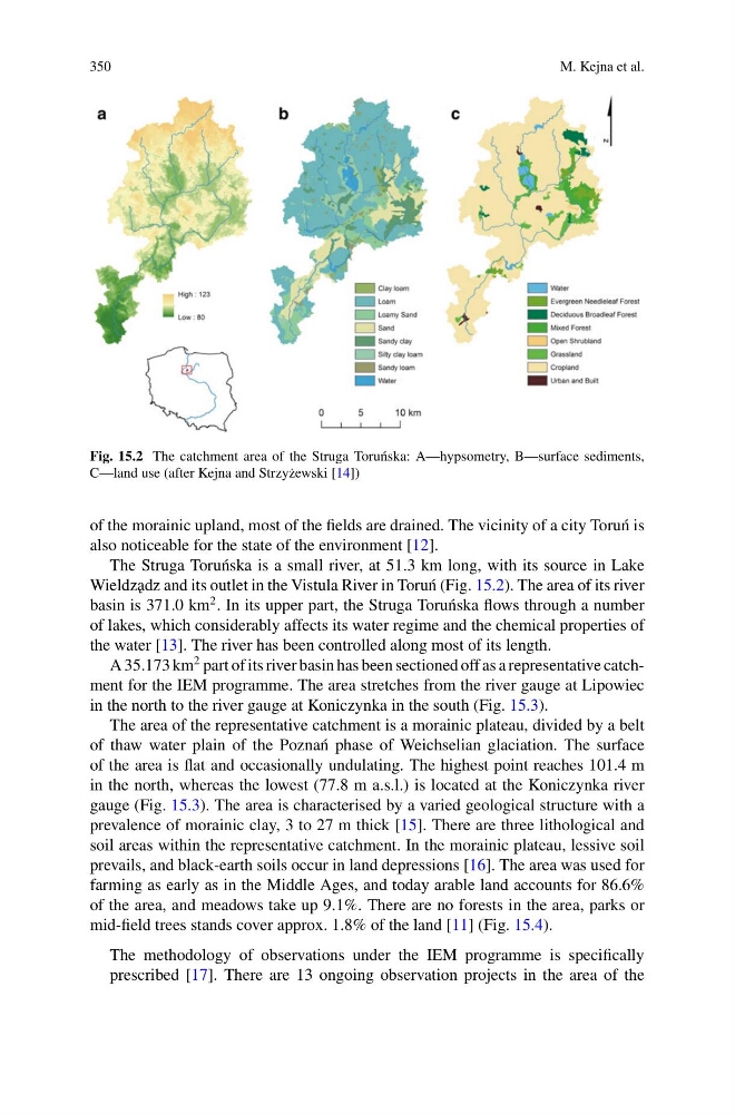
Fig. 15.2 The catchment area of the Struga Toru´ nska: A—hypsometry, B—surface sediments,
C—land use (after Kejna and Strzy˙ zewski [14])
of the morainic upland, most of the fields are drained. The vicinity of a city Toru´ n is
also noticeable for the state of the environment [12].
The Struga Toru´ nska is a small river, at 51.3 km long, with its source in Lake
Wieldz˛ adz and its outlet in the Vistula River in Toru´ n (Fig. 15.2). The area of its river
basin is 371.0 km
2 . In its upper part, the Struga Toru´ nska flows through a number
of lakes, which considerably affects its water regime and the chemical properties of
the water [13]. The river has been controlled along most of its length.
A 35.173 km
2 part of its river basin has been sectioned off as a representative catchment for the IEM programme. The area stretches from the river gauge at Lipowiec
in the north to the river gauge at Koniczynka in the south (Fig. 15.3).
The area of the representative catchment is a morainic plateau, divided by a belt
of thaw water plain of the Pozna´ n phase of Weichselian glaciation. The surface
of the area is flat and occasionally undulating. The highest point reaches 101.4 m
in the north, whereas the lowest (77.8 m a.s.l.) is located at the Koniczynka river
gauge (Fig. 15.3). The area is characterised by a varied geological structure with a
prevalence of morainic clay, 3 to 27 m thick [15]. There are three lithological and
soil areas within the representative catchment. In the morainic plateau, lessive soil
prevails, and black-earth soils occur in land depressions [16]. The area was used for
farming as early as in the Middle Ages, and today arable land accounts for 86.6%
of the area, and meadows take up 9.1%. There are no forests in the area, parks or
mid-field trees stands cover approx. 1.8% of the land [11] (Fig. 15.4).
The methodology of observations under the IEM programme is specifically
prescribed [17]. There are 13 ongoing observation projects in the area of the
M. Kejna et al.
Fig. 15.2 The catchment area of the Struga Toru´ nska: A—hypsometry, B—surface sediments,
C—land use (after Kejna and Strzy˙ zewski [14])
of the morainic upland, most of the fields are drained. The vicinity of a city Toru´ n is
also noticeable for the state of the environment [12].
The Struga Toru´ nska is a small river, at 51.3 km long, with its source in Lake
Wieldz˛ adz and its outlet in the Vistula River in Toru´ n (Fig. 15.2). The area of its river
basin is 371.0 km
2 . In its upper part, the Struga Toru´ nska flows through a number
of lakes, which considerably affects its water regime and the chemical properties of
the water [13]. The river has been controlled along most of its length.
A 35.173 km
2 part of its river basin has been sectioned off as a representative catchment for the IEM programme. The area stretches from the river gauge at Lipowiec
in the north to the river gauge at Koniczynka in the south (Fig. 15.3).
The area of the representative catchment is a morainic plateau, divided by a belt
of thaw water plain of the Pozna´ n phase of Weichselian glaciation. The surface
of the area is flat and occasionally undulating. The highest point reaches 101.4 m
in the north, whereas the lowest (77.8 m a.s.l.) is located at the Koniczynka river
gauge (Fig. 15.3). The area is characterised by a varied geological structure with a
prevalence of morainic clay, 3 to 27 m thick [15]. There are three lithological and
soil areas within the representative catchment. In the morainic plateau, lessive soil
prevails, and black-earth soils occur in land depressions [16]. The area was used for
farming as early as in the Middle Ages, and today arable land accounts for 86.6%
of the area, and meadows take up 9.1%. There are no forests in the area, parks or
mid-field trees stands cover approx. 1.8% of the land [11] (Fig. 15.4).
The methodology of observations under the IEM programme is specifically
prescribed [17]. There are 13 ongoing observation projects in the area of the