

2 Assessment of Water Resources in Poland
25
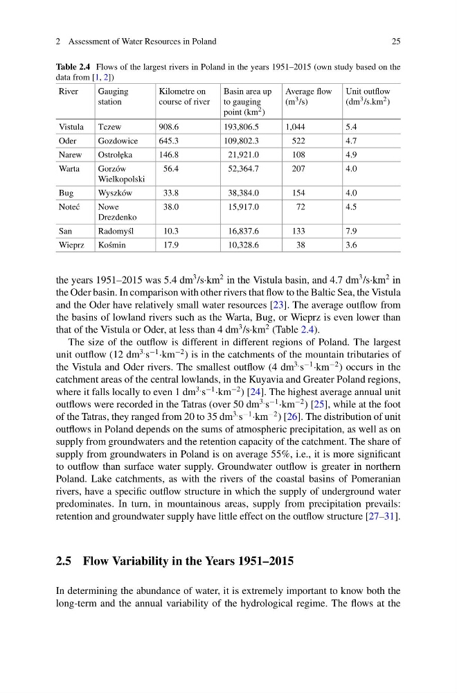
Table 2.4 Flows of the largest rivers in Poland in the years 1951–2015 (own study based on the
data from [1, 2])
River
Gauging
station
Kilometre on
course of river
Basin area up
to gauging
point (km 2 )
Average flow
(m 3 /s)
Unit outflow
(dm 3 /s.km 2 )
Vistula
Tczew
908.6
193,806.5
1,044
5.4
Oder
Gozdowice
645.3
109,802.3
522
4.7
Narew
Ostroł˛ eka
146.8
21,921.0
108
4.9
Warta
Gorzów
Wielkopolski
56.4
52,364.7
207
4.0
Bug
Wyszków
33.8
38,384.0
154
4.0
Note´ c
Nowe
Drezdenko
38.0
15,917.0
72
4.5
San
Radomy´ sl
10.3
16,837.6
133
7.9
Wieprz
Ko´ smin
17.9
10,328.6
38
3.6
the years 1951–2015 was 5.4 dm
3 /s·km
2 in the Vistula basin, and 4.7 dm
3 /s·km
2 in
the Oder basin. In comparison with other rivers that flow to the Baltic Sea, the Vistula
and the Oder have relatively small water resources [23]. The average outflow from
the basins of lowland rivers such as the Warta, Bug, or Wieprz is even lower than
that of the Vistula or Oder, at less than 4 dm
3 /s·km
2 (Table 2.4).
The size of the outflow is different in different regions of Poland. The largest
unit outflow (12 dm
3. s
−1 ·km
−2 ) is in the catchments of the mountain tributaries of
the Vistula and Oder rivers. The smallest outflow (4 dm
3. s
−1 ·km
−2 ) occurs in the
catchment areas of the central lowlands, in the Kuyavia and Greater Poland regions,
where it falls locally to even 1 dm
3. s
−1 ·km
−2 ) [24]. The highest average annual unit
outflows were recorded in the Tatras (over 50 dm
3. s
−1 ·km
−2 ) [25], while at the foot
of the Tatras, they ranged from 20 to 35 dm
3. s
−1 ·km
−2 ) [26]. The distribution of unit
outflows in Poland depends on the sums of atmospheric precipitation, as well as on
supply from groundwaters and the retention capacity of the catchment. The share of
supply from groundwaters in Poland is on average 55%, i.e., it is more significant
to outflow than surface water supply. Groundwater outflow is greater in northern
Poland. Lake catchments, as with the rivers of the coastal basins of Pomeranian
rivers, have a specific outflow structure in which the supply of underground water
predominates. In turn, in mountainous areas, supply from precipitation prevails:
retention and groundwater supply have little effect on the outflow structure [27–31].
2.5 Flow Variability in the Years 1951–2015
In determining the abundance of water, it is extremely important to know both the
long-term and the annual variability of the hydrological regime. The flows at the
25
Table 2.4 Flows of the largest rivers in Poland in the years 1951–2015 (own study based on the
data from [1, 2])
River
Gauging
station
Kilometre on
course of river
Basin area up
to gauging
point (km 2 )
Average flow
(m 3 /s)
Unit outflow
(dm 3 /s.km 2 )
Vistula
Tczew
908.6
193,806.5
1,044
5.4
Oder
Gozdowice
645.3
109,802.3
522
4.7
Narew
Ostroł˛ eka
146.8
21,921.0
108
4.9
Warta
Gorzów
Wielkopolski
56.4
52,364.7
207
4.0
Bug
Wyszków
33.8
38,384.0
154
4.0
Note´ c
Nowe
Drezdenko
38.0
15,917.0
72
4.5
San
Radomy´ sl
10.3
16,837.6
133
7.9
Wieprz
Ko´ smin
17.9
10,328.6
38
3.6
the years 1951–2015 was 5.4 dm
3 /s·km
2 in the Vistula basin, and 4.7 dm
3 /s·km
2 in
the Oder basin. In comparison with other rivers that flow to the Baltic Sea, the Vistula
and the Oder have relatively small water resources [23]. The average outflow from
the basins of lowland rivers such as the Warta, Bug, or Wieprz is even lower than
that of the Vistula or Oder, at less than 4 dm
3 /s·km
2 (Table 2.4).
The size of the outflow is different in different regions of Poland. The largest
unit outflow (12 dm
3. s
−1 ·km
−2 ) is in the catchments of the mountain tributaries of
the Vistula and Oder rivers. The smallest outflow (4 dm
3. s
−1 ·km
−2 ) occurs in the
catchment areas of the central lowlands, in the Kuyavia and Greater Poland regions,
where it falls locally to even 1 dm
3. s
−1 ·km
−2 ) [24]. The highest average annual unit
outflows were recorded in the Tatras (over 50 dm
3. s
−1 ·km
−2 ) [25], while at the foot
of the Tatras, they ranged from 20 to 35 dm
3. s
−1 ·km
−2 ) [26]. The distribution of unit
outflows in Poland depends on the sums of atmospheric precipitation, as well as on
supply from groundwaters and the retention capacity of the catchment. The share of
supply from groundwaters in Poland is on average 55%, i.e., it is more significant
to outflow than surface water supply. Groundwater outflow is greater in northern
Poland. Lake catchments, as with the rivers of the coastal basins of Pomeranian
rivers, have a specific outflow structure in which the supply of underground water
predominates. In turn, in mountainous areas, supply from precipitation prevails:
retention and groundwater supply have little effect on the outflow structure [27–31].
2.5 Flow Variability in the Years 1951–2015
In determining the abundance of water, it is extremely important to know both the
long-term and the annual variability of the hydrological regime. The flows at the