

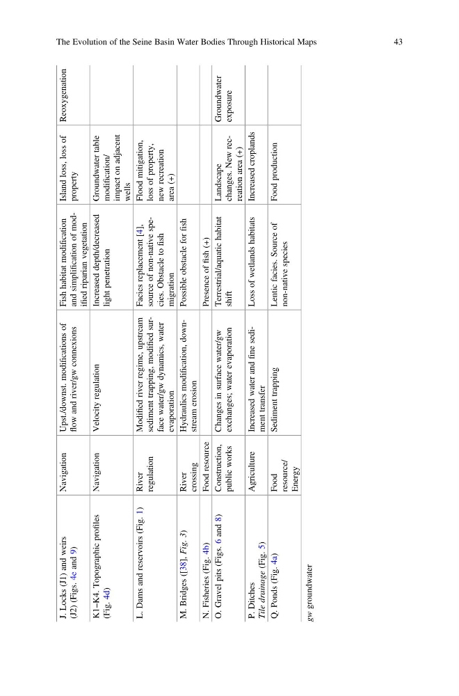
J. Locks (J1) and weirs
(J2) (Figs. 4e and 9)
Navigation
Upst./downst. modifications of
flow and river/gw connexions
Fish habitat modification
and simplification of modified riparian vegetation
Island loss, loss of
property
Reoxygenation
K1–K4. Topographic profiles
(Fig. 4d)
Navigation
Velocity regulation
Increased depth/decreased
light penetration
Groundwater table
modification/
impact on adjacent
wells
L. Dams and reservoirs (Fig. 1)
River
regulation
Modified river regime, upstream
sediment trapping, modified surface water/gw dynamics, water
evaporation
Facies replacement [4],
source of non-native species. Obstacle to
fish
migration
Flood mitigation,
loss of property,
new recreation
area (+)
M. Bridges ([38], Fig. 3)
River
crossing
Hydraulics modification, downstream erosion
Possible obstacle for
fish
N. Fisheries (Fig. 4b)
Food resource
Presence of
fish (+)
O. Gravel pits (Figs. 6 and 8)
Construction,
public works
Changes in surface water/gw
exchanges; water evaporation
Terrestrial/aquatic habitat
shift
Landscape
changes. New recreation area (+)
Groundwater
exposure
P. Ditches
Tile drainage
(Fig. 5)
Agriculture
Increased water and
fine sediment transfer
Loss of wetlands habitats
Increased croplands
Q. Ponds (Fig. 4a)
Food
resource/
Energy
Sediment trapping
Lentic facies. Source of
non-native species
Food production
gw
groundwater
The Evolution of the Seine Basin Water Bodies Through Historical Maps
43
(J2) (Figs. 4e and 9)
Navigation
Upst./downst. modifications of
flow and river/gw connexions
Fish habitat modification
and simplification of modified riparian vegetation
Island loss, loss of
property
Reoxygenation
K1–K4. Topographic profiles
(Fig. 4d)
Navigation
Velocity regulation
Increased depth/decreased
light penetration
Groundwater table
modification/
impact on adjacent
wells
L. Dams and reservoirs (Fig. 1)
River
regulation
Modified river regime, upstream
sediment trapping, modified surface water/gw dynamics, water
evaporation
Facies replacement [4],
source of non-native species. Obstacle to
fish
migration
Flood mitigation,
loss of property,
new recreation
area (+)
M. Bridges ([38], Fig. 3)
River
crossing
Hydraulics modification, downstream erosion
Possible obstacle for
fish
N. Fisheries (Fig. 4b)
Food resource
Presence of
fish (+)
O. Gravel pits (Figs. 6 and 8)
Construction,
public works
Changes in surface water/gw
exchanges; water evaporation
Terrestrial/aquatic habitat
shift
Landscape
changes. New recreation area (+)
Groundwater
exposure
P. Ditches
Tile drainage
(Fig. 5)
Agriculture
Increased water and
fine sediment transfer
Loss of wetlands habitats
Increased croplands
Q. Ponds (Fig. 4a)
Food
resource/
Energy
Sediment trapping
Lentic facies. Source of
non-native species
Food production
gw
groundwater
The Evolution of the Seine Basin Water Bodies Through Historical Maps
43