

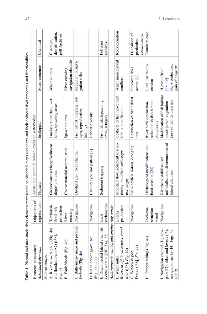
Table 1
Natural and man-made river elements represented on historical maps and charts and their deduced river properties and functionalities
Elements represented
Associated elements
Objectives of
representation
Actual and potential consequences on waterbodies
Physical
Ecological
Socio-economic
Chemical
Natural entities
A. River network (A1) (Fig. 4a)
and
flooded area (A2) ([38],
Fig. 9)
Territorial/
flood risk
protection
Groundwater recharge/sediment
deposition area
Land-river interface, wetlands, spawning areas
Water sources
C storage,
denitrification,
poll Archives
B. Fords/shoals (Fig. 4c)
River
crossing
Coarse material accumulation
Spawning area
River crossing,
navigation obstacle
C. Bathymetric maps and profiles
Isobaths
(Fig. 4e)
Navigation
Dredged area, river channel
Fish habitat mapping (refuges, reproduction,
feeding)
Reduction of navigation risks
D. Island and/or gravel bar
(Fig. 4b, c, e)
Navigation
Channel type and pattern [2]
Habitat diversity
E. Disconnected lateral channels
Lentic waters
([38], Fig. 21)
Land
reclamation
Sediment trapping
Fish habitats (spawning
areas, refuges)
Pollutant
archives
Anthropogenic entities and engineering works
F. Water mills
River cut-off, local bypass, canal,
weir
([38], Fig. 12)
Energy
production
Modified
flow, sediment discontinuity, modified surface/gw
exchanges
Obstacle to
fish movement
habitat modification
Water management
conflicts
Reoxygenation
G. Waterway port
Docks ([38], Fig. 11)
Navigation
Bank artificialisation, dredging
Destruction of
fish habitat
area
Improved river
access (+)
Deposition of
particulate
contaminants
H. Timber rafting (Fig. 4a)
Fuel/construction
wood
Hydrological modifications and
bank erosion [24]
River bank destruction,
reduction in
fish habitat
complexity
Land loss due to
erosion
Tannin release
I. Navigation channel (I1), towpath (I2), dikes and levees (I3),
navigation marks (I4) (Figs. 4c
and 9)
Navigation
Riverbank stabilisation/
artificialisation, disconnection of
lateral channels
Modification of
fish habitat
area/riparian vegetation
Loss of habitat diversity
“Levee effect”
[48, 49]
Bank protection,
gain of property
42
L. Lestel et al.
Natural and man-made river elements represented on historical maps and charts and their deduced river properties and functionalities
Elements represented
Associated elements
Objectives of
representation
Actual and potential consequences on waterbodies
Physical
Ecological
Socio-economic
Chemical
Natural entities
A. River network (A1) (Fig. 4a)
and
flooded area (A2) ([38],
Fig. 9)
Territorial/
flood risk
protection
Groundwater recharge/sediment
deposition area
Land-river interface, wetlands, spawning areas
Water sources
C storage,
denitrification,
poll Archives
B. Fords/shoals (Fig. 4c)
River
crossing
Coarse material accumulation
Spawning area
River crossing,
navigation obstacle
C. Bathymetric maps and profiles
Isobaths
(Fig. 4e)
Navigation
Dredged area, river channel
Fish habitat mapping (refuges, reproduction,
feeding)
Reduction of navigation risks
D. Island and/or gravel bar
(Fig. 4b, c, e)
Navigation
Channel type and pattern [2]
Habitat diversity
E. Disconnected lateral channels
Lentic waters
([38], Fig. 21)
Land
reclamation
Sediment trapping
Fish habitats (spawning
areas, refuges)
Pollutant
archives
Anthropogenic entities and engineering works
F. Water mills
River cut-off, local bypass, canal,
weir
([38], Fig. 12)
Energy
production
Modified
flow, sediment discontinuity, modified surface/gw
exchanges
Obstacle to
fish movement
habitat modification
Water management
conflicts
Reoxygenation
G. Waterway port
Docks ([38], Fig. 11)
Navigation
Bank artificialisation, dredging
Destruction of
fish habitat
area
Improved river
access (+)
Deposition of
particulate
contaminants
H. Timber rafting (Fig. 4a)
Fuel/construction
wood
Hydrological modifications and
bank erosion [24]
River bank destruction,
reduction in
fish habitat
complexity
Land loss due to
erosion
Tannin release
I. Navigation channel (I1), towpath (I2), dikes and levees (I3),
navigation marks (I4) (Figs. 4c
and 9)
Navigation
Riverbank stabilisation/
artificialisation, disconnection of
lateral channels
Modification of
fish habitat
area/riparian vegetation
Loss of habitat diversity
“Levee effect”
[48, 49]
Bank protection,
gain of property
42
L. Lestel et al.