

This again highlights the importance of a multidisciplinary approach to evaluate
the global environmental risk in aquatic ecosystems. Indeed, a comprehensive and
efficient ERA must jointly evaluate a site’s contamination (i.e. level of contaminants
in the environment) and pollution status (i.e. including the incidence and the severity
of the biological impacts of the contamination) [2, 64].
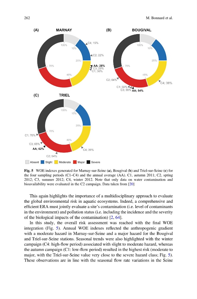
In this study, the overall risk assessment was reached with the final WOE
integration (Fig. 5). Annual WOE indexes reflected the anthropogenic gradient
with a moderate hazard in Marnay-sur-Seine and a major hazard for the Bougival
and Triel-sur-Seine stations. Seasonal trends were also highlighted with the winter
campaign (C4: high-flow period) associated with slight to moderate hazard, whereas
the autumn campaign (C1: low-flow period) resulted in the highest risk (moderate to
major, with the Triel-sur-Seine value very close to the severe hazard class; Fig. 5).
These observations are in line with the seasonal flow rate variations in the Seine
Absent
Slight
Moderate
Major
Severe
MARNAY
100%
10%
25%
45%
70%
C1; 30%
C2; 22%
C3; 29%
AA; 28%
C4; 15%
(A)
BOUGIVAL
100%
10%
25%
45%
70%
C1; 56%
C2; 64%
C3; 55%
C4; 38%
AA; 54%
(B)
TRIEL
100%
10%
25%
45%
70%
C1; 70%
C2; 54%
C3; 65%
C4; 39%
AA; 62%
(C)
Fig. 5 WOE indexes generated for Marnay-sur-Seine (a), Bougival (b) and Triel-sur-Seine (c) for
the four sampling periods (C1–C4) and the annual average (AA). C1, autumn 2011; C2, spring
2012; C3, summer 2012; C4, winter 2012. Note that only data on water contamination and
bioavailability were evaluated in the C2 campaign. Data taken from [20]
262
M. Bonnard et al.
the global environmental risk in aquatic ecosystems. Indeed, a comprehensive and
efficient ERA must jointly evaluate a site’s contamination (i.e. level of contaminants
in the environment) and pollution status (i.e. including the incidence and the severity
of the biological impacts of the contamination) [2, 64].
In this study, the overall risk assessment was reached with the final WOE
integration (Fig. 5). Annual WOE indexes reflected the anthropogenic gradient
with a moderate hazard in Marnay-sur-Seine and a major hazard for the Bougival
and Triel-sur-Seine stations. Seasonal trends were also highlighted with the winter
campaign (C4: high-flow period) associated with slight to moderate hazard, whereas
the autumn campaign (C1: low-flow period) resulted in the highest risk (moderate to
major, with the Triel-sur-Seine value very close to the severe hazard class; Fig. 5).
These observations are in line with the seasonal flow rate variations in the Seine
Absent
Slight
Moderate
Major
Severe
MARNAY
100%
10%
25%
45%
70%
C1; 30%
C2; 22%
C3; 29%
AA; 28%
C4; 15%
(A)
BOUGIVAL
100%
10%
25%
45%
70%
C1; 56%
C2; 64%
C3; 55%
C4; 38%
AA; 54%
(B)
TRIEL
100%
10%
25%
45%
70%
C1; 70%
C2; 54%
C3; 65%
C4; 39%
AA; 62%
(C)
Fig. 5 WOE indexes generated for Marnay-sur-Seine (a), Bougival (b) and Triel-sur-Seine (c) for
the four sampling periods (C1–C4) and the annual average (AA). C1, autumn 2011; C2, spring
2012; C3, summer 2012; C4, winter 2012. Note that only data on water contamination and
bioavailability were evaluated in the C2 campaign. Data taken from [20]
262
M. Bonnard et al.