

underground and surface water compartments over the Vesle basin. Again, we only
focussed on atrazine and DEA. From a modelling standpoint, this watershed offers
advantages such as relatively simple geological and hydrogeological configurations
and spatial homogeneity in soil properties and agricultural practices.
To interface STICS and the MODCOU-NEWSAM hydrogeological model, the
code was integrated into a computing structure [30, 51–53], allowing it to be used in
a broad spatial manner according to a bottom-up approach [54]. Consequently, this
procedure integrates the variability of inputs in space and time (soil types, climate,
agro-system management).
It therefore requires three kinds of input: (1) climate data from the SAFRAN
atmospheric analysis system [55, 56], (2) soil data at the 1:1000000 scale [57] for
which parameters are estimated through the use of pedo-transfer functions [58–61]
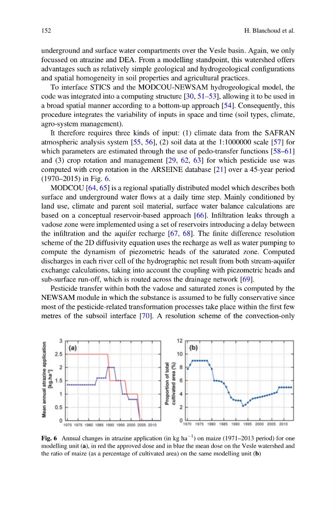
and (3) crop rotation and management [29, 62, 63] for which pesticide use was
computed with crop rotation in the ARSEINE database [21] over a 45-year period
(1970–2015) in Fig. 6.
MODCOU [64, 65] is a regional spatially distributed model which describes both
surface and underground water flows at a daily time step. Mainly conditioned by
land use, climate and parent soil material, surface water balance calculations are
based on a conceptual reservoir-based approach [66]. Infiltration leaks through a
vadose zone were implemented using a set of reservoirs introducing a delay between
the infiltration and the aquifer recharge [67, 68]. The finite difference resolution
scheme of the 2D diffusivity equation uses the recharge as well as water pumping to
compute the dynamism of piezometric heads of the saturated zone. Computed
discharges in each river cell of the hydrographic net result from both stream-aquifer
exchange calculations, taking into account the coupling with piezometric heads and
sub-surface run-off, which is routed across the drainage network [69].
Pesticide transfer within both the vadose and saturated zones is computed by the
NEWSAM module in which the substance is assumed to be fully conservative since
most of the pesticide-related transformation processes take place within the first few
metres of the subsoil interface [70]. A resolution scheme of the convection-only
Fig. 6 Annual changes in atrazine application (in kg ha
À1
) on maize (1971–2013 period) for one
modelling unit (a), in red the approved dose and in blue the mean dose on the Vesle watershed and
the ratio of maize (as a percentage of cultivated area) on the same modelling unit (b)
152
H. Blanchoud et al.
focussed on atrazine and DEA. From a modelling standpoint, this watershed offers
advantages such as relatively simple geological and hydrogeological configurations
and spatial homogeneity in soil properties and agricultural practices.
To interface STICS and the MODCOU-NEWSAM hydrogeological model, the
code was integrated into a computing structure [30, 51–53], allowing it to be used in
a broad spatial manner according to a bottom-up approach [54]. Consequently, this
procedure integrates the variability of inputs in space and time (soil types, climate,
agro-system management).
It therefore requires three kinds of input: (1) climate data from the SAFRAN
atmospheric analysis system [55, 56], (2) soil data at the 1:1000000 scale [57] for
which parameters are estimated through the use of pedo-transfer functions [58–61]
and (3) crop rotation and management [29, 62, 63] for which pesticide use was
computed with crop rotation in the ARSEINE database [21] over a 45-year period
(1970–2015) in Fig. 6.
MODCOU [64, 65] is a regional spatially distributed model which describes both
surface and underground water flows at a daily time step. Mainly conditioned by
land use, climate and parent soil material, surface water balance calculations are
based on a conceptual reservoir-based approach [66]. Infiltration leaks through a
vadose zone were implemented using a set of reservoirs introducing a delay between
the infiltration and the aquifer recharge [67, 68]. The finite difference resolution
scheme of the 2D diffusivity equation uses the recharge as well as water pumping to
compute the dynamism of piezometric heads of the saturated zone. Computed
discharges in each river cell of the hydrographic net result from both stream-aquifer
exchange calculations, taking into account the coupling with piezometric heads and
sub-surface run-off, which is routed across the drainage network [69].
Pesticide transfer within both the vadose and saturated zones is computed by the
NEWSAM module in which the substance is assumed to be fully conservative since
most of the pesticide-related transformation processes take place within the first few
metres of the subsoil interface [70]. A resolution scheme of the convection-only
Fig. 6 Annual changes in atrazine application (in kg ha
À1
) on maize (1971–2013 period) for one
modelling unit (a), in red the approved dose and in blue the mean dose on the Vesle watershed and
the ratio of maize (as a percentage of cultivated area) on the same modelling unit (b)
152
H. Blanchoud et al.