

ranges i.e. 200, 50 and 12 kHz (SDI 2017;
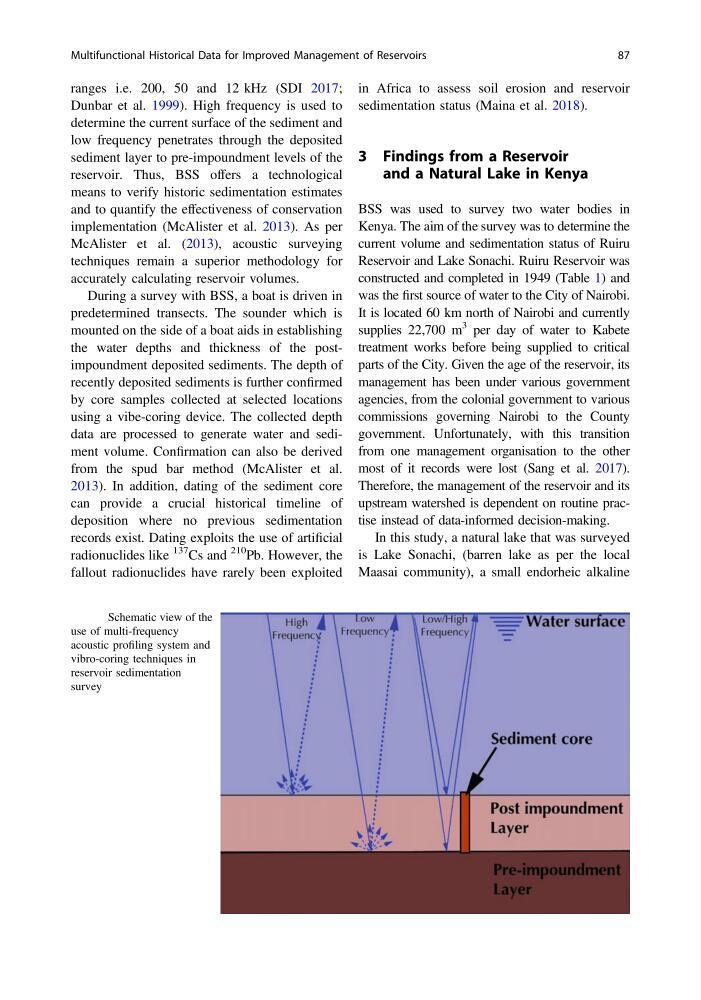
Dunbar et al. 1999). High frequency is used to
determine the current surface of the sediment and
low frequency penetrates through the deposited
sediment layer to pre-impoundment levels of the
reservoir. Thus, BSS offers a technological
means to verify historic sedimentation estimates
and to quantify the effectiveness of conservation
implementation (McAlister et al. 2013). As per
McAlister et al. (2013), acoustic surveying
techniques remain a superior methodology for
accurately calculating reservoir volumes.
During a survey with BSS, a boat is driven in
predetermined transects. The sounder which is
mounted on the side of a boat aids in establishing
the water depths and thickness of the postimpoundment deposited sediments. The depth of
recently deposited sediments is further confirmed
by core samples collected at selected locations
using a vibe-coring device. The collected depth
data are processed to generate water and sediment volume. Confirmation can also be derived
from the spud bar method (McAlister et al.
2013). In addition, dating of the sediment core
can provide a crucial historical timeline of
deposition where no previous sedimentation
records exist. Dating exploits the use of artificial
radionuclides like
137 Cs and
210 Pb. However, the
fallout radionuclides have rarely been exploited
in Africa to assess soil erosion and reservoir
sedimentation status (Maina et al. 2018).
3 Findings from a Reservoir
and a Natural Lake in Kenya
BSS was used to survey two water bodies in
Kenya. The aim of the survey was to determine the
current volume and sedimentation status of Ruiru
Reservoir and Lake Sonachi. Ruiru Reservoir was
constructed and completed in 1949 (Table 1) and
was the first source of water to the City of Nairobi.
It is located 60 km north of Nairobi and currently
supplies 22,700 m
3 per day of water to Kabete
treatment works before being supplied to critical
parts of the City. Given the age of the reservoir, its
management has been under various government
agencies, from the colonial government to various
commissions governing Nairobi to the County
government. Unfortunately, with this transition
from one management organisation to the other
most of it records were lost (Sang et al. 2017).
Therefore, the management of the reservoir and its
upstream watershed is dependent on routine practise instead of data-informed decision-making.
In this study, a natural lake that was surveyed
is Lake Sonachi, (barren lake as per the local
Maasai community), a small endorheic alkaline
Fig. 2 Schematic view of the
use of multi-frequency
acoustic profiling system and
vibro-coring techniques in
reservoir sedimentation
survey
Multifunctional Historical Data for Improved Management of Reservoirs
87
Dunbar et al. 1999). High frequency is used to
determine the current surface of the sediment and
low frequency penetrates through the deposited
sediment layer to pre-impoundment levels of the
reservoir. Thus, BSS offers a technological
means to verify historic sedimentation estimates
and to quantify the effectiveness of conservation
implementation (McAlister et al. 2013). As per
McAlister et al. (2013), acoustic surveying
techniques remain a superior methodology for
accurately calculating reservoir volumes.
During a survey with BSS, a boat is driven in
predetermined transects. The sounder which is
mounted on the side of a boat aids in establishing
the water depths and thickness of the postimpoundment deposited sediments. The depth of
recently deposited sediments is further confirmed
by core samples collected at selected locations
using a vibe-coring device. The collected depth
data are processed to generate water and sediment volume. Confirmation can also be derived
from the spud bar method (McAlister et al.
2013). In addition, dating of the sediment core
can provide a crucial historical timeline of
deposition where no previous sedimentation
records exist. Dating exploits the use of artificial
radionuclides like
137 Cs and
210 Pb. However, the
fallout radionuclides have rarely been exploited
in Africa to assess soil erosion and reservoir
sedimentation status (Maina et al. 2018).
3 Findings from a Reservoir
and a Natural Lake in Kenya
BSS was used to survey two water bodies in
Kenya. The aim of the survey was to determine the
current volume and sedimentation status of Ruiru
Reservoir and Lake Sonachi. Ruiru Reservoir was
constructed and completed in 1949 (Table 1) and
was the first source of water to the City of Nairobi.
It is located 60 km north of Nairobi and currently
supplies 22,700 m
3 per day of water to Kabete
treatment works before being supplied to critical
parts of the City. Given the age of the reservoir, its
management has been under various government
agencies, from the colonial government to various
commissions governing Nairobi to the County
government. Unfortunately, with this transition
from one management organisation to the other
most of it records were lost (Sang et al. 2017).
Therefore, the management of the reservoir and its
upstream watershed is dependent on routine practise instead of data-informed decision-making.
In this study, a natural lake that was surveyed
is Lake Sonachi, (barren lake as per the local
Maasai community), a small endorheic alkaline
Fig. 2 Schematic view of the
use of multi-frequency
acoustic profiling system and
vibro-coring techniques in
reservoir sedimentation
survey
Multifunctional Historical Data for Improved Management of Reservoirs
87