

62
the tributary Hooghly (also known as Ganga–Bhagirathi) which continues in West
Bengal through the city of Kolkata (previously known as Calcutta). This barrage
feeds the Hooghly branch of the river by a 26-mile (42 km) long feeder canal.
Construction of dams and barrages in the upstream has not only affected the quantum of sediment load but also altered the salinity profile (Mitra et al. 2009). The
velocity of water has also increased in the Hooghly channel which is a powerful
agent of erosion. The quantum of fresh water discharge often exceeds the normal
level in monsoon as seen during 10–15th August, 2011. An average 135 mm rainfall
for these 5 days resulted in the release of 80,000, 5000 and 1,10,000 cusec water per
day from Panchet dam, Mython dam and Durgapur barrage respectively all of
which drains in the main Ganga–Bhagirathi–Hooghly channel in the western sector
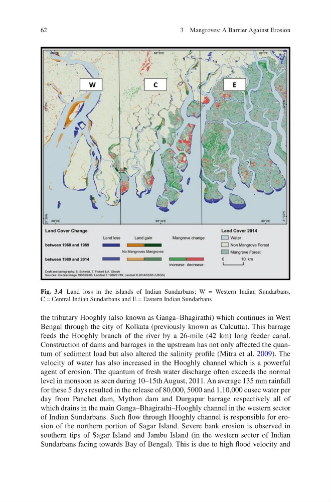
of Indian Sundarbans. Such flow through Hooghly channel is responsible for erosion of the northern portion of Sagar Island. Severe bank erosion is observed in
southern tips of Sagar Island and Jambu Island (in the western sector of Indian
Sundarbans facing towards Bay of Bengal). This is due to high flood velocity and
Fig. 3.4 Land loss in the islands of Indian Sundarbans; W = Western Indian Sundarbans,
C = Central Indian Sundarbans and E = Eastern Indian Sundarbans
3 Mangroves: A Barrier Against Erosion
the tributary Hooghly (also known as Ganga–Bhagirathi) which continues in West
Bengal through the city of Kolkata (previously known as Calcutta). This barrage
feeds the Hooghly branch of the river by a 26-mile (42 km) long feeder canal.
Construction of dams and barrages in the upstream has not only affected the quantum of sediment load but also altered the salinity profile (Mitra et al. 2009). The
velocity of water has also increased in the Hooghly channel which is a powerful
agent of erosion. The quantum of fresh water discharge often exceeds the normal
level in monsoon as seen during 10–15th August, 2011. An average 135 mm rainfall
for these 5 days resulted in the release of 80,000, 5000 and 1,10,000 cusec water per
day from Panchet dam, Mython dam and Durgapur barrage respectively all of
which drains in the main Ganga–Bhagirathi–Hooghly channel in the western sector
of Indian Sundarbans. Such flow through Hooghly channel is responsible for erosion of the northern portion of Sagar Island. Severe bank erosion is observed in
southern tips of Sagar Island and Jambu Island (in the western sector of Indian
Sundarbans facing towards Bay of Bengal). This is due to high flood velocity and
Fig. 3.4 Land loss in the islands of Indian Sundarbans; W = Western Indian Sundarbans,
C = Central Indian Sundarbans and E = Eastern Indian Sundarbans
3 Mangroves: A Barrier Against Erosion