

247
Where, H = Shannon-Weiner Species Diversity Index; P i = n i /N (n i = Number of
individuals of ith species and N = total number of individuals of all the species in
the quadrat). Ten quadrats were considered for the present study and the average
value of each species was considered for RA and H estimation.
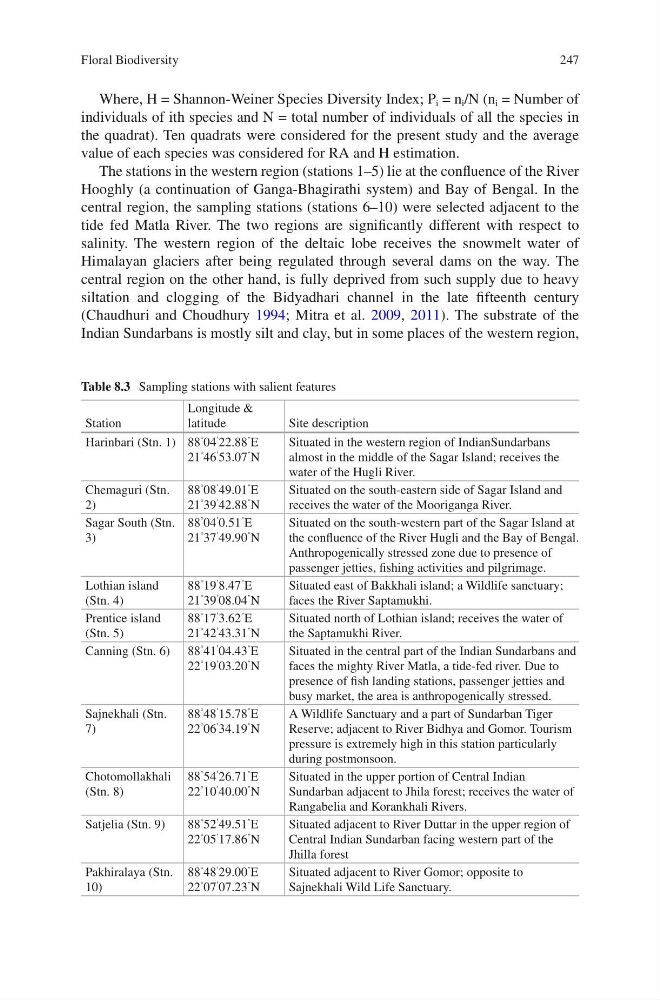
The stations in the western region (stations 1–5) lie at the confluence of the River
Hooghly (a continuation of Ganga-Bhagirathi system) and Bay of Bengal. In the
central region, the sampling stations (stations 6–10) were selected adjacent to the
tide fed Matla River. The two regions are significantly different with respect to
salinity. The western region of the deltaic lobe receives the snowmelt water of
Himalayan glaciers after being regulated through several dams on the way. The
central region on the other hand, is fully deprived from such supply due to heavy
siltation and clogging of the Bidyadhari channel in the late fifteenth century
(Chaudhuri and Choudhury 1994; Mitra et al. 2009, 2011). The substrate of the
Indian Sundarbans is mostly silt and clay, but in some places of the western region,
Table 8.3 Sampling stations with salient features
Station
Longitude &
latitude
Site description
Harinbari (Stn. 1) 88
° 04
′
22.88
″
E
21
° 46
′
53.07
″
N
Situated in the western region of IndianSundarbans
almost in the middle of the Sagar Island; receives the
water of the Hugli River.
Chemaguri (Stn.
2)
88
° 08
′
49.01
″
E
21
° 39
′
42.88
″
N
Situated on the south-eastern side of Sagar Island and
receives the water of the Mooriganga River.
Sagar South (Stn.
3)
88
° 04
′
0.51
″
E
21
° 37
′
49.90
″
N
Situated on the south-western part of the Sagar Island at
the confluence of the River Hugli and the Bay of Bengal.
Anthropogenically stressed zone due to presence of
passenger jetties, fishing activities and pilgrimage.
Lothian island
(Stn. 4)
88
° 19
′
8.47
″
E
21
° 39
′
08.04
″
N
Situated east of Bakkhali island; a Wildlife sanctuary;
faces the River Saptamukhi.
Prentice island
(Stn. 5)
88
° 17
′
3.62
″
E
21
° 42
′
43.31
″
N
Situated north of Lothian island; receives the water of
the Saptamukhi River.
Canning (Stn. 6) 88
° 41
′
04.43
″
E
22
° 19
′
03.20
″
N
Situated in the central part of the Indian Sundarbans and
faces the mighty River Matla, a tide-fed river. Due to
presence of fish landing stations, passenger jetties and
busy market, the area is anthropogenically stressed.
Sajnekhali (Stn.
7)
88
° 48
′
15.78
″
E
22
° 06
′
34.19
″
N
A Wildlife Sanctuary and a part of Sundarban Tiger
Reserve; adjacent to River Bidhya and Gomor. Tourism
pressure is extremely high in this station particularly
during postmonsoon.
Chotomollakhali
(Stn. 8)
88
° 54
′
26.71
″
E
22
° 10
′
40.00
″
N
Situated in the upper portion of Central Indian
Sundarban adjacent to Jhila forest; receives the water of
Rangabelia and Korankhali Rivers.
Satjelia (Stn. 9)
88
° 52
′
49.51
″
E
22
° 05
′
17.86
″
N
Situated adjacent to River Duttar in the upper region of
Central Indian Sundarban facing western part of the
Jhilla forest
Pakhiralaya (Stn.
10)
88
° 48
′
29.00
″
E
22
° 07
′
07.23
″
N
Situated adjacent to River Gomor; opposite to
Sajnekhali Wild Life Sanctuary.
Floral Biodiversity
Where, H = Shannon-Weiner Species Diversity Index; P i = n i /N (n i = Number of
individuals of ith species and N = total number of individuals of all the species in
the quadrat). Ten quadrats were considered for the present study and the average
value of each species was considered for RA and H estimation.
The stations in the western region (stations 1–5) lie at the confluence of the River
Hooghly (a continuation of Ganga-Bhagirathi system) and Bay of Bengal. In the
central region, the sampling stations (stations 6–10) were selected adjacent to the
tide fed Matla River. The two regions are significantly different with respect to
salinity. The western region of the deltaic lobe receives the snowmelt water of
Himalayan glaciers after being regulated through several dams on the way. The
central region on the other hand, is fully deprived from such supply due to heavy
siltation and clogging of the Bidyadhari channel in the late fifteenth century
(Chaudhuri and Choudhury 1994; Mitra et al. 2009, 2011). The substrate of the
Indian Sundarbans is mostly silt and clay, but in some places of the western region,
Table 8.3 Sampling stations with salient features
Station
Longitude &
latitude
Site description
Harinbari (Stn. 1) 88
° 04
′
22.88
″
E
21
° 46
′
53.07
″
N
Situated in the western region of IndianSundarbans
almost in the middle of the Sagar Island; receives the
water of the Hugli River.
Chemaguri (Stn.
2)
88
° 08
′
49.01
″
E
21
° 39
′
42.88
″
N
Situated on the south-eastern side of Sagar Island and
receives the water of the Mooriganga River.
Sagar South (Stn.
3)
88
° 04
′
0.51
″
E
21
° 37
′
49.90
″
N
Situated on the south-western part of the Sagar Island at
the confluence of the River Hugli and the Bay of Bengal.
Anthropogenically stressed zone due to presence of
passenger jetties, fishing activities and pilgrimage.
Lothian island
(Stn. 4)
88
° 19
′
8.47
″
E
21
° 39
′
08.04
″
N
Situated east of Bakkhali island; a Wildlife sanctuary;
faces the River Saptamukhi.
Prentice island
(Stn. 5)
88
° 17
′
3.62
″
E
21
° 42
′
43.31
″
N
Situated north of Lothian island; receives the water of
the Saptamukhi River.
Canning (Stn. 6) 88
° 41
′
04.43
″
E
22
° 19
′
03.20
″
N
Situated in the central part of the Indian Sundarbans and
faces the mighty River Matla, a tide-fed river. Due to
presence of fish landing stations, passenger jetties and
busy market, the area is anthropogenically stressed.
Sajnekhali (Stn.
7)
88
° 48
′
15.78
″
E
22
° 06
′
34.19
″
N
A Wildlife Sanctuary and a part of Sundarban Tiger
Reserve; adjacent to River Bidhya and Gomor. Tourism
pressure is extremely high in this station particularly
during postmonsoon.
Chotomollakhali
(Stn. 8)
88
° 54
′
26.71
″
E
22
° 10
′
40.00
″
N
Situated in the upper portion of Central Indian
Sundarban adjacent to Jhila forest; receives the water of
Rangabelia and Korankhali Rivers.
Satjelia (Stn. 9)
88
° 52
′
49.51
″
E
22
° 05
′
17.86
″
N
Situated adjacent to River Duttar in the upper region of
Central Indian Sundarban facing western part of the
Jhilla forest
Pakhiralaya (Stn.
10)
88
° 48
′
29.00
″
E
22
° 07
′
07.23
″
N
Situated adjacent to River Gomor; opposite to
Sajnekhali Wild Life Sanctuary.
Floral Biodiversity