

162
Scientists have found that sunny day floods have already increased by at least 300
percent in the US since the 1960s.
In context to India, The Independent (a news agency) reported in December 2006
that the first island claimed by rising sea levels caused by global warming in Indian
Sundarbans was Lohachara Island. However several scientists have contradicted the
correlation between erosion of Lohachara Island and global warming and forwarded
tectonic cause as one of the important reasons behind the loss of landmass of
Lohachara Island. The Indian Sundarbans at the apex of the Bay of Bengal (between
21°13′ to 22°40′ N latitude and 88°03′ to 89°07′ E longitude) is basically a mangrove
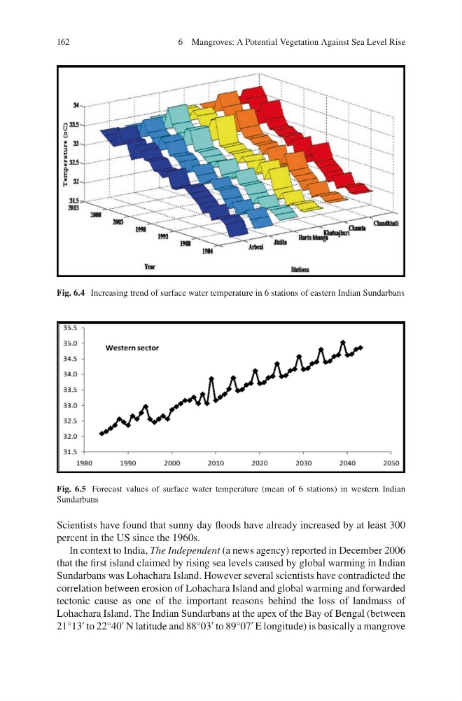
Fig. 6.4 Increasing trend of surface water temperature in 6 stations of eastern Indian Sundarbans
Fig. 6.5 Forecast values of surface water temperature (mean of 6 stations) in western Indian
Sundarbans
6 Mangroves: A Potential Vegetation Against Sea Level Rise
Scientists have found that sunny day floods have already increased by at least 300
percent in the US since the 1960s.
In context to India, The Independent (a news agency) reported in December 2006
that the first island claimed by rising sea levels caused by global warming in Indian
Sundarbans was Lohachara Island. However several scientists have contradicted the
correlation between erosion of Lohachara Island and global warming and forwarded
tectonic cause as one of the important reasons behind the loss of landmass of
Lohachara Island. The Indian Sundarbans at the apex of the Bay of Bengal (between
21°13′ to 22°40′ N latitude and 88°03′ to 89°07′ E longitude) is basically a mangrove
Fig. 6.4 Increasing trend of surface water temperature in 6 stations of eastern Indian Sundarbans
Fig. 6.5 Forecast values of surface water temperature (mean of 6 stations) in western Indian
Sundarbans
6 Mangroves: A Potential Vegetation Against Sea Level Rise