

28 Population Exposure to Emissions from Industry …
179
Industry emissions (SNAP 1, 4, 5, 9) are modeled as point sources based on
emission reports (11. BImSchVG) combined with data set on European stacks by
Pregger and Friedrich [13] to account for plume rise calculations within the CTM
system.
28.3 Chemical Transport Model Set-Up and Evaluation
of Reference Runs
The coupled meteorological and Chemistry Transport Model TAPM (The Air Pollution Model, Hurley [11] was used to calculate hourly three-dimensional concentration
fields and sector contributions of multiple pollutants, including PM 10 and PM 2.5 . The
hourly meteorological fields for the CTM study domain Hamburg (28 × 28 km
2 )
were obtained from the inner domain of a nested meteorological simulation with
TAPM with a 1-km horizontal resolution (28 × 28 km
2 extent). The meteorological component of TAPM is an incompressible, non-hydrostatic, primitive equation
model with a terrain following vertical sigma coordinate for 3-D simulations. The
outer domain is driven by three-hourly ECMWF ERA5 synoptic scale reanalyses
ensemble means on a longitude/latitude grid with 0.3 × 0.3°resolution. A vegetative
canopy, soil scheme, and an urban scheme with 7 urban land use classes [11] are
used at the surface, while radiative fluxes, both at the surface and at upper levels,
are also included. The terrain elevation data was adopted from the German Digital
Elevation Model [3] on 200-m horizontal resolution and the land use information was
adopted from the CORINE land cover database [5] on 100-m horizontal resolution
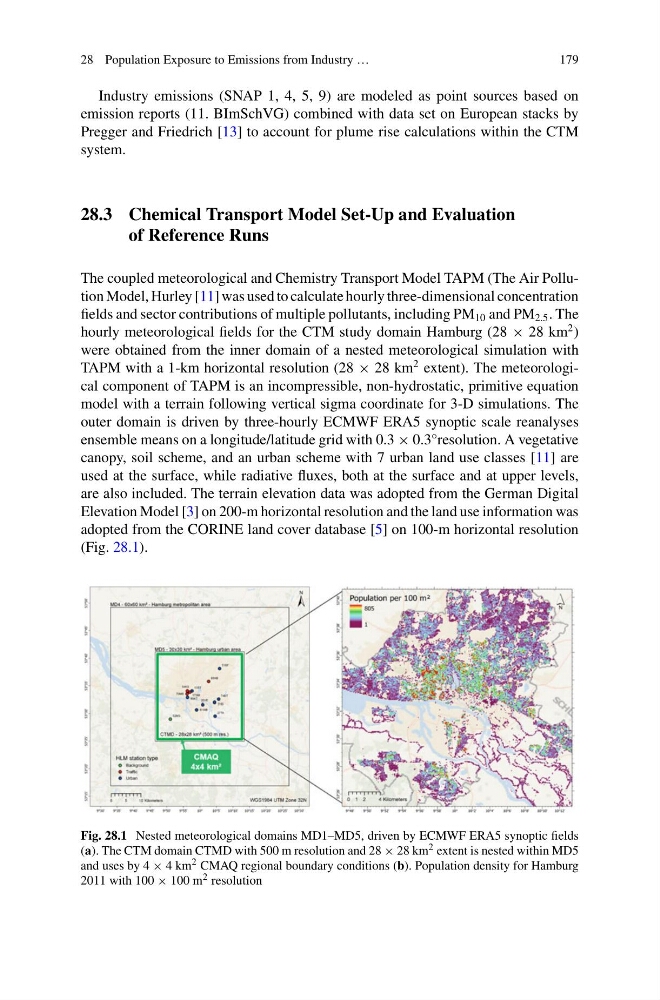
(Fig. 28.1).
Fig. 28.1 Nested meteorological domains MD1–MD5, driven by ECMWF ERA5 synoptic fields
(a). The CTM domain CTMD with 500 m resolution and 28 × 28 km 2 extent is nested within MD5
and uses by 4 × 4 km 2 CMAQ regional boundary conditions (b). Population density for Hamburg
2011 with 100 × 100 m 2 resolution
179
Industry emissions (SNAP 1, 4, 5, 9) are modeled as point sources based on
emission reports (11. BImSchVG) combined with data set on European stacks by
Pregger and Friedrich [13] to account for plume rise calculations within the CTM
system.
28.3 Chemical Transport Model Set-Up and Evaluation
of Reference Runs
The coupled meteorological and Chemistry Transport Model TAPM (The Air Pollution Model, Hurley [11] was used to calculate hourly three-dimensional concentration
fields and sector contributions of multiple pollutants, including PM 10 and PM 2.5 . The
hourly meteorological fields for the CTM study domain Hamburg (28 × 28 km
2 )
were obtained from the inner domain of a nested meteorological simulation with
TAPM with a 1-km horizontal resolution (28 × 28 km
2 extent). The meteorological component of TAPM is an incompressible, non-hydrostatic, primitive equation
model with a terrain following vertical sigma coordinate for 3-D simulations. The
outer domain is driven by three-hourly ECMWF ERA5 synoptic scale reanalyses
ensemble means on a longitude/latitude grid with 0.3 × 0.3°resolution. A vegetative
canopy, soil scheme, and an urban scheme with 7 urban land use classes [11] are
used at the surface, while radiative fluxes, both at the surface and at upper levels,
are also included. The terrain elevation data was adopted from the German Digital
Elevation Model [3] on 200-m horizontal resolution and the land use information was
adopted from the CORINE land cover database [5] on 100-m horizontal resolution
(Fig. 28.1).
Fig. 28.1 Nested meteorological domains MD1–MD5, driven by ECMWF ERA5 synoptic fields
(a). The CTM domain CTMD with 500 m resolution and 28 × 28 km 2 extent is nested within MD5
and uses by 4 × 4 km 2 CMAQ regional boundary conditions (b). Population density for Hamburg
2011 with 100 × 100 m 2 resolution