

160
N. Moussiopoulos et al.
25.2 Methodology and Case Setup
In the first part of the Piraeus study, emissions from marine traffic were calculated for
two distinct areas, corresponding to the main port area of Piraeus and the designated
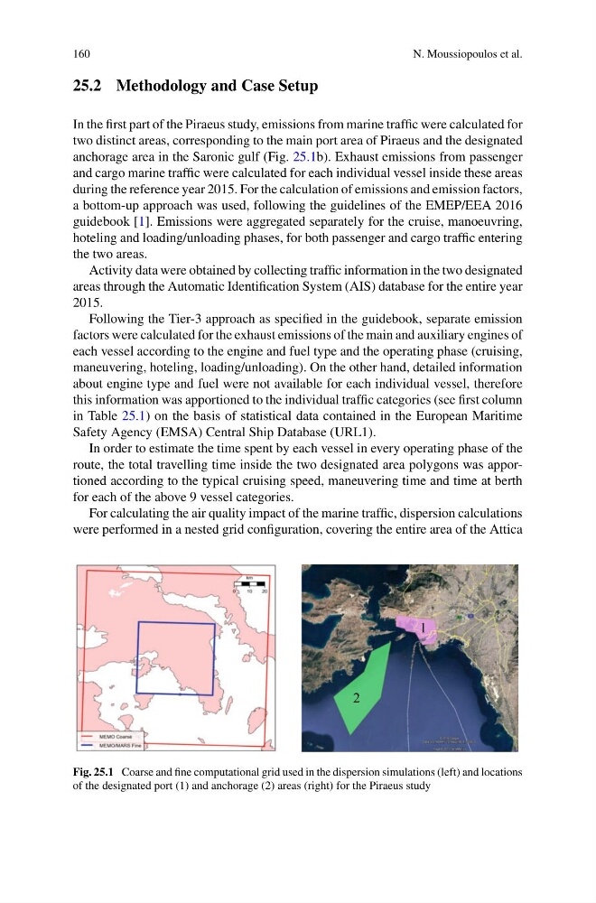
anchorage area in the Saronic gulf (Fig. 25.1b). Exhaust emissions from passenger
and cargo marine traffic were calculated for each individual vessel inside these areas
during the reference year 2015. For the calculation of emissions and emission factors,
a bottom-up approach was used, following the guidelines of the EMEP/EEA 2016
guidebook [1]. Emissions were aggregated separately for the cruise, manoeuvring,
hoteling and loading/unloading phases, for both passenger and cargo traffic entering
the two areas.
Activity data were obtained by collecting traffic information in the two designated
areas through the Automatic Identification System (AIS) database for the entire year
2015.
Following the Tier-3 approach as specified in the guidebook, separate emission
factors were calculated for the exhaust emissions of the main and auxiliary engines of
each vessel according to the engine and fuel type and the operating phase (cruising,
maneuvering, hoteling, loading/unloading). On the other hand, detailed information
about engine type and fuel were not available for each individual vessel, therefore
this information was apportioned to the individual traffic categories (see first column
in Table 25.1) on the basis of statistical data contained in the European Maritime
Safety Agency (EMSA) Central Ship Database (URL1).
In order to estimate the time spent by each vessel in every operating phase of the
route, the total travelling time inside the two designated area polygons was apportioned according to the typical cruising speed, maneuvering time and time at berth
for each of the above 9 vessel categories.
For calculating the air quality impact of the marine traffic, dispersion calculations
were performed in a nested grid configuration, covering the entire area of the Attica
1
2
Fig. 25.1 Coarse and fine computational grid used in the dispersion simulations (left) and locations
of the designated port (1) and anchorage (2) areas (right) for the Piraeus study
N. Moussiopoulos et al.
25.2 Methodology and Case Setup
In the first part of the Piraeus study, emissions from marine traffic were calculated for
two distinct areas, corresponding to the main port area of Piraeus and the designated
anchorage area in the Saronic gulf (Fig. 25.1b). Exhaust emissions from passenger
and cargo marine traffic were calculated for each individual vessel inside these areas
during the reference year 2015. For the calculation of emissions and emission factors,
a bottom-up approach was used, following the guidelines of the EMEP/EEA 2016
guidebook [1]. Emissions were aggregated separately for the cruise, manoeuvring,
hoteling and loading/unloading phases, for both passenger and cargo traffic entering
the two areas.
Activity data were obtained by collecting traffic information in the two designated
areas through the Automatic Identification System (AIS) database for the entire year
2015.
Following the Tier-3 approach as specified in the guidebook, separate emission
factors were calculated for the exhaust emissions of the main and auxiliary engines of
each vessel according to the engine and fuel type and the operating phase (cruising,
maneuvering, hoteling, loading/unloading). On the other hand, detailed information
about engine type and fuel were not available for each individual vessel, therefore
this information was apportioned to the individual traffic categories (see first column
in Table 25.1) on the basis of statistical data contained in the European Maritime
Safety Agency (EMSA) Central Ship Database (URL1).
In order to estimate the time spent by each vessel in every operating phase of the
route, the total travelling time inside the two designated area polygons was apportioned according to the typical cruising speed, maneuvering time and time at berth
for each of the above 9 vessel categories.
For calculating the air quality impact of the marine traffic, dispersion calculations
were performed in a nested grid configuration, covering the entire area of the Attica
1
2
Fig. 25.1 Coarse and fine computational grid used in the dispersion simulations (left) and locations
of the designated port (1) and anchorage (2) areas (right) for the Piraeus study