

80
A. Bisignano et al.
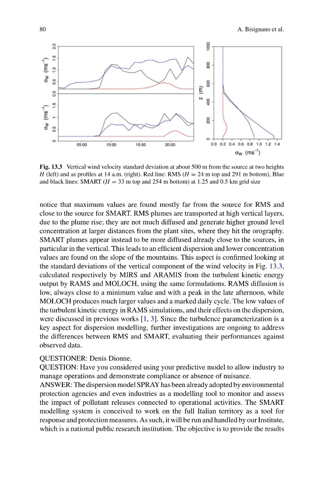
Fig. 13.3 Vertical wind velocity standard deviation at about 500 m from the source at two heights
H (left) and as profiles at 14 a.m. (right). Red line: RMS (H = 24 m top and 291 m bottom), Blue
and black lines: SMART (H = 33 m top and 254 m bottom) at 1.25 and 0.5 km grid size
notice that maximum values are found mostly far from the source for RMS and
close to the source for SMART. RMS plumes are transported at high vertical layers,
due to the plume rise; they are not much diffused and generate higher ground level
concentration at larger distances from the plant sites, where they hit the orography.
SMART plumes appear instead to be more diffused already close to the sources, in
particular in the vertical. This leads to an efficient dispersion and lower concentration
values are found on the slope of the mountains. This aspect is confirmed looking at
the standard deviations of the vertical component of the wind velocity in Fig. 13.3,
calculated respectively by MIRS and ARAMIS from the turbulent kinetic energy
output by RAMS and MOLOCH, using the same formulations. RAMS diffusion is
low, always close to a minimum value and with a peak in the late afternoon, while
MOLOCH produces much larger values and a marked daily cycle. The low values of
the turbulent kinetic energy in RAMS simulations, and their effects on the dispersion,
were discussed in previous works [1, 3]. Since the turbulence parameterization is a
key aspect for dispersion modelling, further investigations are ongoing to address
the differences between RMS and SMART, evaluating their performances against
observed data.
QUESTIONER: Denis Dionne.
QUESTION: Have you considered using your predictive model to allow industry to
manage operations and demonstrate compliance or absence of nuisance.
ANSWER: The dispersion model SPRAY has been already adopted by environmental
protection agencies and even industries as a modelling tool to monitor and assess
the impact of pollutant releases connected to operational activities. The SMART
modelling system is conceived to work on the full Italian territory as a tool for
response and protection measures. As such, it will be run and handled by our Institute,
which is a national public research institution. The objective is to provide the results
A. Bisignano et al.
Fig. 13.3 Vertical wind velocity standard deviation at about 500 m from the source at two heights
H (left) and as profiles at 14 a.m. (right). Red line: RMS (H = 24 m top and 291 m bottom), Blue
and black lines: SMART (H = 33 m top and 254 m bottom) at 1.25 and 0.5 km grid size
notice that maximum values are found mostly far from the source for RMS and
close to the source for SMART. RMS plumes are transported at high vertical layers,
due to the plume rise; they are not much diffused and generate higher ground level
concentration at larger distances from the plant sites, where they hit the orography.
SMART plumes appear instead to be more diffused already close to the sources, in
particular in the vertical. This leads to an efficient dispersion and lower concentration
values are found on the slope of the mountains. This aspect is confirmed looking at
the standard deviations of the vertical component of the wind velocity in Fig. 13.3,
calculated respectively by MIRS and ARAMIS from the turbulent kinetic energy
output by RAMS and MOLOCH, using the same formulations. RAMS diffusion is
low, always close to a minimum value and with a peak in the late afternoon, while
MOLOCH produces much larger values and a marked daily cycle. The low values of
the turbulent kinetic energy in RAMS simulations, and their effects on the dispersion,
were discussed in previous works [1, 3]. Since the turbulence parameterization is a
key aspect for dispersion modelling, further investigations are ongoing to address
the differences between RMS and SMART, evaluating their performances against
observed data.
QUESTIONER: Denis Dionne.
QUESTION: Have you considered using your predictive model to allow industry to
manage operations and demonstrate compliance or absence of nuisance.
ANSWER: The dispersion model SPRAY has been already adopted by environmental
protection agencies and even industries as a modelling tool to monitor and assess
the impact of pollutant releases connected to operational activities. The SMART
modelling system is conceived to work on the full Italian territory as a tool for
response and protection measures. As such, it will be run and handled by our Institute,
which is a national public research institution. The objective is to provide the results