

196
A. Solyman and T. Abdel Monem
Table 2 The total number of districts affected by the different scenarios
Governorate
Number of impacted districts
Scenario 1
Scenario 2
Scenario 3
Scenario 4
Alexanderia
9
9
10
13
Behira
11
12
13
14
Dakahlia
6
7
7
8
Damietta
6
6
6
6
Ismailia
1
1
2
2
Kafr Alshikh
6
7
9
9
Port Said
3
3
3
4
Sharkia
1
1
2
2
Total
43
46
52
58
Table 3 The highest impacted districts by each scenario
Scenario
Number of affected
districts
The highest impacted
district
Governorate
% Area affected
Scenario 1 (25 cm)
SLR
43
Kesm-Port_Fouad
Port Said
14.12
Scenario 2 (50 cm)
SLR
46
Mitubas
Kafr El-Shikh 22.5057
Scenario 3 (75 cm)
SLR
52
Mitubas
Kafr El-Shikh 30.0684
Scenario 4 (100 cm)
SLR
58
Fouh
Kafr El-Shikh 39.5121
than others. Geographic Information System (GIS) is capable of creating, analyzing,
and displaying sea level rise scenarios enabling local officials and decision makers
to address the negative effects of elevated sea levels by allowing them to identify
affected communities that are at risk, assess the situation, and develop adaptation
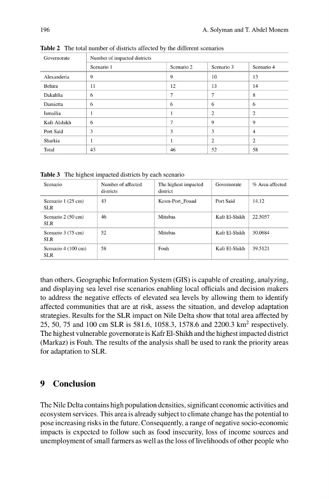
strategies. Results for the SLR impact on Nile Delta show that total area affected by
25, 50, 75 and 100 cm SLR is 581.6, 1058.3, 1578.6 and 2200.3 km
2 respectively.
The highest vulnerable governorate is Kafr El-Shikh and the highest impacted district
(Markaz) is Fouh. The results of the analysis shall be used to rank the priority areas
for adaptation to SLR.
9 Conclusion
The Nile Delta contains high population densities, significant economic activities and
ecosystem services. This area is already subject to climate change has the potential to
pose increasing risks in the future. Consequently, a range of negative socio-economic
impacts is expected to follow such as food insecurity, loss of income sources and
unemployment of small farmers as well as the loss of livelihoods of other people who
A. Solyman and T. Abdel Monem
Table 2 The total number of districts affected by the different scenarios
Governorate
Number of impacted districts
Scenario 1
Scenario 2
Scenario 3
Scenario 4
Alexanderia
9
9
10
13
Behira
11
12
13
14
Dakahlia
6
7
7
8
Damietta
6
6
6
6
Ismailia
1
1
2
2
Kafr Alshikh
6
7
9
9
Port Said
3
3
3
4
Sharkia
1
1
2
2
Total
43
46
52
58
Table 3 The highest impacted districts by each scenario
Scenario
Number of affected
districts
The highest impacted
district
Governorate
% Area affected
Scenario 1 (25 cm)
SLR
43
Kesm-Port_Fouad
Port Said
14.12
Scenario 2 (50 cm)
SLR
46
Mitubas
Kafr El-Shikh 22.5057
Scenario 3 (75 cm)
SLR
52
Mitubas
Kafr El-Shikh 30.0684
Scenario 4 (100 cm)
SLR
58
Fouh
Kafr El-Shikh 39.5121
than others. Geographic Information System (GIS) is capable of creating, analyzing,
and displaying sea level rise scenarios enabling local officials and decision makers
to address the negative effects of elevated sea levels by allowing them to identify
affected communities that are at risk, assess the situation, and develop adaptation
strategies. Results for the SLR impact on Nile Delta show that total area affected by
25, 50, 75 and 100 cm SLR is 581.6, 1058.3, 1578.6 and 2200.3 km
2 respectively.
The highest vulnerable governorate is Kafr El-Shikh and the highest impacted district
(Markaz) is Fouh. The results of the analysis shall be used to rank the priority areas
for adaptation to SLR.
9 Conclusion
The Nile Delta contains high population densities, significant economic activities and
ecosystem services. This area is already subject to climate change has the potential to
pose increasing risks in the future. Consequently, a range of negative socio-economic
impacts is expected to follow such as food insecurity, loss of income sources and
unemployment of small farmers as well as the loss of livelihoods of other people who