

Mapping Egypt Vulnerability to Sea Level Rise Scenarios
195
7 Results
According to the SLRS, the impact of SLR on the coastal areas by each scenario is
shown in Table 1.
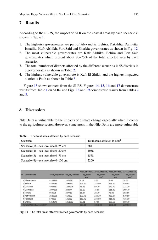
1. The high-risk governorates are part of Alexandria, Behira, Dakahlia, Damietta,
Ismailia, Kafr Alshikh, Port Said and Sharkia governorates as shown in Fig. 12.
2. The most vulnerable governorates are Kafr Alshikh, Behira and Port Said
governorates which present about 70–75% of the total affected area by each
scenario.
3. The total number of districts affected by the different scenarios is 58 districts in
8 governorates as shown in Table 2.
4. The highest vulnerable governorate is Kafr El-Shikh, and the highest impacted
district is Fouh as shown in Table 3.
Figure 13 shows extracts from the SLRS. Figures 14, 15, 16 and 17 demonstrate
results from Table 1 on SLRS and Figs. 18 and 19 demonstrate results from Tables 2
and 3.
8 Discussion
Nile Delta is vulnerable to the impacts of climate change especially when it comes
to the agriculture sector. However, some areas in the Nile Delta are more vulnerable
Table 1 The total areas affected by each scenario
Scenario
Total areas affected in Km 2
Scenario (1)—sea level rise 0–25 cm
581
Scenario (2)—sea level rise 0–50 cm
1058
Scenario (3)—sea level rise 0–75 cm
1578
Scenario (4)—sea level rise 0–100 cm
2200
Fig. 12 The total areas affected in each governorate by each scenario
195
7 Results
According to the SLRS, the impact of SLR on the coastal areas by each scenario is
shown in Table 1.
1. The high-risk governorates are part of Alexandria, Behira, Dakahlia, Damietta,
Ismailia, Kafr Alshikh, Port Said and Sharkia governorates as shown in Fig. 12.
2. The most vulnerable governorates are Kafr Alshikh, Behira and Port Said
governorates which present about 70–75% of the total affected area by each
scenario.
3. The total number of districts affected by the different scenarios is 58 districts in
8 governorates as shown in Table 2.
4. The highest vulnerable governorate is Kafr El-Shikh, and the highest impacted
district is Fouh as shown in Table 3.
Figure 13 shows extracts from the SLRS. Figures 14, 15, 16 and 17 demonstrate
results from Table 1 on SLRS and Figs. 18 and 19 demonstrate results from Tables 2
and 3.
8 Discussion
Nile Delta is vulnerable to the impacts of climate change especially when it comes
to the agriculture sector. However, some areas in the Nile Delta are more vulnerable
Table 1 The total areas affected by each scenario
Scenario
Total areas affected in Km 2
Scenario (1)—sea level rise 0–25 cm
581
Scenario (2)—sea level rise 0–50 cm
1058
Scenario (3)—sea level rise 0–75 cm
1578
Scenario (4)—sea level rise 0–100 cm
2200
Fig. 12 The total areas affected in each governorate by each scenario