

Mapping Egypt Vulnerability to Sea Level Rise Scenarios
191
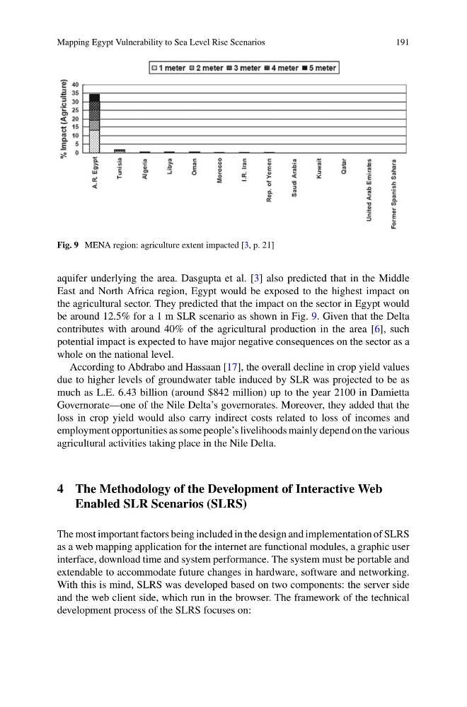
Fig. 9 MENA region: agriculture extent impacted [3, p. 21]
aquifer underlying the area. Dasgupta et al. [3] also predicted that in the Middle
East and North Africa region, Egypt would be exposed to the highest impact on
the agricultural sector. They predicted that the impact on the sector in Egypt would
be around 12.5% for a 1 m SLR scenario as shown in Fig. 9. Given that the Delta
contributes with around 40% of the agricultural production in the area [6], such
potential impact is expected to have major negative consequences on the sector as a
whole on the national level.
According to Abdrabo and Hassaan [17], the overall decline in crop yield values
due to higher levels of groundwater table induced by SLR was projected to be as
much as L.E. 6.43 billion (around $842 million) up to the year 2100 in Damietta
Governorate—one of the Nile Delta’s governorates. Moreover, they added that the
loss in crop yield would also carry indirect costs related to loss of incomes and
employment opportunities as some people’s livelihoods mainly depend on the various
agricultural activities taking place in the Nile Delta.
4 The Methodology of the Development of Interactive Web
Enabled SLR Scenarios (SLRS)
The most important factors being included in the design and implementation of SLRS
as a web mapping application for the internet are functional modules, a graphic user
interface, download time and system performance. The system must be portable and
extendable to accommodate future changes in hardware, software and networking.
With this is mind, SLRS was developed based on two components: the server side
and the web client side, which run in the browser. The framework of the technical
development process of the SLRS focuses on:
191
Fig. 9 MENA region: agriculture extent impacted [3, p. 21]
aquifer underlying the area. Dasgupta et al. [3] also predicted that in the Middle
East and North Africa region, Egypt would be exposed to the highest impact on
the agricultural sector. They predicted that the impact on the sector in Egypt would
be around 12.5% for a 1 m SLR scenario as shown in Fig. 9. Given that the Delta
contributes with around 40% of the agricultural production in the area [6], such
potential impact is expected to have major negative consequences on the sector as a
whole on the national level.
According to Abdrabo and Hassaan [17], the overall decline in crop yield values
due to higher levels of groundwater table induced by SLR was projected to be as
much as L.E. 6.43 billion (around $842 million) up to the year 2100 in Damietta
Governorate—one of the Nile Delta’s governorates. Moreover, they added that the
loss in crop yield would also carry indirect costs related to loss of incomes and
employment opportunities as some people’s livelihoods mainly depend on the various
agricultural activities taking place in the Nile Delta.
4 The Methodology of the Development of Interactive Web
Enabled SLR Scenarios (SLRS)
The most important factors being included in the design and implementation of SLRS
as a web mapping application for the internet are functional modules, a graphic user
interface, download time and system performance. The system must be portable and
extendable to accommodate future changes in hardware, software and networking.
With this is mind, SLRS was developed based on two components: the server side
and the web client side, which run in the browser. The framework of the technical
development process of the SLRS focuses on: