

Mapping Egypt Vulnerability to Sea Level Rise Scenarios
185
vulnerable to SLR on the Nile Delta coast. Four scenarios are implemented to assess
the impact of SLR, for 25, 50, 75 and 100 cm.
2 Study Area: Nile Delta
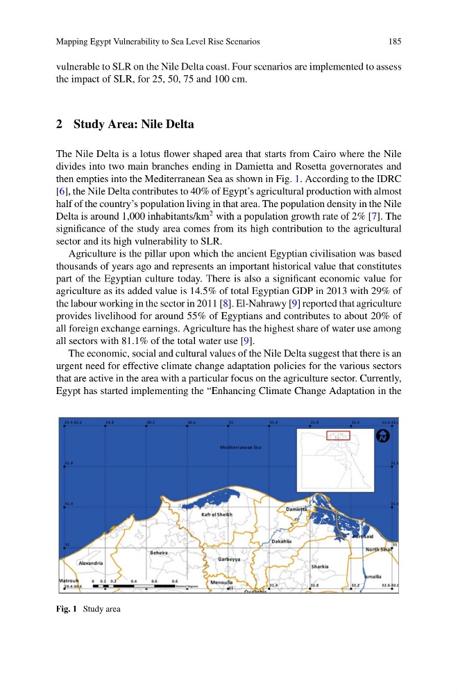
The Nile Delta is a lotus flower shaped area that starts from Cairo where the Nile
divides into two main branches ending in Damietta and Rosetta governorates and
then empties into the Mediterranean Sea as shown in Fig. 1. According to the IDRC
[6], the Nile Delta contributes to 40% of Egypt’s agricultural production with almost
half of the country’s population living in that area. The population density in the Nile
Delta is around 1,000 inhabitants/km
2 with a population growth rate of 2% [7]. The
significance of the study area comes from its high contribution to the agricultural
sector and its high vulnerability to SLR.
Agriculture is the pillar upon which the ancient Egyptian civilisation was based
thousands of years ago and represents an important historical value that constitutes
part of the Egyptian culture today. There is also a significant economic value for
agriculture as its added value is 14.5% of total Egyptian GDP in 2013 with 29% of
the labour working in the sector in 2011 [8]. El-Nahrawy [9] reported that agriculture
provides livelihood for around 55% of Egyptians and contributes to about 20% of
all foreign exchange earnings. Agriculture has the highest share of water use among
all sectors with 81.1% of the total water use [9].
The economic, social and cultural values of the Nile Delta suggest that there is an
urgent need for effective climate change adaptation policies for the various sectors
that are active in the area with a particular focus on the agriculture sector. Currently,
Egypt has started implementing the “Enhancing Climate Change Adaptation in the
Fig. 1 Study area
185
vulnerable to SLR on the Nile Delta coast. Four scenarios are implemented to assess
the impact of SLR, for 25, 50, 75 and 100 cm.
2 Study Area: Nile Delta
The Nile Delta is a lotus flower shaped area that starts from Cairo where the Nile
divides into two main branches ending in Damietta and Rosetta governorates and
then empties into the Mediterranean Sea as shown in Fig. 1. According to the IDRC
[6], the Nile Delta contributes to 40% of Egypt’s agricultural production with almost
half of the country’s population living in that area. The population density in the Nile
Delta is around 1,000 inhabitants/km
2 with a population growth rate of 2% [7]. The
significance of the study area comes from its high contribution to the agricultural
sector and its high vulnerability to SLR.
Agriculture is the pillar upon which the ancient Egyptian civilisation was based
thousands of years ago and represents an important historical value that constitutes
part of the Egyptian culture today. There is also a significant economic value for
agriculture as its added value is 14.5% of total Egyptian GDP in 2013 with 29% of
the labour working in the sector in 2011 [8]. El-Nahrawy [9] reported that agriculture
provides livelihood for around 55% of Egyptians and contributes to about 20% of
all foreign exchange earnings. Agriculture has the highest share of water use among
all sectors with 81.1% of the total water use [9].
The economic, social and cultural values of the Nile Delta suggest that there is an
urgent need for effective climate change adaptation policies for the various sectors
that are active in the area with a particular focus on the agriculture sector. Currently,
Egypt has started implementing the “Enhancing Climate Change Adaptation in the
Fig. 1 Study area