

Transitional Peri-urban Landscape …
441
66 km
2 . Availability and easy accessibility of land in the city surrounding is a major
enabling factor for city expansion creating a broader transitional peri-urban area.
Considering the prospect of urban growth and existence of ecologically sensitive
features, the Rani-Deepor Beel-Garbhanga landscape has been selected as the study
area. There has been immense filling up of agricultural land and several water bodies
to give place to concrete development. The Deepor Beel of Assam (Kamrup District)
is a Wetland of International Importance declared in Ramsar Convention. Due to
variation in vegetation structures, the forest has been divided into two forest ranges
-the Garbhanga range (18,861 ha) and the Rani range (4370 ha). The forest reserve
is also continuous with the Jarasal-Kwasing Reserve, Nakhalliyang Wildlife Sanctuary and Jirang State Forest of the neighbouring state of Meghalaya. The climate of
the area is characterised by high humidity (80–90% maximum recorded) and moderate temperature. Humid tropical climate of the region has a prolonged monsoon
of 5 months (May to September) and a relatively cool and dry winter. The average
minimum and maximum temperature of the area are 10.6 °C and 32 °C respectively.
The landscape receives heavy rainfall of 300–450 cm.
The city of Guwahati has a better urban poverty ratio (9.09% urban poor) as
compared to urban India’s percentage of 13.7, although the Assam has a higher
urban poverty with 20%. But the selected landscape has a very low per capita annual
income (Rs. 11,585). 18.13% of the total population is scheduled tribe; that part
of the population belongs towards the rural gradient of the landscape and the tribal
communities are in the villages of the hilly region, which belong to Rani Gram
Panchayat and Azara Gram Panchayat, which are under the low, or no urbanization
region of the landscape. Scheduled caste population of the area is accounted for
10.37% and they live in the plain area. In the selected study landscape, the population
growth from 1991 to 2001 is 29.6% and from 2001 to 2011 is 17.8% in comparison
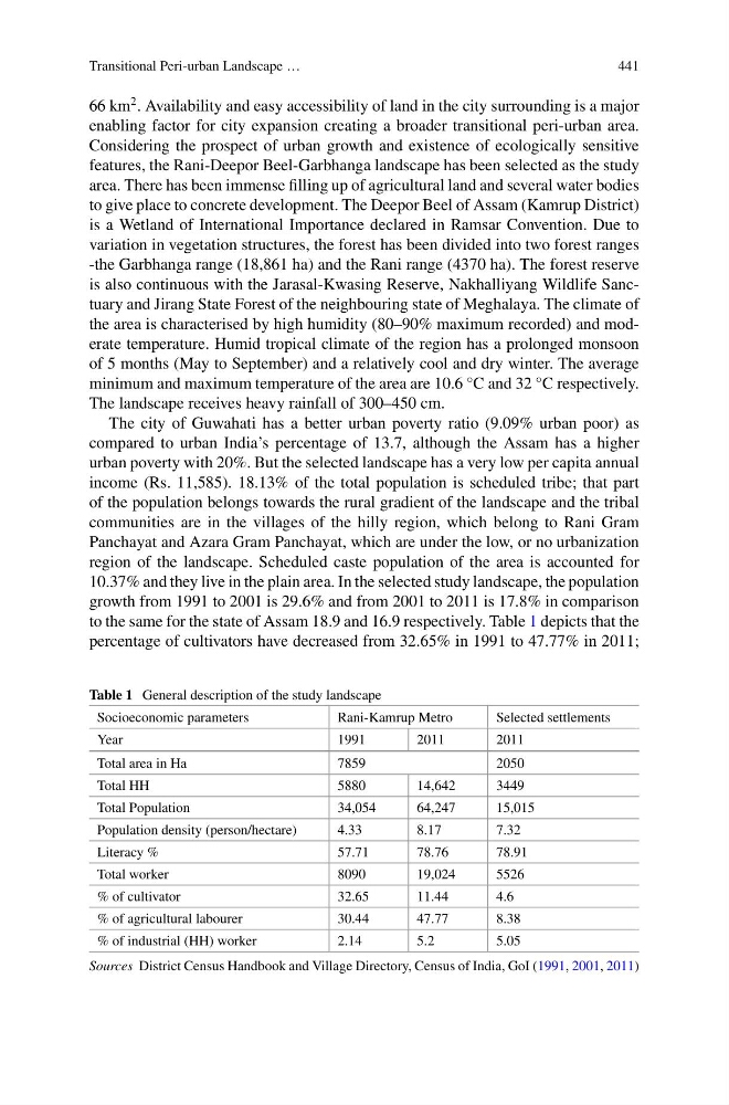
to the same for the state of Assam 18.9 and 16.9 respectively. Table 1 depicts that the
percentage of cultivators have decreased from 32.65% in 1991 to 47.77% in 2011;
Table 1 General description of the study landscape
Socioeconomic parameters
Rani-Kamrup Metro
Selected settlements
Year
1991
2011
2011
Total area in Ha
7859
2050
Total HH
5880
14,642
3449
Total Population
34,054
64,247
15,015
Population density (person/hectare)
4.33
8.17
7.32
Literacy %
57.71
78.76
78.91
Total worker
8090
19,024
5526
% of cultivator
32.65
11.44
4.6
% of agricultural labourer
30.44
47.77
8.38
% of industrial (HH) worker
2.14
5.2
5.05
Sources District Census Handbook and Village Directory, Census of India, GoI (1991, 2001, 2011)
441
66 km
2 . Availability and easy accessibility of land in the city surrounding is a major
enabling factor for city expansion creating a broader transitional peri-urban area.
Considering the prospect of urban growth and existence of ecologically sensitive
features, the Rani-Deepor Beel-Garbhanga landscape has been selected as the study
area. There has been immense filling up of agricultural land and several water bodies
to give place to concrete development. The Deepor Beel of Assam (Kamrup District)
is a Wetland of International Importance declared in Ramsar Convention. Due to
variation in vegetation structures, the forest has been divided into two forest ranges
-the Garbhanga range (18,861 ha) and the Rani range (4370 ha). The forest reserve
is also continuous with the Jarasal-Kwasing Reserve, Nakhalliyang Wildlife Sanctuary and Jirang State Forest of the neighbouring state of Meghalaya. The climate of
the area is characterised by high humidity (80–90% maximum recorded) and moderate temperature. Humid tropical climate of the region has a prolonged monsoon
of 5 months (May to September) and a relatively cool and dry winter. The average
minimum and maximum temperature of the area are 10.6 °C and 32 °C respectively.
The landscape receives heavy rainfall of 300–450 cm.
The city of Guwahati has a better urban poverty ratio (9.09% urban poor) as
compared to urban India’s percentage of 13.7, although the Assam has a higher
urban poverty with 20%. But the selected landscape has a very low per capita annual
income (Rs. 11,585). 18.13% of the total population is scheduled tribe; that part
of the population belongs towards the rural gradient of the landscape and the tribal
communities are in the villages of the hilly region, which belong to Rani Gram
Panchayat and Azara Gram Panchayat, which are under the low, or no urbanization
region of the landscape. Scheduled caste population of the area is accounted for
10.37% and they live in the plain area. In the selected study landscape, the population
growth from 1991 to 2001 is 29.6% and from 2001 to 2011 is 17.8% in comparison
to the same for the state of Assam 18.9 and 16.9 respectively. Table 1 depicts that the
percentage of cultivators have decreased from 32.65% in 1991 to 47.77% in 2011;
Table 1 General description of the study landscape
Socioeconomic parameters
Rani-Kamrup Metro
Selected settlements
Year
1991
2011
2011
Total area in Ha
7859
2050
Total HH
5880
14,642
3449
Total Population
34,054
64,247
15,015
Population density (person/hectare)
4.33
8.17
7.32
Literacy %
57.71
78.76
78.91
Total worker
8090
19,024
5526
% of cultivator
32.65
11.44
4.6
% of agricultural labourer
30.44
47.77
8.38
% of industrial (HH) worker
2.14
5.2
5.05
Sources District Census Handbook and Village Directory, Census of India, GoI (1991, 2001, 2011)