

230
4.2.2 Annual Precipitation
Precipitation dynamics of NWH are very complex because of orographic influences. Wintertime precipitation is influenced by Western disturbances (WDs)
(Cannon et al. 2016), whereas precipitation inputs in summer season are mainly
because of Indian summer monsoon (Hewitt 2014). When easterly propagating
WDs enter Indian Himalayas, their first encounter with LH makes WDs pour maximum moisture over LH followed by GH and KH. Hence, minimum precipitation is
received by KH in spite of having highest elevation (Negi et al. 2018). This pattern
is also well captured by both ERA-I and CRU-TS (Fig. 7). Since NWH has many
mountain ranges with different aspects, many pockets with comparatively higher
(windward side) or lower precipitation (leeward side) are inevitable. Though none
of the gridded datasets have the potential to capture minute details, yet because of
higher resolution, ERA-I could distinctly capture precipitation distribution than
CRU-TS. However, ERA-I overestimates the precipitation amount which could be
due to the fact that validation was done using point observations which could have
had influences of topography/microclimate whereas the dataset derived values represented whole KH range. As a matter of fact, this overestimation by ERA-I is
accepted by many researchers worldwide (Palazzi et al. 2013; Immerzeel et al.
2015) for they believe that only this high precipitation can sustain large glacier
masses in high Himalayas.
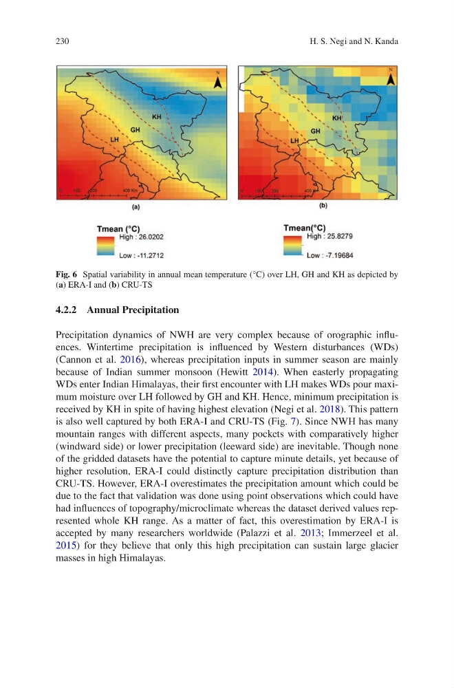
Fig. 6 Spatial variability in annual mean temperature (°C) over LH, GH and KH as depicted by
(a) ERA-I and (b) CRU-TS
H. S. Negi and N. Kanda
4.2.2 Annual Precipitation
Precipitation dynamics of NWH are very complex because of orographic influences. Wintertime precipitation is influenced by Western disturbances (WDs)
(Cannon et al. 2016), whereas precipitation inputs in summer season are mainly
because of Indian summer monsoon (Hewitt 2014). When easterly propagating
WDs enter Indian Himalayas, their first encounter with LH makes WDs pour maximum moisture over LH followed by GH and KH. Hence, minimum precipitation is
received by KH in spite of having highest elevation (Negi et al. 2018). This pattern
is also well captured by both ERA-I and CRU-TS (Fig. 7). Since NWH has many
mountain ranges with different aspects, many pockets with comparatively higher
(windward side) or lower precipitation (leeward side) are inevitable. Though none
of the gridded datasets have the potential to capture minute details, yet because of
higher resolution, ERA-I could distinctly capture precipitation distribution than
CRU-TS. However, ERA-I overestimates the precipitation amount which could be
due to the fact that validation was done using point observations which could have
had influences of topography/microclimate whereas the dataset derived values represented whole KH range. As a matter of fact, this overestimation by ERA-I is
accepted by many researchers worldwide (Palazzi et al. 2013; Immerzeel et al.
2015) for they believe that only this high precipitation can sustain large glacier
masses in high Himalayas.
Fig. 6 Spatial variability in annual mean temperature (°C) over LH, GH and KH as depicted by
(a) ERA-I and (b) CRU-TS
H. S. Negi and N. Kanda