

105
3 Results and Discussion
3.1 The WRF Model Simulations
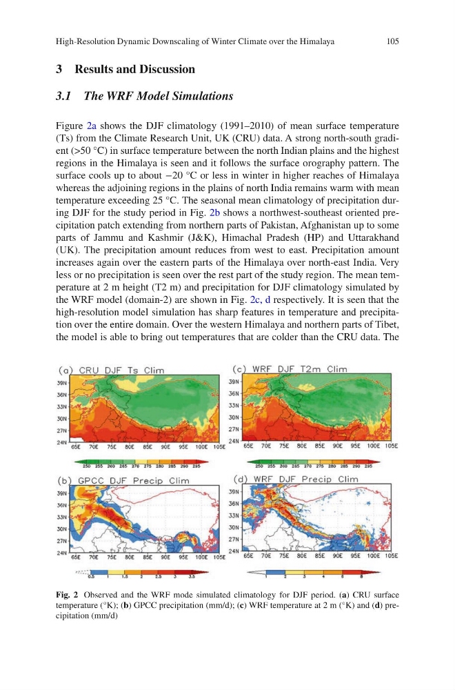
Figure 2a shows the DJF climatology (1991–2010) of mean surface temperature
(Ts) from the Climate Research Unit, UK (CRU) data. A strong north-south gradient (>50 °C) in surface temperature between the north Indian plains and the highest
regions in the Himalaya is seen and it follows the surface orography pattern. The
surface cools up to about −20 °C or less in winter in higher reaches of Himalaya
whereas the adjoining regions in the plains of north India remains warm with mean
temperature exceeding 25 °C. The seasonal mean climatology of precipitation during DJF for the study period in Fig. 2b shows a northwest-southeast oriented precipitation patch extending from northern parts of Pakistan, Afghanistan up to some
parts of Jammu and Kashmir (J&K), Himachal Pradesh (HP) and Uttarakhand
(UK). The precipitation amount reduces from west to east. Precipitation amount
increases again over the eastern parts of the Himalaya over north-east India. Very
less or no precipitation is seen over the rest part of the study region. The mean temperature at 2 m height (T2 m) and precipitation for DJF climatology simulated by
the WRF model (domain-2) are shown in Fig. 2c, d respectively. It is seen that the
high-resolution model simulation has sharp features in temperature and precipitation over the entire domain. Over the western Himalaya and northern parts of Tibet,
the model is able to bring out temperatures that are colder than the CRU data. The
Fig. 2 Observed and the WRF mode simulated climatology for DJF period. (a) CRU surface
temperature (°K); (b) GPCC precipitation (mm/d); (c) WRF temperature at 2 m (°K) and (d) precipitation (mm/d)
High-Resolution Dynamic Downscaling of Winter Climate over the Himalaya
3 Results and Discussion
3.1 The WRF Model Simulations
Figure 2a shows the DJF climatology (1991–2010) of mean surface temperature
(Ts) from the Climate Research Unit, UK (CRU) data. A strong north-south gradient (>50 °C) in surface temperature between the north Indian plains and the highest
regions in the Himalaya is seen and it follows the surface orography pattern. The
surface cools up to about −20 °C or less in winter in higher reaches of Himalaya
whereas the adjoining regions in the plains of north India remains warm with mean
temperature exceeding 25 °C. The seasonal mean climatology of precipitation during DJF for the study period in Fig. 2b shows a northwest-southeast oriented precipitation patch extending from northern parts of Pakistan, Afghanistan up to some
parts of Jammu and Kashmir (J&K), Himachal Pradesh (HP) and Uttarakhand
(UK). The precipitation amount reduces from west to east. Precipitation amount
increases again over the eastern parts of the Himalaya over north-east India. Very
less or no precipitation is seen over the rest part of the study region. The mean temperature at 2 m height (T2 m) and precipitation for DJF climatology simulated by
the WRF model (domain-2) are shown in Fig. 2c, d respectively. It is seen that the
high-resolution model simulation has sharp features in temperature and precipitation over the entire domain. Over the western Himalaya and northern parts of Tibet,
the model is able to bring out temperatures that are colder than the CRU data. The
Fig. 2 Observed and the WRF mode simulated climatology for DJF period. (a) CRU surface
temperature (°K); (b) GPCC precipitation (mm/d); (c) WRF temperature at 2 m (°K) and (d) precipitation (mm/d)
High-Resolution Dynamic Downscaling of Winter Climate over the Himalaya