

104
2.2 The Model Configuration
The WRF model used for present study is the weather research and forecasting
(WRF) model version 3.4.1 (Skamarock et al. 2005). The simulations used the
WSM6-class microphysics scheme (Hong and Lim 2006). For the present study,
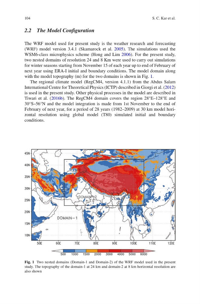
two nested domains of resolution 24 and 8 Km were used to carry out simulations
for winter seasons starting from November 15 of each year up to end of February of
next year using ERA-I initial and boundary conditions. The model domain along
with the model topography (m) for the two domains is shown in Fig. 1.
The regional climate model (RegCM4, version 4.1.1) from the Abdus Salam
International Centre for Theoretical Physics (ICTP) described in Giorgi et al. (2012)
is used in the present study. Other physical processes in the model are described in
Tiwari et al. (2016b). The RegCM4 domain covers the region 28°E–128°E and
30°S–56°N and the model integration is made from 1st November to the end of
February of next year, for a period of 28 years (1982–2009) at 30 km model horizontal resolution using global model (T80) simulated initial and boundary
conditions.
Fig. 1 Two nested domains (Domain-1 and Domain-2) of the WRF model used in the present
study. The topography of the domain-1 at 24 km and domain-2 at 8 km horizontal resolution are
also shown
S. C. Kar et al.
2.2 The Model Configuration
The WRF model used for present study is the weather research and forecasting
(WRF) model version 3.4.1 (Skamarock et al. 2005). The simulations used the
WSM6-class microphysics scheme (Hong and Lim 2006). For the present study,
two nested domains of resolution 24 and 8 Km were used to carry out simulations
for winter seasons starting from November 15 of each year up to end of February of
next year using ERA-I initial and boundary conditions. The model domain along
with the model topography (m) for the two domains is shown in Fig. 1.
The regional climate model (RegCM4, version 4.1.1) from the Abdus Salam
International Centre for Theoretical Physics (ICTP) described in Giorgi et al. (2012)
is used in the present study. Other physical processes in the model are described in
Tiwari et al. (2016b). The RegCM4 domain covers the region 28°E–128°E and
30°S–56°N and the model integration is made from 1st November to the end of
February of next year, for a period of 28 years (1982–2009) at 30 km model horizontal resolution using global model (T80) simulated initial and boundary
conditions.
Fig. 1 Two nested domains (Domain-1 and Domain-2) of the WRF model used in the present
study. The topography of the domain-1 at 24 km and domain-2 at 8 km horizontal resolution are
also shown
S. C. Kar et al.