

horizontal plane from a local origin at the instrument site. These maps also can be prepared using
a local Cartesian coordinate system with x- and yaxes in the local (horizontal) datum and the z-axis
vertical.
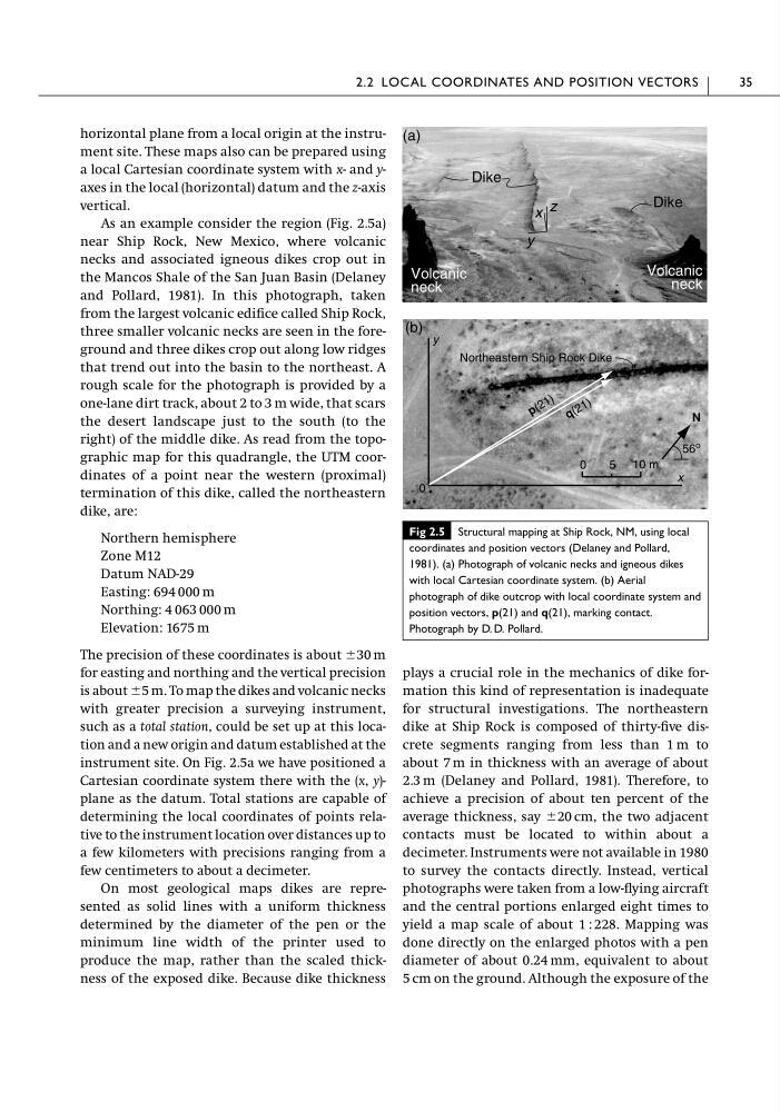
As an example consider the region (Fig. 2.5a)
near Ship Rock, New Mexico, where volcanic
necks and associated igneous dikes crop out in
the Mancos Shale of the San Juan Basin (Delaney
and Pollard, 1981). In this photograph, taken
from the largest volcanic edifice called Ship Rock,
three smaller volcanic necks are seen in the foreground and three dikes crop out along low ridges
that trend out into the basin to the northeast. A
rough scale for the photograph is provided by a
one-lane dirt track, about 2 to 3 m wide, that scars
the desert landscape just to the south (to the
right) of the middle dike. As read from the topographic map for this quadrangle, the UTM coordinates of a point near the western (proximal)
termination of this dike, called the northeastern
dike, are:
Northern hemisphere
Zone M12
Datum NAD-29
Easting: 694 000 m
Northing: 4 063 000 m
Elevation: 1675 m
The precision of these coordinates is about Ϯ30 m
for easting and northing and the vertical precision
is about Ϯ5 m. To map the dikes and volcanic necks
with greater precision a surveying instrument,
such as a total station, could be set up at this location and a new origin and datum established at the
instrument site. On Fig. 2.5a we have positioned a
Cartesian coordinate system there with the (x, y)plane as the datum. Total stations are capable of
determining the local coordinates of points relative to the instrument location over distances up to
a few kilometers with precisions ranging from a
few centimeters to about a decimeter.
On most geological maps dikes are represented as solid lines with a uniform thickness
determined by the diameter of the pen or the
minimum line width of the printer used to
produce the map, rather than the scaled thickness of the exposed dike. Because dike thickness
plays a crucial role in the mechanics of dike formation this kind of representation is inadequate
for structural investigations. The northeastern
dike at Ship Rock is composed of thirty-five discrete segments ranging from less than 1 m to
about 7 m in thickness with an average of about
2.3 m (Delaney and Pollard, 1981). Therefore, to
achieve a precision of about ten percent of the
average thickness, say Ϯ20 cm, the two adjacent
contacts must be located to within about a
decimeter. Instruments were not available in 1980
to survey the contacts directly. Instead, vertical
photographs were taken from a low-flying aircraft
and the central portions enlarged eight times to
yield a map scale of about 1 : 228. Mapping was
done directly on the enlarged photos with a pen
diameter of about 0.24 mm, equivalent to about
5 cm on the ground. Although the exposure of the
2.2 LOCAL COORDINATES AND POSITION VECTORS
35
x
y
z
Dike
Dike
Volcanic
neck
Volcanic
neck
(a)
y
x
N
Northeastern Ship Rock Dike
p ( 2 1 )
q ( 2 1 )
0
0
5 10 m
56 o
(b)
Fig 2.5 Structural mapping at Ship Rock, NM, using local
coordinates and position vectors (Delaney and Pollard,
1981). (a) Photograph of volcanic necks and igneous dikes
with local Cartesian coordinate system. (b) Aerial
photograph of dike outcrop with local coordinate system and
position vectors, p(21) and q(21), marking contact.
Photograph by D. D. Pollard.
a local Cartesian coordinate system with x- and yaxes in the local (horizontal) datum and the z-axis
vertical.
As an example consider the region (Fig. 2.5a)
near Ship Rock, New Mexico, where volcanic
necks and associated igneous dikes crop out in
the Mancos Shale of the San Juan Basin (Delaney
and Pollard, 1981). In this photograph, taken
from the largest volcanic edifice called Ship Rock,
three smaller volcanic necks are seen in the foreground and three dikes crop out along low ridges
that trend out into the basin to the northeast. A
rough scale for the photograph is provided by a
one-lane dirt track, about 2 to 3 m wide, that scars
the desert landscape just to the south (to the
right) of the middle dike. As read from the topographic map for this quadrangle, the UTM coordinates of a point near the western (proximal)
termination of this dike, called the northeastern
dike, are:
Northern hemisphere
Zone M12
Datum NAD-29
Easting: 694 000 m
Northing: 4 063 000 m
Elevation: 1675 m
The precision of these coordinates is about Ϯ30 m
for easting and northing and the vertical precision
is about Ϯ5 m. To map the dikes and volcanic necks
with greater precision a surveying instrument,
such as a total station, could be set up at this location and a new origin and datum established at the
instrument site. On Fig. 2.5a we have positioned a
Cartesian coordinate system there with the (x, y)plane as the datum. Total stations are capable of
determining the local coordinates of points relative to the instrument location over distances up to
a few kilometers with precisions ranging from a
few centimeters to about a decimeter.
On most geological maps dikes are represented as solid lines with a uniform thickness
determined by the diameter of the pen or the
minimum line width of the printer used to
produce the map, rather than the scaled thickness of the exposed dike. Because dike thickness
plays a crucial role in the mechanics of dike formation this kind of representation is inadequate
for structural investigations. The northeastern
dike at Ship Rock is composed of thirty-five discrete segments ranging from less than 1 m to
about 7 m in thickness with an average of about
2.3 m (Delaney and Pollard, 1981). Therefore, to
achieve a precision of about ten percent of the
average thickness, say Ϯ20 cm, the two adjacent
contacts must be located to within about a
decimeter. Instruments were not available in 1980
to survey the contacts directly. Instead, vertical
photographs were taken from a low-flying aircraft
and the central portions enlarged eight times to
yield a map scale of about 1 : 228. Mapping was
done directly on the enlarged photos with a pen
diameter of about 0.24 mm, equivalent to about
5 cm on the ground. Although the exposure of the
2.2 LOCAL COORDINATES AND POSITION VECTORS
35
x
y
z
Dike
Dike
Volcanic
neck
Volcanic
neck
(a)
y
x
N
Northeastern Ship Rock Dike
p ( 2 1 )
q ( 2 1 )
0
0
5 10 m
56 o
(b)
Fig 2.5 Structural mapping at Ship Rock, NM, using local
coordinates and position vectors (Delaney and Pollard,
1981). (a) Photograph of volcanic necks and igneous dikes
with local Cartesian coordinate system. (b) Aerial
photograph of dike outcrop with local coordinate system and
position vectors, p(21) and q(21), marking contact.
Photograph by D. D. Pollard.