

Latitude: 38Њ 45Ј N
Longitude: 123Њ 42Ј W
Elevation (mean sea level datum): 425 m
Note that the precision of the location given here
is only to the nearest degree and the elevation is
extrapolated from contours with 100 m intervals
(not very precise).
The convention in geodesy is to use a mathematical model for the Earth’s shape that is an
oblate ellipsoid: a three-dimensional surface
formed by rotating an ellipse about its minor axis.
If the semi-major and semi-minor axes of the
ellipse are called a and b, respectively, the compression or flattening of the ellipsoid at the poles
is defined as f ϭ (a Ϫ b)/a. The rotation of the Earth
does cause some extension of the equatorial
radius and some flattening at the poles so a Ͼ b,
and the semi-major axis is the radius of the equatorial circle of the ellipsoid. A standard model
used by geodesists is called the Geodetic Reference
System 1980 ellipsoid, or GRS-80 for short
(Hofmann-Wellenhof et al., 1997, p. 293). The
center of GRS-80 is located at the true center of the
Earth and the semi-minor axis is parallel to the
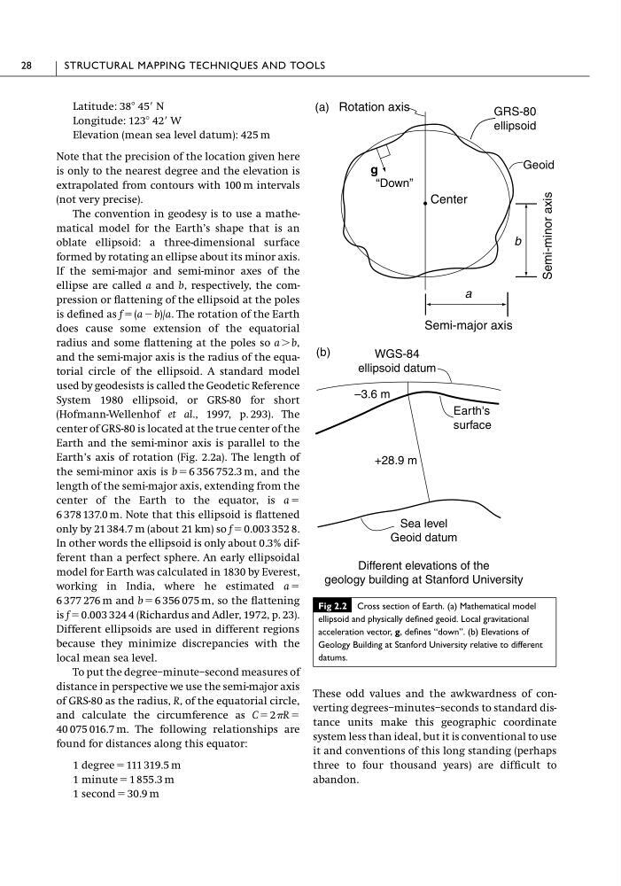
Earth’s axis of rotation (Fig. 2.2a). The length of
the semi-minor axis is b ϭ 6 356 752.3 m, and the
length of the semi-major axis, extending from the
center of the Earth to the equator, is a ϭ
6 378 137.0 m. Note that this ellipsoid is flattened
only by 21 384.7 m (about 21 km) so f ϭ 0.003 352 8.
In other words the ellipsoid is only about 0.3% different than a perfect sphere. An early ellipsoidal
model for Earth was calculated in 1830 by Everest,
working in India, where he estimated a ϭ
6 377 276 m and b ϭ 6 356 075 m, so the flattening
is f ϭ 0.003 324 4 (Richardus and Adler, 1972, p. 23).
Different ellipsoids are used in different regions
because they minimize discrepancies with the
local mean sea level.
To put the degree–minute–second measures of
distance in perspective we use the semi-major axis
of GRS-80 as the radius, R, of the equatorial circle,
and calculate the circumference as C ϭ 2R ϭ
40 075 016.7 m. The following relationships are
found for distances along this equator:
1 degree ϭ 111 319.5 m
1 minute ϭ 1 855.3 m
1 second ϭ 30.9 m
These odd values and the awkwardness of converting degrees–minutes–seconds to standard distance units make this geographic coordinate
system less than ideal, but it is conventional to use
it and conventions of this long standing (perhaps
three to four thousand years) are difficult to
abandon.
28
STRUCTURAL MAPPING TECHNIQUES AND TOOLS
(a)
Semi-major axis
Center
g
Rotation axis
Semi-minor axis
a
b
(b)
GRS-80
ellipsoid
Geoid
“Down”
WGS-84
ellipsoid datum
–3.6 m
Earth's
surface
+28.9 m
Sea level
Geoid datum
Different elevations of the
geology building at Stanford University
Fig 2.2 Cross section of Earth. (a) Mathematical model
ellipsoid and physically defined geoid. Local gravitational
acceleration vector, g, defines “down”. (b) Elevations of
Geology Building at Stanford University relative to different
datums.
Longitude: 123Њ 42Ј W
Elevation (mean sea level datum): 425 m
Note that the precision of the location given here
is only to the nearest degree and the elevation is
extrapolated from contours with 100 m intervals
(not very precise).
The convention in geodesy is to use a mathematical model for the Earth’s shape that is an
oblate ellipsoid: a three-dimensional surface
formed by rotating an ellipse about its minor axis.
If the semi-major and semi-minor axes of the
ellipse are called a and b, respectively, the compression or flattening of the ellipsoid at the poles
is defined as f ϭ (a Ϫ b)/a. The rotation of the Earth
does cause some extension of the equatorial
radius and some flattening at the poles so a Ͼ b,
and the semi-major axis is the radius of the equatorial circle of the ellipsoid. A standard model
used by geodesists is called the Geodetic Reference
System 1980 ellipsoid, or GRS-80 for short
(Hofmann-Wellenhof et al., 1997, p. 293). The
center of GRS-80 is located at the true center of the
Earth and the semi-minor axis is parallel to the
Earth’s axis of rotation (Fig. 2.2a). The length of
the semi-minor axis is b ϭ 6 356 752.3 m, and the
length of the semi-major axis, extending from the
center of the Earth to the equator, is a ϭ
6 378 137.0 m. Note that this ellipsoid is flattened
only by 21 384.7 m (about 21 km) so f ϭ 0.003 352 8.
In other words the ellipsoid is only about 0.3% different than a perfect sphere. An early ellipsoidal
model for Earth was calculated in 1830 by Everest,
working in India, where he estimated a ϭ
6 377 276 m and b ϭ 6 356 075 m, so the flattening
is f ϭ 0.003 324 4 (Richardus and Adler, 1972, p. 23).
Different ellipsoids are used in different regions
because they minimize discrepancies with the
local mean sea level.
To put the degree–minute–second measures of
distance in perspective we use the semi-major axis
of GRS-80 as the radius, R, of the equatorial circle,
and calculate the circumference as C ϭ 2R ϭ
40 075 016.7 m. The following relationships are
found for distances along this equator:
1 degree ϭ 111 319.5 m
1 minute ϭ 1 855.3 m
1 second ϭ 30.9 m
These odd values and the awkwardness of converting degrees–minutes–seconds to standard distance units make this geographic coordinate
system less than ideal, but it is conventional to use
it and conventions of this long standing (perhaps
three to four thousand years) are difficult to
abandon.
28
STRUCTURAL MAPPING TECHNIQUES AND TOOLS
(a)
Semi-major axis
Center
g
Rotation axis
Semi-minor axis
a
b
(b)
GRS-80
ellipsoid
Geoid
“Down”
WGS-84
ellipsoid datum
–3.6 m
Earth's
surface
+28.9 m
Sea level
Geoid datum
Different elevations of the
geology building at Stanford University
Fig 2.2 Cross section of Earth. (a) Mathematical model
ellipsoid and physically defined geoid. Local gravitational
acceleration vector, g, defines “down”. (b) Elevations of
Geology Building at Stanford University relative to different
datums.