

force to overcome the resistance to faulting. This
does not preclude the lateral growth of a sill, but
does preclude the development of the laccolith.
From this relationship Gilbert inferred that short
sills would be incapable of producing a structural
dome of the kind observed in the Henry
Mountains. On the other hand if the magma were
able to spread far enough laterally as a sill, the
driving force would equal the resisting force and,
in the next increment of growth, the fault would
develop and the overburden would begin to displace upward to form a laccolith.
Solving the equilibrium equation for the
radius of the piston, Gilbert found:
(1.2)
He noted the linear relationship between piston
radius, a, and depth of overburden, d, and inferred
that, for a given (positive) driving pressure, P m Ϫ
P w , and fault shear strength, S, magma must
spread to a greater radius at a greater depth in
order for the overburden to be pushed upward
along the fault. The second conjecture made
above (laccoliths with greater diameters should be
found lower in the stratigraphic sequence) is
a ϭ
2dS
P m Ϫ P w
correct according to this model for laccolith formation.
The conceptual and mechanical models formulated by Gilbert for laccolith formation provided him with a linear relationship between the
diameter of laccoliths and their depth of burial.
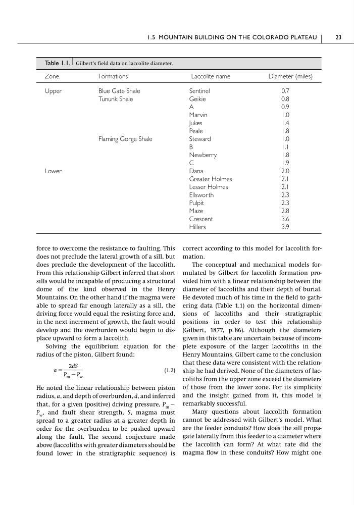
He devoted much of his time in the field to gathering data (Table 1.1) on the horizontal dimensions of laccoliths and their stratigraphic
positions in order to test this relationship
(Gilbert, 1877, p. 86). Although the diameters
given in this table are uncertain because of incomplete exposure of the larger laccoliths in the
Henry Mountains, Gilbert came to the conclusion
that these data were consistent with the relationship he had derived. None of the diameters of laccoliths from the upper zone exceed the diameters
of those from the lower zone. For its simplicity
and the insight gained from it, this model is
remarkably successful.
Many questions about laccolith formation
cannot be addressed with Gilbert’s model. What
are the feeder conduits? How does the sill propagate laterally from this feeder to a diameter where
the laccolith can form? At what rate did the
magma flow in these conduits? How might one
1.5 MOUNTAIN BUILDING ON THE COLORADO PLATEAU
23
Table 1.1. Gilbert’s field data on laccolite diameter.
Zone
Formations
Laccolite name
Diameter (miles)
Upper
Blue Gate Shale
Sentinel
0.7
Tununk Shale
Geikie
0.8
A
0.9
Marvin
1.0
Jukes
1.4
Peale
1.8
Flaming Gorge Shale
Steward
1.0
B
1.1
Newberry
1.8
C
1.9
Lower
Dana
2.0
Greater Holmes
2.1
Lesser Holmes
2.1
Ellsworth
2.3
Pulpit
2.3
Maze
2.8
Crescent
3.6
Hillers
3.9
does not preclude the lateral growth of a sill, but
does preclude the development of the laccolith.
From this relationship Gilbert inferred that short
sills would be incapable of producing a structural
dome of the kind observed in the Henry
Mountains. On the other hand if the magma were
able to spread far enough laterally as a sill, the
driving force would equal the resisting force and,
in the next increment of growth, the fault would
develop and the overburden would begin to displace upward to form a laccolith.
Solving the equilibrium equation for the
radius of the piston, Gilbert found:
(1.2)
He noted the linear relationship between piston
radius, a, and depth of overburden, d, and inferred
that, for a given (positive) driving pressure, P m Ϫ
P w , and fault shear strength, S, magma must
spread to a greater radius at a greater depth in
order for the overburden to be pushed upward
along the fault. The second conjecture made
above (laccoliths with greater diameters should be
found lower in the stratigraphic sequence) is
a ϭ
2dS
P m Ϫ P w
correct according to this model for laccolith formation.
The conceptual and mechanical models formulated by Gilbert for laccolith formation provided him with a linear relationship between the
diameter of laccoliths and their depth of burial.
He devoted much of his time in the field to gathering data (Table 1.1) on the horizontal dimensions of laccoliths and their stratigraphic
positions in order to test this relationship
(Gilbert, 1877, p. 86). Although the diameters
given in this table are uncertain because of incomplete exposure of the larger laccoliths in the
Henry Mountains, Gilbert came to the conclusion
that these data were consistent with the relationship he had derived. None of the diameters of laccoliths from the upper zone exceed the diameters
of those from the lower zone. For its simplicity
and the insight gained from it, this model is
remarkably successful.
Many questions about laccolith formation
cannot be addressed with Gilbert’s model. What
are the feeder conduits? How does the sill propagate laterally from this feeder to a diameter where
the laccolith can form? At what rate did the
magma flow in these conduits? How might one
1.5 MOUNTAIN BUILDING ON THE COLORADO PLATEAU
23
Table 1.1. Gilbert’s field data on laccolite diameter.
Zone
Formations
Laccolite name
Diameter (miles)
Upper
Blue Gate Shale
Sentinel
0.7
Tununk Shale
Geikie
0.8
A
0.9
Marvin
1.0
Jukes
1.4
Peale
1.8
Flaming Gorge Shale
Steward
1.0
B
1.1
Newberry
1.8
C
1.9
Lower
Dana
2.0
Greater Holmes
2.1
Lesser Holmes
2.1
Ellsworth
2.3
Pulpit
2.3
Maze
2.8
Crescent
3.6
Hillers
3.9