

8.1.1 A field test at Ship Rock, New
Mexico
The “apparatus” for this field test is an igneous
dike that crops out near the base of a volcanic
edifice called Ship Rock in northwestern New
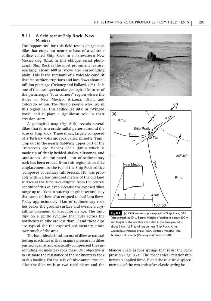
Mexico (Fig. 8.1a). In this oblique aerial photograph Ship Rock is the most prominent feature,
reaching about 600 m above the surrounding
plain. This is the remnant of a volcanic conduit
that fed surface eruptions and lava flows about 30
million years ago (Delaney and Pollard, 1981). It is
one of the most spectacular geological features of
the picturesque “four corners” region where the
states of New Mexico, Arizona, Utah, and
Colorado adjoin. The Navajo people who live in
this region call this edifice Tse Bitai or “Winged
Rock” and it plays a significant role in their
creation story.
A geological map (Fig. 8.1b) reveals several
dikes that form a crude radial pattern around the
base of Ship Rock. These dikes, largely composed
of a Tertiary volcanic rock called minette (Tmn),
crop out in the nearly flat-lying upper part of the
Cretaceous age Mancos Shale (Kmu) which is
made up of thinly bedded shales, siltstones, and
sandstones. An estimated 1 km of sedimentary
rock has been eroded from this region since dike
emplacement, so the top of the Ship Rock edifice
(composed of Tertiary tuff breccia, Ttb) was probably within a few hundred meters of the old land
surface at the time lava erupted from the central
conduit of this volcano. Because the exposed dikes
range up to 10 km in outcrop length it seems likely
that some of them also erupted to feed lava flows.
Today approximately 1 km of sedimentary rock
lies below the ground surface and overlie a crystalline basement of Precambrian age. The limb
dips on a gentle syncline that cuts across the
northeastern dike are less than 5Њ and these dips
are typical for the exposed sedimentary strata
over much of the area.
The basic idea behind our use of dikes as natural
testing machines is that magma pressure in dikes
pushed against and elastically compressed the surrounding sedimentary rock mass. Our objective is
to estimate the resistance of the sedimentary rock
to this loading. For the sake of this example we idealize the dike walls as two rigid plates and the
Mancos Shale as four springs that resist the compression (Fig. 8.2a). The mechanical relationship
between applied force, F, and the relative displacement, u, of the two ends of an elastic spring is:
8.1 ESTIMATING ROCK PROPERTIES FROM FIELD TESTS
289
0
4 km
3
2
1
New Mexico
36 o 40'
T
m
n
Tmn
T m n
Ttb
Kmu
Kmu
Ship Rock
(b)
(a)
108 o 50'
Fig 8.1 (a) Oblique aerial photograph of Ship Rock, NM
(photograph by D. L. Baars). Height of edifice is about 600 m
and length of the northeastern dike in the foreground is
about 3 km. (b) Map of region near Ship Rock: Kmu,
Cretaceous Mancos Shale; Tmn, Tertiary minette; Ttb,
Tertiary tuff breccia (Delaney and Pollard, 1981).
Mexico
The “apparatus” for this field test is an igneous
dike that crops out near the base of a volcanic
edifice called Ship Rock in northwestern New
Mexico (Fig. 8.1a). In this oblique aerial photograph Ship Rock is the most prominent feature,
reaching about 600 m above the surrounding
plain. This is the remnant of a volcanic conduit
that fed surface eruptions and lava flows about 30
million years ago (Delaney and Pollard, 1981). It is
one of the most spectacular geological features of
the picturesque “four corners” region where the
states of New Mexico, Arizona, Utah, and
Colorado adjoin. The Navajo people who live in
this region call this edifice Tse Bitai or “Winged
Rock” and it plays a significant role in their
creation story.
A geological map (Fig. 8.1b) reveals several
dikes that form a crude radial pattern around the
base of Ship Rock. These dikes, largely composed
of a Tertiary volcanic rock called minette (Tmn),
crop out in the nearly flat-lying upper part of the
Cretaceous age Mancos Shale (Kmu) which is
made up of thinly bedded shales, siltstones, and
sandstones. An estimated 1 km of sedimentary
rock has been eroded from this region since dike
emplacement, so the top of the Ship Rock edifice
(composed of Tertiary tuff breccia, Ttb) was probably within a few hundred meters of the old land
surface at the time lava erupted from the central
conduit of this volcano. Because the exposed dikes
range up to 10 km in outcrop length it seems likely
that some of them also erupted to feed lava flows.
Today approximately 1 km of sedimentary rock
lies below the ground surface and overlie a crystalline basement of Precambrian age. The limb
dips on a gentle syncline that cuts across the
northeastern dike are less than 5Њ and these dips
are typical for the exposed sedimentary strata
over much of the area.
The basic idea behind our use of dikes as natural
testing machines is that magma pressure in dikes
pushed against and elastically compressed the surrounding sedimentary rock mass. Our objective is
to estimate the resistance of the sedimentary rock
to this loading. For the sake of this example we idealize the dike walls as two rigid plates and the
Mancos Shale as four springs that resist the compression (Fig. 8.2a). The mechanical relationship
between applied force, F, and the relative displacement, u, of the two ends of an elastic spring is:
8.1 ESTIMATING ROCK PROPERTIES FROM FIELD TESTS
289
0
4 km
3
2
1
New Mexico
36 o 40'
T
m
n
Tmn
T m n
Ttb
Kmu
Kmu
Ship Rock
(b)
(a)
108 o 50'
Fig 8.1 (a) Oblique aerial photograph of Ship Rock, NM
(photograph by D. L. Baars). Height of edifice is about 600 m
and length of the northeastern dike in the foreground is
about 3 km. (b) Map of region near Ship Rock: Kmu,
Cretaceous Mancos Shale; Tmn, Tertiary minette; Ttb,
Tertiary tuff breccia (Delaney and Pollard, 1981).