

568
R. B˘ atina¸ s et al.
Table 16.11 Characteristic volumes of the reservoirs from the Upper basin of Cris , ul Repede river
No.
Reservoir
Characteristic volumes (mil m 3 )
Total
Raw
Useful
Mitigation
1.
Floroiu
124
112
100
6
2.
Les , u
32.8
28.3
–
–
After Horvath [30]
The hydrotechnical complex Dr˘ agan-Iada can be divided in two components: the
Dr˘ agan hyrotechnical assembly with the Remet , i, Munteni I ¸
si Munteni II hydropower
plants, and on the other hand the Les , u hydrotechnical assembly with Les , u hydropower
plant and its associated dam. The most important function is the capitalization of
hydropower potential of Dr˘ agan, Iada and S˘ acuieu rivers
Dr˘ agan dam, was completed at the end of 1984, while Floroiu reservoir (290 ha)
has reached the 84 m height of retention in May of 1985. The Les , u dam and reservoir
(120 ha) are located on Iada river, at about 7 km upstream of the Remet , i village, the
dam being made during the years 1969–1973.
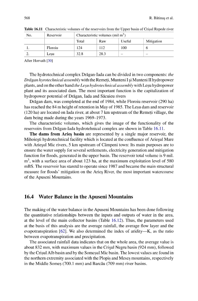
The characteristic volumes, which gives the image of the functionality of the
reservoirs from Dr˘ agan-Iada hydrotehnical complex are shown in Table 16.11.
The dams from Arie¸ s basin are represented by a single major reservoir, the
Mihoie¸ sti hydrotechnical facility which is located at the confluence of Arie¸ sul Mare
with Arie¸ sul Mic rivers, 5 km upstream of Câmpeni town: Its main purposes are to
ensure the water supply for several settlements, electricity generation and mitigation
function for floods, generated in the upper basin. The reservoir total volume is 9 mil.
m
3 , with a surface area of about 123 ha, at the maximum exploitation level of 580
mBS. The reservoir has staretd to operate since 1987 and became the main structural
measure for floods’ mitigation on the Arie¸ s River, the most important watercourse
of the Apuseni Mountains.
16.4 Water Balance in the Apuseni Mountains
The making of the water balance in the Apuseni Mountains has been done following
the quantitative relationships between the inputs and outputs of water in the area,
at the level of the main collector basins (Table 16.12). Thus, the parameters used
at the basis of this analysis are the average rainfall, the average flow layer and the
evapotranspiration [62]. We also determined the index of aridity—K, as the ratio
between evapotranspiration and precipitation.
The associated rainfall data indicates that on the whole area, the average value is
about 832 mm, with maximum values in the Cri¸ sul Negru basin (924 mm), followed
by the Cris , ul Alb basin and by the Somes , ul Mic basin. The lowest values are found in
the northern extremity associated with the Plopis , and Meses , mountains, respectively
in the Middle Somes , (700.1 mm) and Barc˘ au (709 mm) river basins.
R. B˘ atina¸ s et al.
Table 16.11 Characteristic volumes of the reservoirs from the Upper basin of Cris , ul Repede river
No.
Reservoir
Characteristic volumes (mil m 3 )
Total
Raw
Useful
Mitigation
1.
Floroiu
124
112
100
6
2.
Les , u
32.8
28.3
–
–
After Horvath [30]
The hydrotechnical complex Dr˘ agan-Iada can be divided in two components: the
Dr˘ agan hyrotechnical assembly with the Remet , i, Munteni I ¸
si Munteni II hydropower
plants, and on the other hand the Les , u hydrotechnical assembly with Les , u hydropower
plant and its associated dam. The most important function is the capitalization of
hydropower potential of Dr˘ agan, Iada and S˘ acuieu rivers
Dr˘ agan dam, was completed at the end of 1984, while Floroiu reservoir (290 ha)
has reached the 84 m height of retention in May of 1985. The Les , u dam and reservoir
(120 ha) are located on Iada river, at about 7 km upstream of the Remet , i village, the
dam being made during the years 1969–1973.
The characteristic volumes, which gives the image of the functionality of the
reservoirs from Dr˘ agan-Iada hydrotehnical complex are shown in Table 16.11.
The dams from Arie¸ s basin are represented by a single major reservoir, the
Mihoie¸ sti hydrotechnical facility which is located at the confluence of Arie¸ sul Mare
with Arie¸ sul Mic rivers, 5 km upstream of Câmpeni town: Its main purposes are to
ensure the water supply for several settlements, electricity generation and mitigation
function for floods, generated in the upper basin. The reservoir total volume is 9 mil.
m
3 , with a surface area of about 123 ha, at the maximum exploitation level of 580
mBS. The reservoir has staretd to operate since 1987 and became the main structural
measure for floods’ mitigation on the Arie¸ s River, the most important watercourse
of the Apuseni Mountains.
16.4 Water Balance in the Apuseni Mountains
The making of the water balance in the Apuseni Mountains has been done following
the quantitative relationships between the inputs and outputs of water in the area,
at the level of the main collector basins (Table 16.12). Thus, the parameters used
at the basis of this analysis are the average rainfall, the average flow layer and the
evapotranspiration [62]. We also determined the index of aridity—K, as the ratio
between evapotranspiration and precipitation.
The associated rainfall data indicates that on the whole area, the average value is
about 832 mm, with maximum values in the Cri¸ sul Negru basin (924 mm), followed
by the Cris , ul Alb basin and by the Somes , ul Mic basin. The lowest values are found in
the northern extremity associated with the Plopis , and Meses , mountains, respectively
in the Middle Somes , (700.1 mm) and Barc˘ au (709 mm) river basins.