

16 Water Resources from Apuseni Mountains …
557
administration institutions, which manage the hydrographic resources in the analyzed
area.
The distribution of run-off volumes during the year shows large variations in close
connection with the evolution of climatic elements. As a rule, the largest volume of
water flows in the spring season, with the melting of snow and the occurrence of
specific rains (40–50% and the maximum flow is recorded during April). Minimum
values are recorded usually in winter in specific conditions caused by negative temperatures involving the blocking of water volumes either in the form of snow or
caught in the form of ice in the riverbed. In some situations, can be identified in a
small water period even in autumn, especially in depression areas. Depending on the
climatic factors, the altitude of the hydrographic basins taken into account and the
position on the two sides of the mountains, several types of the regime can be highlighted: Western Pericarpathic, Transylvanian Pericarpathic, Western Carpathic and
Transylvanian Carpathic. The classification and description of hydrological regimes
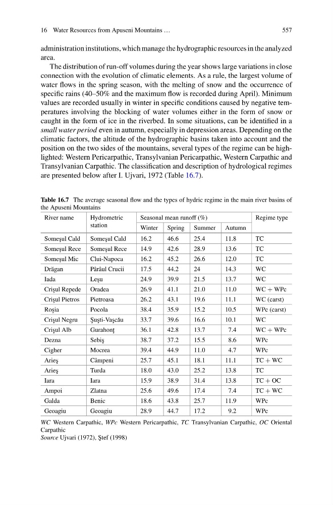
are presented below after I. Ujvari, 1972 (Table 16.7).
Table 16.7 The average seasonal flow and the types of hydric regime in the main river basins of
the Apuseni Mountains
River name
Hydrometric
station
Seasonal mean runoff (%)
Regime type
Winter Spring Summer Autumn
Some¸ sul Cald
Some¸ sul Cald
16.2
46.6
25.4
11.8
TC
Some¸ sul Rece Some¸ sul Rece
14.9
42.6
28.9
13.6
TC
Some¸ sul Mic
Clui-Napoca
16.2
45.2
26.6
12.0
TC
Dr˘ agan
Pârâul Crucii
17.5
44.2
24
14.3
WC
Iada
Le¸ su
24.9
39.9
21.5
13.7
WC
Cri¸ sul Repede Oradea
26.9
41.1
21.0
11.0
WC + WPc
Cri¸ sul Pietros
Pietroasa
26.2
43.1
19.6
11.1
WC (carst)
Ro¸ sia
Pocola
38.4
35.9
15.2
10.5
WPc (carst)
Cri¸ sul Negru
¸
Su¸ sti-Va¸ sc˘ au
33.7
39.6
16.6
10.1
WC
Cri¸ sul Alb
Gurahon¸ t
36.1
42.8
13.7
7.4
WC + WPc
Dezna
Sebi¸ s
38.7
37.2
15.5
8.6
WPc
Cigher
Mocrea
39.4
44.9
11.0
4.7
WPc
Arie¸ s
Câmpeni
25.7
45.1
18.1
11.1
TC + WC
Arie¸ s
Turda
18.0
43.0
25.2
13.8
TC
Iara
Iara
15.9
38.9
31.4
13.8
TC + OC
Ampoi
Zlatna
25.6
49.6
17.4
7.4
TC + WC
Galda
Benic
18.6
43.8
25.7
11.9
WPc
Geoagiu
Geoagiu
28.9
44.7
17.2
9.2
WPc
WC Western Carpathic, WPc Western Pericarpathic, TC Transylvanian Carpathic, OC Oriental
Carpathic
Source Ujvari (1972), ¸
Stef (1998)
557
administration institutions, which manage the hydrographic resources in the analyzed
area.
The distribution of run-off volumes during the year shows large variations in close
connection with the evolution of climatic elements. As a rule, the largest volume of
water flows in the spring season, with the melting of snow and the occurrence of
specific rains (40–50% and the maximum flow is recorded during April). Minimum
values are recorded usually in winter in specific conditions caused by negative temperatures involving the blocking of water volumes either in the form of snow or
caught in the form of ice in the riverbed. In some situations, can be identified in a
small water period even in autumn, especially in depression areas. Depending on the
climatic factors, the altitude of the hydrographic basins taken into account and the
position on the two sides of the mountains, several types of the regime can be highlighted: Western Pericarpathic, Transylvanian Pericarpathic, Western Carpathic and
Transylvanian Carpathic. The classification and description of hydrological regimes
are presented below after I. Ujvari, 1972 (Table 16.7).
Table 16.7 The average seasonal flow and the types of hydric regime in the main river basins of
the Apuseni Mountains
River name
Hydrometric
station
Seasonal mean runoff (%)
Regime type
Winter Spring Summer Autumn
Some¸ sul Cald
Some¸ sul Cald
16.2
46.6
25.4
11.8
TC
Some¸ sul Rece Some¸ sul Rece
14.9
42.6
28.9
13.6
TC
Some¸ sul Mic
Clui-Napoca
16.2
45.2
26.6
12.0
TC
Dr˘ agan
Pârâul Crucii
17.5
44.2
24
14.3
WC
Iada
Le¸ su
24.9
39.9
21.5
13.7
WC
Cri¸ sul Repede Oradea
26.9
41.1
21.0
11.0
WC + WPc
Cri¸ sul Pietros
Pietroasa
26.2
43.1
19.6
11.1
WC (carst)
Ro¸ sia
Pocola
38.4
35.9
15.2
10.5
WPc (carst)
Cri¸ sul Negru
¸
Su¸ sti-Va¸ sc˘ au
33.7
39.6
16.6
10.1
WC
Cri¸ sul Alb
Gurahon¸ t
36.1
42.8
13.7
7.4
WC + WPc
Dezna
Sebi¸ s
38.7
37.2
15.5
8.6
WPc
Cigher
Mocrea
39.4
44.9
11.0
4.7
WPc
Arie¸ s
Câmpeni
25.7
45.1
18.1
11.1
TC + WC
Arie¸ s
Turda
18.0
43.0
25.2
13.8
TC
Iara
Iara
15.9
38.9
31.4
13.8
TC + OC
Ampoi
Zlatna
25.6
49.6
17.4
7.4
TC + WC
Galda
Benic
18.6
43.8
25.7
11.9
WPc
Geoagiu
Geoagiu
28.9
44.7
17.2
9.2
WPc
WC Western Carpathic, WPc Western Pericarpathic, TC Transylvanian Carpathic, OC Oriental
Carpathic
Source Ujvari (1972), ¸
Stef (1998)