

546
R. B˘ atina¸ s et al.
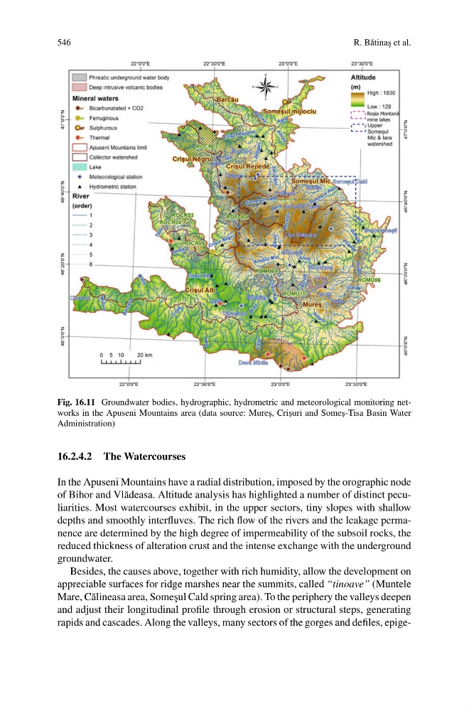
Fig. 16.11 Groundwater bodies, hydrographic, hydrometric and meteorological monitoring networks in the Apuseni Mountains area (data source: Mures , , Cris , uri and Somes , -Tisa Basin Water
Administration)
16.2.4.2 The Watercourses
In the Apuseni Mountains have a radial distribution, imposed by the orographic node
of Bihor and Vl˘ adeasa. Altitude analysis has highlighted a number of distinct peculiarities. Most watercourses exhibit, in the upper sectors, tiny slopes with shallow
depths and smoothly interfluves. The rich flow of the rivers and the leakage permanence are determined by the high degree of impermeability of the subsoil rocks, the
reduced thickness of alteration crust and the intense exchange with the underground
groundwater.
Besides, the causes above, together with rich humidity, allow the development on
appreciable surfaces for ridge marshes near the summits, called “tinoave” (Muntele
Mare, C˘ alineasa area, Some¸ sul Cald spring area). To the periphery the valleys deepen
and adjust their longitudinal profile through erosion or structural steps, generating
rapids and cascades. Along the valleys, many sectors of the gorges and defiles, epige-
R. B˘ atina¸ s et al.
Fig. 16.11 Groundwater bodies, hydrographic, hydrometric and meteorological monitoring networks in the Apuseni Mountains area (data source: Mures , , Cris , uri and Somes , -Tisa Basin Water
Administration)
16.2.4.2 The Watercourses
In the Apuseni Mountains have a radial distribution, imposed by the orographic node
of Bihor and Vl˘ adeasa. Altitude analysis has highlighted a number of distinct peculiarities. Most watercourses exhibit, in the upper sectors, tiny slopes with shallow
depths and smoothly interfluves. The rich flow of the rivers and the leakage permanence are determined by the high degree of impermeability of the subsoil rocks, the
reduced thickness of alteration crust and the intense exchange with the underground
groundwater.
Besides, the causes above, together with rich humidity, allow the development on
appreciable surfaces for ridge marshes near the summits, called “tinoave” (Muntele
Mare, C˘ alineasa area, Some¸ sul Cald spring area). To the periphery the valleys deepen
and adjust their longitudinal profile through erosion or structural steps, generating
rapids and cascades. Along the valleys, many sectors of the gorges and defiles, epige-