

12 Water Resources from Romanian Upper Tisa Basin
423
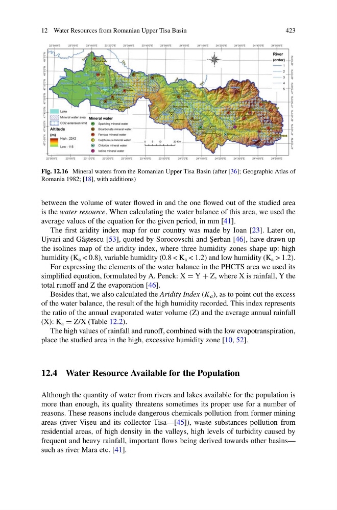
Fig. 12.16 Mineral waters from the Romanian Upper Tisa Basin (after [36]; Geographic Atlas of
Romania 1982; [18], with additions)
between the volume of water flowed in and the one flowed out of the studied area
is the water resource. When calculating the water balance of this area, we used the
average values of the equation for the given period, in mm [41].
The first aridity index map for our country was made by Ioan [23]. Later on,
Ujvari and Gâs , tescu [53], quoted by Sorocovschi and ¸
Serban [46], have drawn up
the isolines map of the aridity index, where three humidity zones shape up: high
humidity (K a < 0.8), variable humidity (0.8 < K a < 1.2) and low humidity (K a > 1.2).
For expressing the elements of the water balance in the PHCTS area we used its
simplified equation, formulated by A. Penck: X = Y + Z, where X is rainfall, Y the
total runoff and Z the evaporation [46].
Besides that, we also calculated the Aridity Index (K a ), as to point out the excess
of the water balance, the result of the high humidity recorded. This index represents
the ratio of the annual evaporated water volume (Z) and the average annual rainfall
(X): K a = Z/X (Table 12.2).
The high values of rainfall and runoff, combined with the low evapotranspiration,
place the studied area in the high, excessive humidity zone [10, 52].
12.4 Water Resource Available for the Population
Although the quantity of water from rivers and lakes available for the population is
more than enough, its quality threatens sometimes its proper use for a number of
reasons. These reasons include dangerous chemicals pollution from former mining
areas (river Vis , eu and its collector Tisa—[45]), waste substances pollution from
residential areas, of high density in the valleys, high levels of turbidity caused by
frequent and heavy rainfall, important flows being derived towards other basins—
such as river Mara etc. [41].
423
Fig. 12.16 Mineral waters from the Romanian Upper Tisa Basin (after [36]; Geographic Atlas of
Romania 1982; [18], with additions)
between the volume of water flowed in and the one flowed out of the studied area
is the water resource. When calculating the water balance of this area, we used the
average values of the equation for the given period, in mm [41].
The first aridity index map for our country was made by Ioan [23]. Later on,
Ujvari and Gâs , tescu [53], quoted by Sorocovschi and ¸
Serban [46], have drawn up
the isolines map of the aridity index, where three humidity zones shape up: high
humidity (K a < 0.8), variable humidity (0.8 < K a < 1.2) and low humidity (K a > 1.2).
For expressing the elements of the water balance in the PHCTS area we used its
simplified equation, formulated by A. Penck: X = Y + Z, where X is rainfall, Y the
total runoff and Z the evaporation [46].
Besides that, we also calculated the Aridity Index (K a ), as to point out the excess
of the water balance, the result of the high humidity recorded. This index represents
the ratio of the annual evaporated water volume (Z) and the average annual rainfall
(X): K a = Z/X (Table 12.2).
The high values of rainfall and runoff, combined with the low evapotranspiration,
place the studied area in the high, excessive humidity zone [10, 52].
12.4 Water Resource Available for the Population
Although the quantity of water from rivers and lakes available for the population is
more than enough, its quality threatens sometimes its proper use for a number of
reasons. These reasons include dangerous chemicals pollution from former mining
areas (river Vis , eu and its collector Tisa—[45]), waste substances pollution from
residential areas, of high density in the valleys, high levels of turbidity caused by
frequent and heavy rainfall, important flows being derived towards other basins—
such as river Mara etc. [41].