

314
L. Zaharia et al.
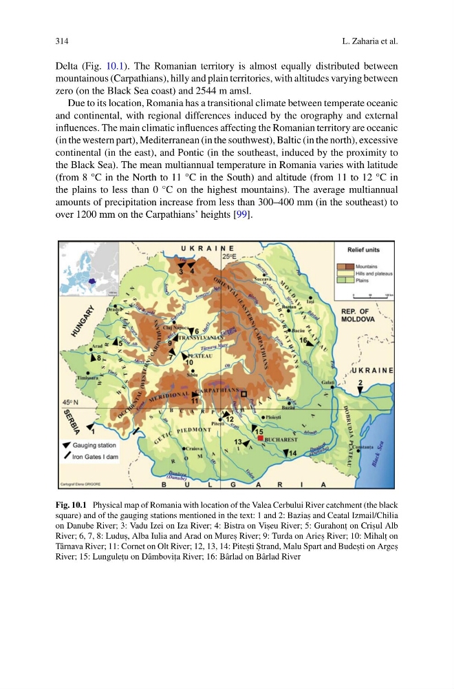
Delta (Fig. 10.1). The Romanian territory is almost equally distributed between
mountainous (Carpathians), hilly and plain territories, with altitudes varying between
zero (on the Black Sea coast) and 2544 m amsl.
Due to its location, Romania has a transitional climate between temperate oceanic
and continental, with regional differences induced by the orography and external
influences. The main climatic influences affecting the Romanian territory are oceanic
(in the western part), Mediterranean (in the southwest), Baltic (in the north), excessive
continental (in the east), and Pontic (in the southeast, induced by the proximity to
the Black Sea). The mean multiannual temperature in Romania varies with latitude
(from 8 °C in the North to 11 °C in the South) and altitude (from 11 to 12 °C in
the plains to less than 0 °C on the highest mountains). The average multiannual
amounts of precipitation increase from less than 300–400 mm (in the southeast) to
over 1200 mm on the Carpathians’ heights [99].
Fig. 10.1 Physical map of Romania with location of the Valea Cerbului River catchment (the black
square) and of the gauging stations mentioned in the text: 1 and 2: Bazias , and Ceatal Izmail/Chilia
on Danube River; 3: Vadu Izei on Iza River; 4: Bistra on Vis , eu River; 5: Gurahont , on Cris , ul Alb
River; 6, 7, 8: Ludus , , Alba Iulia and Arad on Mures , River; 9: Turda on Aries , River; 10: Mihalt , on
Târnava River; 11: Cornet on Olt River; 12, 13, 14: Pites , ti S , trand, Malu Spart and Budes , ti on Arges ,
River; 15: Lungulet , u on Dâmbovit , a River; 16: Bârlad on Bârlad River
L. Zaharia et al.
Delta (Fig. 10.1). The Romanian territory is almost equally distributed between
mountainous (Carpathians), hilly and plain territories, with altitudes varying between
zero (on the Black Sea coast) and 2544 m amsl.
Due to its location, Romania has a transitional climate between temperate oceanic
and continental, with regional differences induced by the orography and external
influences. The main climatic influences affecting the Romanian territory are oceanic
(in the western part), Mediterranean (in the southwest), Baltic (in the north), excessive
continental (in the east), and Pontic (in the southeast, induced by the proximity to
the Black Sea). The mean multiannual temperature in Romania varies with latitude
(from 8 °C in the North to 11 °C in the South) and altitude (from 11 to 12 °C in
the plains to less than 0 °C on the highest mountains). The average multiannual
amounts of precipitation increase from less than 300–400 mm (in the southeast) to
over 1200 mm on the Carpathians’ heights [99].
Fig. 10.1 Physical map of Romania with location of the Valea Cerbului River catchment (the black
square) and of the gauging stations mentioned in the text: 1 and 2: Bazias , and Ceatal Izmail/Chilia
on Danube River; 3: Vadu Izei on Iza River; 4: Bistra on Vis , eu River; 5: Gurahont , on Cris , ul Alb
River; 6, 7, 8: Ludus , , Alba Iulia and Arad on Mures , River; 9: Turda on Aries , River; 10: Mihalt , on
Târnava River; 11: Cornet on Olt River; 12, 13, 14: Pites , ti S , trand, Malu Spart and Budes , ti on Arges ,
River; 15: Lungulet , u on Dâmbovit , a River; 16: Bârlad on Bârlad River