

8 Romanian Danube River Floodplain …
263
landscape modification. Geosystems can evolve between three defining states. The
first one represents the relationships of imbalances between components due to natural or anthropogenic causes. The second one represents the disequilibrium between
the constituent elements and the relations between them being artificialized by the
effect of anthropic activity. And the third one represents the equilibrium relations
between ecological support and biological exploitation (morpho-structural stability
of the components). These three “states” cause the degradation of the ecological
support and/or biological exploitation. The effects then being transmitted, mutually,
between all the components [18, 50, 61, 73–75].
The analyzes allowed for the identification of the stability phase of the relief due to
the absence of erosion under the conditions of a permanent vegetation layer present
on the entire unspoiled surface of the Danube meadows. The areas that include zone
of urban/rural localities as the phase of instability in the evolution of the relief due
to erosion, in the absence of a permanent vegetation layer, are characteristic of the
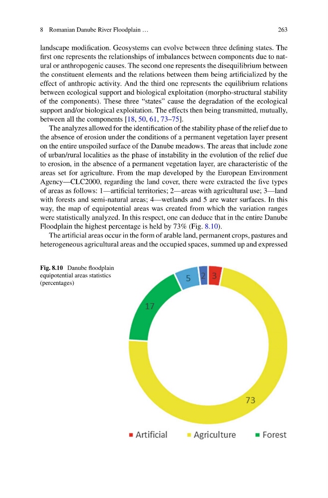
areas set for agriculture. From the map developed by the European Environment
Agency—CLC2000, regarding the land cover, there were extracted the five types
of areas as follows: 1—artificial territories; 2—areas with agricultural use; 3—land
with forests and semi-natural areas; 4—wetlands and 5 are water surfaces. In this
way, the map of equipotential areas was created from which the variation ranges
were statistically analyzed. In this respect, one can deduce that in the entire Danube
Floodplain the highest percentage is held by 73% (Fig. 8.10).
The artificial areas occur in the form of arable land, permanent crops, pastures and
heterogeneous agricultural areas and the occupied spaces, summed up and expressed
Fig. 8.10 Danube floodplain
equipotential areas statistics
(percentages)
263
landscape modification. Geosystems can evolve between three defining states. The
first one represents the relationships of imbalances between components due to natural or anthropogenic causes. The second one represents the disequilibrium between
the constituent elements and the relations between them being artificialized by the
effect of anthropic activity. And the third one represents the equilibrium relations
between ecological support and biological exploitation (morpho-structural stability
of the components). These three “states” cause the degradation of the ecological
support and/or biological exploitation. The effects then being transmitted, mutually,
between all the components [18, 50, 61, 73–75].
The analyzes allowed for the identification of the stability phase of the relief due to
the absence of erosion under the conditions of a permanent vegetation layer present
on the entire unspoiled surface of the Danube meadows. The areas that include zone
of urban/rural localities as the phase of instability in the evolution of the relief due
to erosion, in the absence of a permanent vegetation layer, are characteristic of the
areas set for agriculture. From the map developed by the European Environment
Agency—CLC2000, regarding the land cover, there were extracted the five types
of areas as follows: 1—artificial territories; 2—areas with agricultural use; 3—land
with forests and semi-natural areas; 4—wetlands and 5 are water surfaces. In this
way, the map of equipotential areas was created from which the variation ranges
were statistically analyzed. In this respect, one can deduce that in the entire Danube
Floodplain the highest percentage is held by 73% (Fig. 8.10).
The artificial areas occur in the form of arable land, permanent crops, pastures and
heterogeneous agricultural areas and the occupied spaces, summed up and expressed
Fig. 8.10 Danube floodplain
equipotential areas statistics
(percentages)