

172
A. Constantin and C. St. Nitescu
The maximum volume of water usually occurs at the end of winter and the beginning of spring (February–April), and the minimum at the end of the autumn and
the beginning of winter (November–January) when the average is 33% and 17–18%
eastern annual volume of the county [21].
In the Dobrogea hydrographic space, including the Danube Delta, a total of 75
waterbodies of natural lakes have been identified, out of which 17 are monitored.
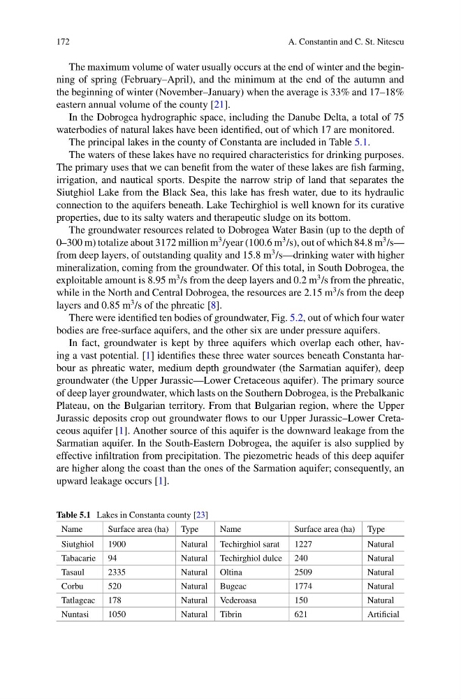
The principal lakes in the county of Constanta are included in Table 5.1.
The waters of these lakes have no required characteristics for drinking purposes.
The primary uses that we can benefit from the water of these lakes are fish farming,
irrigation, and nautical sports. Despite the narrow strip of land that separates the
Siutghiol Lake from the Black Sea, this lake has fresh water, due to its hydraulic
connection to the aquifers beneath. Lake Techirghiol is well known for its curative
properties, due to its salty waters and therapeutic sludge on its bottom.
The groundwater resources related to Dobrogea Water Basin (up to the depth of
0–300 m) totalize about 3172 million m
3 /year (100.6 m
3 /s), out of which 84.8 m
3 /s—
from deep layers, of outstanding quality and 15.8 m
3 /s—drinking water with higher
mineralization, coming from the groundwater. Of this total, in South Dobrogea, the
exploitable amount is 8.95 m
3 /s from the deep layers and 0.2 m
3 /s from the phreatic,
while in the North and Central Dobrogea, the resources are 2.15 m
3 /s from the deep
layers and 0.85 m
3 /s of the phreatic [8].
There were identified ten bodies of groundwater, Fig. 5.2, out of which four water
bodies are free-surface aquifers, and the other six are under pressure aquifers.
In fact, groundwater is kept by three aquifers which overlap each other, having a vast potential. [1] identifies these three water sources beneath Constanta harbour as phreatic water, medium depth groundwater (the Sarmatian aquifer), deep
groundwater (the Upper Jurassic—Lower Cretaceous aquifer). The primary source
of deep layer groundwater, which lasts on the Southern Dobrogea, is the Prebalkanic
Plateau, on the Bulgarian territory. From that Bulgarian region, where the Upper
Jurassic deposits crop out groundwater flows to our Upper Jurassic–Lower Cretaceous aquifer [1]. Another source of this aquifer is the downward leakage from the
Sarmatian aquifer. In the South-Eastern Dobrogea, the aquifer is also supplied by
effective infiltration from precipitation. The piezometric heads of this deep aquifer
are higher along the coast than the ones of the Sarmation aquifer; consequently, an
upward leakage occurs [1].
Table 5.1 Lakes in Constanta county [23]
Name
Surface area (ha) Type
Name
Surface area (ha) Type
Siutghiol
1900
Natural Techirghiol sarat
1227
Natural
Tabacarie 94
Natural Techirghiol dulce 240
Natural
Tasaul
2335
Natural Oltina
2509
Natural
Corbu
520
Natural Bugeac
1774
Natural
Tatlageac 178
Natural Vederoasa
150
Natural
Nuntasi
1050
Natural Tibrin
621
Artificial
A. Constantin and C. St. Nitescu
The maximum volume of water usually occurs at the end of winter and the beginning of spring (February–April), and the minimum at the end of the autumn and
the beginning of winter (November–January) when the average is 33% and 17–18%
eastern annual volume of the county [21].
In the Dobrogea hydrographic space, including the Danube Delta, a total of 75
waterbodies of natural lakes have been identified, out of which 17 are monitored.
The principal lakes in the county of Constanta are included in Table 5.1.
The waters of these lakes have no required characteristics for drinking purposes.
The primary uses that we can benefit from the water of these lakes are fish farming,
irrigation, and nautical sports. Despite the narrow strip of land that separates the
Siutghiol Lake from the Black Sea, this lake has fresh water, due to its hydraulic
connection to the aquifers beneath. Lake Techirghiol is well known for its curative
properties, due to its salty waters and therapeutic sludge on its bottom.
The groundwater resources related to Dobrogea Water Basin (up to the depth of
0–300 m) totalize about 3172 million m
3 /year (100.6 m
3 /s), out of which 84.8 m
3 /s—
from deep layers, of outstanding quality and 15.8 m
3 /s—drinking water with higher
mineralization, coming from the groundwater. Of this total, in South Dobrogea, the
exploitable amount is 8.95 m
3 /s from the deep layers and 0.2 m
3 /s from the phreatic,
while in the North and Central Dobrogea, the resources are 2.15 m
3 /s from the deep
layers and 0.85 m
3 /s of the phreatic [8].
There were identified ten bodies of groundwater, Fig. 5.2, out of which four water
bodies are free-surface aquifers, and the other six are under pressure aquifers.
In fact, groundwater is kept by three aquifers which overlap each other, having a vast potential. [1] identifies these three water sources beneath Constanta harbour as phreatic water, medium depth groundwater (the Sarmatian aquifer), deep
groundwater (the Upper Jurassic—Lower Cretaceous aquifer). The primary source
of deep layer groundwater, which lasts on the Southern Dobrogea, is the Prebalkanic
Plateau, on the Bulgarian territory. From that Bulgarian region, where the Upper
Jurassic deposits crop out groundwater flows to our Upper Jurassic–Lower Cretaceous aquifer [1]. Another source of this aquifer is the downward leakage from the
Sarmatian aquifer. In the South-Eastern Dobrogea, the aquifer is also supplied by
effective infiltration from precipitation. The piezometric heads of this deep aquifer
are higher along the coast than the ones of the Sarmation aquifer; consequently, an
upward leakage occurs [1].
Table 5.1 Lakes in Constanta county [23]
Name
Surface area (ha) Type
Name
Surface area (ha) Type
Siutghiol
1900
Natural Techirghiol sarat
1227
Natural
Tabacarie 94
Natural Techirghiol dulce 240
Natural
Tasaul
2335
Natural Oltina
2509
Natural
Corbu
520
Natural Bugeac
1774
Natural
Tatlageac 178
Natural Vederoasa
150
Natural
Nuntasi
1050
Natural Tibrin
621
Artificial