

306
Indicators of Vulnerability to Climate Change Proposed
for the Coastal Zone of Mexico
In a national recompilation effort, Azuz-Adeath et al. (2010b) listed 50 indicators to
assess the vulnerability to climate change of the coastal zone of Mexico. The authors
mention that each model must select indicators that, first, are available and, second,
are not redundant. Their proposal is to use indicators to model the baseline of the
coastal zones of the country in order to elaborate scenarios of their possible evolution and of the changes that the coasts would experience in response to different
actions aiming at mitigating—or adapting—to the impacts of climate change.
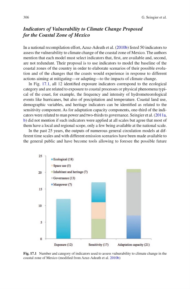
In Fig. 17.1, all 12 identified exposure indicators correspond to the ecological
category and are related to exposure to coastal processes or physical phenomena typical of the coast, for example, the frequency and intensity of hydrometeorological
events like hurricanes, but also of precipitation and temperature. Coastal land use,
demographic variables, and heritage indicators can be identified as related to the
sensitivity component. As for adaptation capacity components, one-third of the indicators were related to man power and two-thirds to governance. Seingier et al. (2011a,
b) did not mention if such indicators were applied at all scales but agree that most of
them have a local and regional scope, only a few being available at the national scale.
In the past 25 years, the outputs of numerous general circulation models at different time scales and with different emission scenarios have been made available to
the general public and have become tools allowing to foresee the possible future
Fig. 17.1 Number and category of indicators used to assess vulnerability to climate change in the
coastal zone of Mexico (modified from Azuz-Adeath et al. 2010b)
G. Seingier et al.
Indicators of Vulnerability to Climate Change Proposed
for the Coastal Zone of Mexico
In a national recompilation effort, Azuz-Adeath et al. (2010b) listed 50 indicators to
assess the vulnerability to climate change of the coastal zone of Mexico. The authors
mention that each model must select indicators that, first, are available and, second,
are not redundant. Their proposal is to use indicators to model the baseline of the
coastal zones of the country in order to elaborate scenarios of their possible evolution and of the changes that the coasts would experience in response to different
actions aiming at mitigating—or adapting—to the impacts of climate change.
In Fig. 17.1, all 12 identified exposure indicators correspond to the ecological
category and are related to exposure to coastal processes or physical phenomena typical of the coast, for example, the frequency and intensity of hydrometeorological
events like hurricanes, but also of precipitation and temperature. Coastal land use,
demographic variables, and heritage indicators can be identified as related to the
sensitivity component. As for adaptation capacity components, one-third of the indicators were related to man power and two-thirds to governance. Seingier et al. (2011a,
b) did not mention if such indicators were applied at all scales but agree that most of
them have a local and regional scope, only a few being available at the national scale.
In the past 25 years, the outputs of numerous general circulation models at different time scales and with different emission scenarios have been made available to
the general public and have become tools allowing to foresee the possible future
Fig. 17.1 Number and category of indicators used to assess vulnerability to climate change in the
coastal zone of Mexico (modified from Azuz-Adeath et al. 2010b)
G. Seingier et al.