

289
The multiple land categories of the original TUC and RAN polygons were
reclassified into two: communal and non-communal lands, and then merged with
the boundary outline of Mexico to create two binary polygon files, each with two
categories. The two potential outcomes for each file were COMUNAL_RAN or
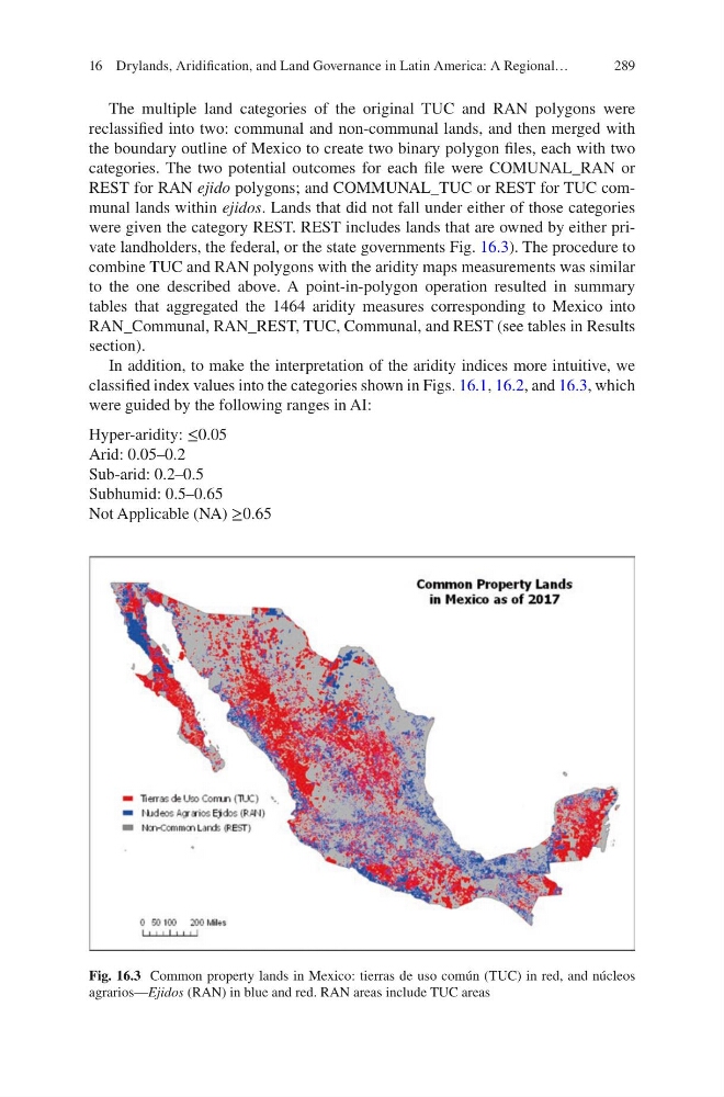
REST for RAN ejido polygons; and COMMUNAL_TUC or REST for TUC communal lands within ejidos. Lands that did not fall under either of those categories
were given the category REST. REST includes lands that are owned by either private landholders, the federal, or the state governments Fig. 16.3). The procedure to
combine TUC and RAN polygons with the aridity maps measurements was similar
to the one described above. A point-in-polygon operation resulted in summary
tables that aggregated the 1464 aridity measures corresponding to Mexico into
RAN_Communal, RAN_REST, TUC, Communal, and REST (see tables in Results
section).
In addition, to make the interpretation of the aridity indices more intuitive, we
classified index values into the categories shown in Figs. 16.1, 16.2, and 16.3, which
were guided by the following ranges in AI:
Hyper-aridity: ≤0.05
Arid: 0.05–0.2
Sub-arid: 0.2–0.5
Subhumid: 0.5–0.65
Not Applicable (NA) ≥0.65
Fig. 16.3 Common property lands in Mexico: tierras de uso común (TUC) in red, and núcleos
agrarios—Ejidos (RAN) in blue and red. RAN areas include TUC areas
16 Drylands, Aridification, and Land Governance in Latin America: A Regional…
The multiple land categories of the original TUC and RAN polygons were
reclassified into two: communal and non-communal lands, and then merged with
the boundary outline of Mexico to create two binary polygon files, each with two
categories. The two potential outcomes for each file were COMUNAL_RAN or
REST for RAN ejido polygons; and COMMUNAL_TUC or REST for TUC communal lands within ejidos. Lands that did not fall under either of those categories
were given the category REST. REST includes lands that are owned by either private landholders, the federal, or the state governments Fig. 16.3). The procedure to
combine TUC and RAN polygons with the aridity maps measurements was similar
to the one described above. A point-in-polygon operation resulted in summary
tables that aggregated the 1464 aridity measures corresponding to Mexico into
RAN_Communal, RAN_REST, TUC, Communal, and REST (see tables in Results
section).
In addition, to make the interpretation of the aridity indices more intuitive, we
classified index values into the categories shown in Figs. 16.1, 16.2, and 16.3, which
were guided by the following ranges in AI:
Hyper-aridity: ≤0.05
Arid: 0.05–0.2
Sub-arid: 0.2–0.5
Subhumid: 0.5–0.65
Not Applicable (NA) ≥0.65
Fig. 16.3 Common property lands in Mexico: tierras de uso común (TUC) in red, and núcleos
agrarios—Ejidos (RAN) in blue and red. RAN areas include TUC areas
16 Drylands, Aridification, and Land Governance in Latin America: A Regional…