

540
Lake Victoria Basin supports a rapidly growing population currently estimated at
over 35 million, with average population growth rates in the Basin of approximately
3% per year (UNEP 2006). Population density in the Basin is one of the highest in
the world; average population density on the Kenyan, Tanzanian, and Ugandan
sides of the Basin is 297 persons per km
2
, 97 persons per km
2
, and 635 persons
per km
2
, respectively. The Basin-wide average population density rate is 155 persons per km
2
(ILEC 2005). A map depicting the distribution of population density
in Lake Victoria Basin is presented below in Fig. 19.6.
19.4.2 Watershed Issues at the Food–Energy–Water Nexus
The Lake Victoria Basin is an important source of fish and freshwater for domestic
consumption and agricultural production. The catchment areas of the Lake serve as
sinks for agricultural, domestic, and industrial runoff of numerous effluents and
residues, which pose a threat to the habitat of fish species. The scientific value of
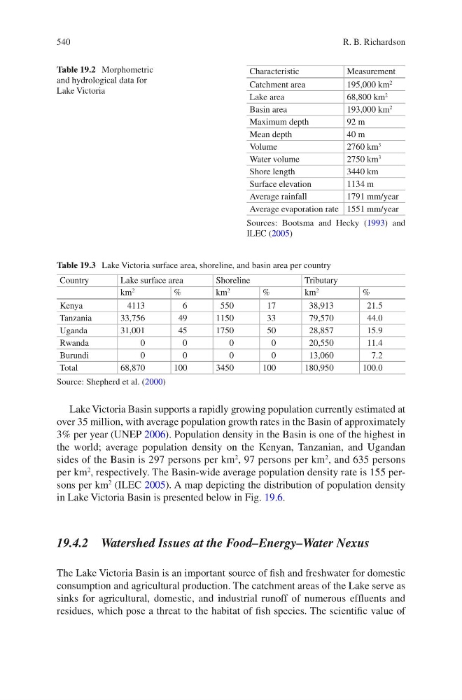
Table 19.2 Morphometric
and hydrological data for
Lake Victoria
Characteristic
Measurement
Catchment area
195,000 km
2
Lake area
68,800 km
2
Basin area
193,000 km
2
Maximum depth
92 m
Mean depth
40 m
Volume
2760 km
3
Water volume
2750 km
3
Shore length
3440 km
Surface elevation
1134 m
Average rainfall
1791 mm/year
Average evaporation rate 1551 mm/year
Sources: Bootsma and Hecky (1993) and
ILEC (2005)
Table 19.3 Lake Victoria surface area, shoreline, and basin area per country
Country
Lake surface area
Shoreline
Tributary
km
2
%
km
2
%
km
2
%
Kenya
4113
6
550
17
38,913
21.5
Tanzania
33,756
49
1150
33
79,570
44.0
Uganda
31,001
45
1750
50
28,857
15.9
Rwanda
0
0
0
0
20,550
11.4
Burundi
0
0
0
0
13,060
7.2
Total
68,870
100
3450
100
180,950
100.0
Source: Shepherd et al. (2000)
R. B. Richardson
Lake Victoria Basin supports a rapidly growing population currently estimated at
over 35 million, with average population growth rates in the Basin of approximately
3% per year (UNEP 2006). Population density in the Basin is one of the highest in
the world; average population density on the Kenyan, Tanzanian, and Ugandan
sides of the Basin is 297 persons per km
2
, 97 persons per km
2
, and 635 persons
per km
2
, respectively. The Basin-wide average population density rate is 155 persons per km
2
(ILEC 2005). A map depicting the distribution of population density
in Lake Victoria Basin is presented below in Fig. 19.6.
19.4.2 Watershed Issues at the Food–Energy–Water Nexus
The Lake Victoria Basin is an important source of fish and freshwater for domestic
consumption and agricultural production. The catchment areas of the Lake serve as
sinks for agricultural, domestic, and industrial runoff of numerous effluents and
residues, which pose a threat to the habitat of fish species. The scientific value of
Table 19.2 Morphometric
and hydrological data for
Lake Victoria
Characteristic
Measurement
Catchment area
195,000 km
2
Lake area
68,800 km
2
Basin area
193,000 km
2
Maximum depth
92 m
Mean depth
40 m
Volume
2760 km
3
Water volume
2750 km
3
Shore length
3440 km
Surface elevation
1134 m
Average rainfall
1791 mm/year
Average evaporation rate 1551 mm/year
Sources: Bootsma and Hecky (1993) and
ILEC (2005)
Table 19.3 Lake Victoria surface area, shoreline, and basin area per country
Country
Lake surface area
Shoreline
Tributary
km
2
%
km
2
%
km
2
%
Kenya
4113
6
550
17
38,913
21.5
Tanzania
33,756
49
1150
33
79,570
44.0
Uganda
31,001
45
1750
50
28,857
15.9
Rwanda
0
0
0
0
20,550
11.4
Burundi
0
0
0
0
13,060
7.2
Total
68,870
100
3450
100
180,950
100.0
Source: Shepherd et al. (2000)
R. B. Richardson