

539
19.4 Lake Victoria Basin in East Africa
19.4.1 Background
Lake Victoria is located in East Africa and is one of several freshwater lakes situated
along the Great Rift Valley. The shore of Lake Victoria borders Uganda, Kenya, and
Tanzania, and the Lake Victoria Basin also includes tributaries that flow from
Rwanda and Burundi. It is situated at an altitude of approximately 1134 m (ILEC
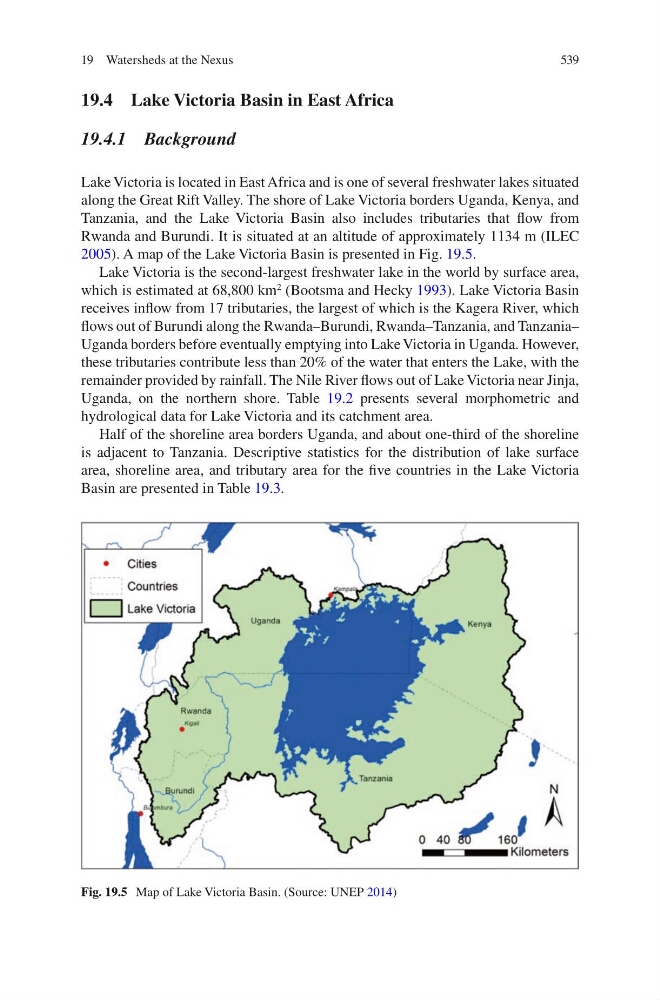
2005). A map of the Lake Victoria Basin is presented in Fig. 19.5.
Lake Victoria is the second-largest freshwater lake in the world by surface area,
which is estimated at 68,800 km
2
(Bootsma and Hecky 1993). Lake Victoria Basin
receives inflow from 17 tributaries, the largest of which is the Kagera River, which
flows out of Burundi along the Rwanda–Burundi, Rwanda–Tanzania, and Tanzania–
Uganda borders before eventually emptying into Lake Victoria in Uganda. However,
these tributaries contribute less than 20% of the water that enters the Lake, with the
remainder provided by rainfall. The Nile River flows out of Lake Victoria near Jinja,
Uganda, on the northern shore. Table 19.2 presents several morphometric and
hydrological data for Lake Victoria and its catchment area.
Half of the shoreline area borders Uganda, and about one-third of the shoreline
is adjacent to Tanzania. Descriptive statistics for the distribution of lake surface
area, shoreline area, and tributary area for the five countries in the Lake Victoria
Basin are presented in Table 19.3.
Fig. 19.5 Map of Lake Victoria Basin. (Source: UNEP 2014)
19 Watersheds at the Nexus
19.4 Lake Victoria Basin in East Africa
19.4.1 Background
Lake Victoria is located in East Africa and is one of several freshwater lakes situated
along the Great Rift Valley. The shore of Lake Victoria borders Uganda, Kenya, and
Tanzania, and the Lake Victoria Basin also includes tributaries that flow from
Rwanda and Burundi. It is situated at an altitude of approximately 1134 m (ILEC
2005). A map of the Lake Victoria Basin is presented in Fig. 19.5.
Lake Victoria is the second-largest freshwater lake in the world by surface area,
which is estimated at 68,800 km
2
(Bootsma and Hecky 1993). Lake Victoria Basin
receives inflow from 17 tributaries, the largest of which is the Kagera River, which
flows out of Burundi along the Rwanda–Burundi, Rwanda–Tanzania, and Tanzania–
Uganda borders before eventually emptying into Lake Victoria in Uganda. However,
these tributaries contribute less than 20% of the water that enters the Lake, with the
remainder provided by rainfall. The Nile River flows out of Lake Victoria near Jinja,
Uganda, on the northern shore. Table 19.2 presents several morphometric and
hydrological data for Lake Victoria and its catchment area.
Half of the shoreline area borders Uganda, and about one-third of the shoreline
is adjacent to Tanzania. Descriptive statistics for the distribution of lake surface
area, shoreline area, and tributary area for the five countries in the Lake Victoria
Basin are presented in Table 19.3.
Fig. 19.5 Map of Lake Victoria Basin. (Source: UNEP 2014)
19 Watersheds at the Nexus