

155
• overstressed,
• variable stress,
• human dominated stress,
• unstressed.
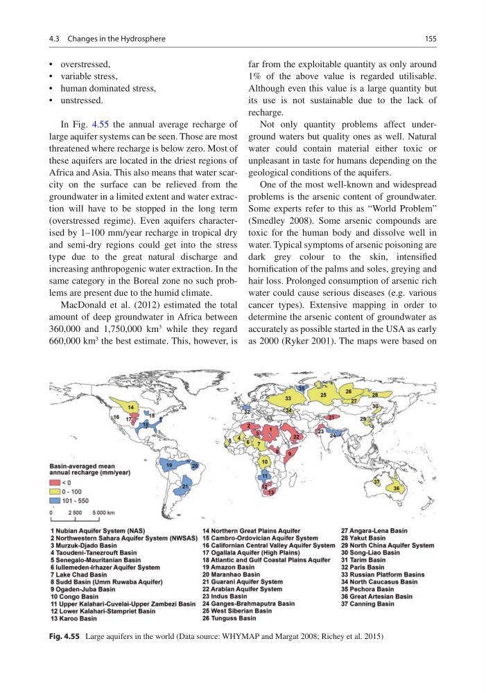
In Fig. 4.55 the annual average recharge of
large aquifer systems can be seen. Those are most
threatened where recharge is below zero. Most of
these aquifers are located in the driest regions of
Africa and Asia. This also means that water scarcity on the surface can be relieved from the
groundwater in a limited extent and water extraction will have to be stopped in the long term
(overstressed regime). Even aquifers characterised by 1–100 mm/year recharge in tropical dry
and semi-dry regions could get into the stress
type due to the great natural discharge and
increasing anthropogenic water extraction. In the
same category in the Boreal zone no such problems are present due to the humid climate.
MacDonald et al. (2012) estimated the total
amount of deep groundwater in Africa between
360,000 and 1,750,000 km
3
while they regard
660,000 km
3
the best estimate. This, however, is
far from the exploitable quantity as only around
1% of the above value is regarded utilisable.
Although even this value is a large quantity but
its use is not sustainable due to the lack of
recharge.
Not only quantity problems affect underground waters but quality ones as well. Natural
water could contain material either toxic or
unpleasant in taste for humans depending on the
geological conditions of the aquifers.
One of the most well-known and widespread
problems is the arsenic content of groundwater.
Some experts refer to this as “World Problem”
(Smedley 2008). Some arsenic compounds are
toxic for the human body and dissolve well in
water. Typical symptoms of arsenic poisoning are
dark grey colour to the skin, intensified
hornification of the palms and soles, greying and
hair loss. Prolonged consumption of arsenic rich
water could cause serious diseases (e.g. various
cancer types). Extensive mapping in order to
determine the arsenic content of groundwater as
accurately as possible started in the USA as early
as 2000 (Ryker 2001). The maps were based on
Fig. 4.55 Large aquifers in the world (Data source: WHYMAP and Margat 2008; Richey et al. 2015)
4.3 Changes in the Hydrosphere
• overstressed,
• variable stress,
• human dominated stress,
• unstressed.
In Fig. 4.55 the annual average recharge of
large aquifer systems can be seen. Those are most
threatened where recharge is below zero. Most of
these aquifers are located in the driest regions of
Africa and Asia. This also means that water scarcity on the surface can be relieved from the
groundwater in a limited extent and water extraction will have to be stopped in the long term
(overstressed regime). Even aquifers characterised by 1–100 mm/year recharge in tropical dry
and semi-dry regions could get into the stress
type due to the great natural discharge and
increasing anthropogenic water extraction. In the
same category in the Boreal zone no such problems are present due to the humid climate.
MacDonald et al. (2012) estimated the total
amount of deep groundwater in Africa between
360,000 and 1,750,000 km
3
while they regard
660,000 km
3
the best estimate. This, however, is
far from the exploitable quantity as only around
1% of the above value is regarded utilisable.
Although even this value is a large quantity but
its use is not sustainable due to the lack of
recharge.
Not only quantity problems affect underground waters but quality ones as well. Natural
water could contain material either toxic or
unpleasant in taste for humans depending on the
geological conditions of the aquifers.
One of the most well-known and widespread
problems is the arsenic content of groundwater.
Some experts refer to this as “World Problem”
(Smedley 2008). Some arsenic compounds are
toxic for the human body and dissolve well in
water. Typical symptoms of arsenic poisoning are
dark grey colour to the skin, intensified
hornification of the palms and soles, greying and
hair loss. Prolonged consumption of arsenic rich
water could cause serious diseases (e.g. various
cancer types). Extensive mapping in order to
determine the arsenic content of groundwater as
accurately as possible started in the USA as early
as 2000 (Ryker 2001). The maps were based on
Fig. 4.55 Large aquifers in the world (Data source: WHYMAP and Margat 2008; Richey et al. 2015)
4.3 Changes in the Hydrosphere