

2.7.1 Case Study 1: LNAPL Recovery
An oil spill occurred on a lamination plant located in a valley in central France.
Piezometric monitoring devices detected an increase in hydrocarbon concentrations.
The geological context is as follows: Bajocian and lower Bathonian limestones
(Dogger limestones) are cut through by valleys which go down to a bedrock of
Liassic marls, on top of which lies modern alluvium. The lamination plant is located
on this 12-m thick alluvium.
Below the site is an unconfined aquifer with interstitial porosity made of sandy
clayey limestone gravel. One could observe a geological heterogeneity: from gravelly levels in the thin layers to clayey lenses in the thicker layers. The plant is located
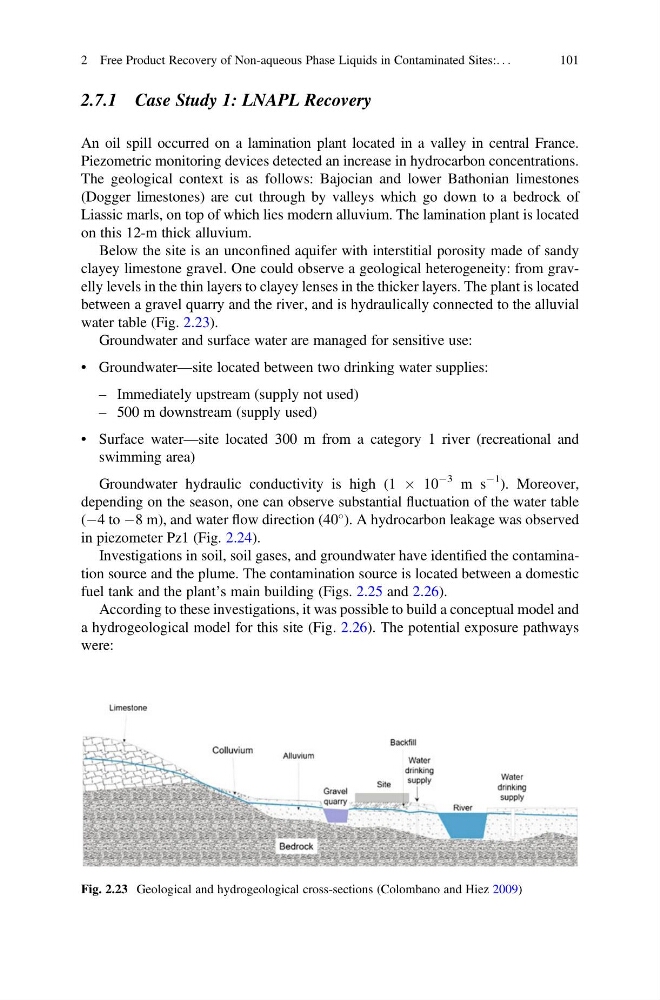
between a gravel quarry and the river, and is hydraulically connected to the alluvial
water table (Fig. 2.23).
Groundwater and surface water are managed for sensitive use:
• Groundwater—site located between two drinking water supplies:
– Immediately upstream (supply not used)
– 500 m downstream (supply used)
• Surface water—site located 300 m from a category 1 river (recreational and
swimming area)
Groundwater hydraulic conductivity is high (1 Â 10
À3 m s
À1 ). Moreover,
depending on the season, one can observe substantial fluctuation of the water table
(À4 to À8 m), and water flow direction (40
). A hydrocarbon leakage was observed
in piezometer Pz1 (Fig. 2.24).
Investigations in soil, soil gases, and groundwater have identified the contamination source and the plume. The contamination source is located between a domestic
fuel tank and the plant’s main building (Figs. 2.25 and 2.26).
According to these investigations, it was possible to build a conceptual model and
a hydrogeological model for this site (Fig. 2.26). The potential exposure pathways
were:
Fig. 2.23 Geological and hydrogeological cross-sections (Colombano and Hiez 2009)
2 Free Product Recovery of Non-aqueous Phase Liquids in Contaminated Sites:. . .
101
An oil spill occurred on a lamination plant located in a valley in central France.
Piezometric monitoring devices detected an increase in hydrocarbon concentrations.
The geological context is as follows: Bajocian and lower Bathonian limestones
(Dogger limestones) are cut through by valleys which go down to a bedrock of
Liassic marls, on top of which lies modern alluvium. The lamination plant is located
on this 12-m thick alluvium.
Below the site is an unconfined aquifer with interstitial porosity made of sandy
clayey limestone gravel. One could observe a geological heterogeneity: from gravelly levels in the thin layers to clayey lenses in the thicker layers. The plant is located
between a gravel quarry and the river, and is hydraulically connected to the alluvial
water table (Fig. 2.23).
Groundwater and surface water are managed for sensitive use:
• Groundwater—site located between two drinking water supplies:
– Immediately upstream (supply not used)
– 500 m downstream (supply used)
• Surface water—site located 300 m from a category 1 river (recreational and
swimming area)
Groundwater hydraulic conductivity is high (1 Â 10
À3 m s
À1 ). Moreover,
depending on the season, one can observe substantial fluctuation of the water table
(À4 to À8 m), and water flow direction (40
). A hydrocarbon leakage was observed
in piezometer Pz1 (Fig. 2.24).
Investigations in soil, soil gases, and groundwater have identified the contamination source and the plume. The contamination source is located between a domestic
fuel tank and the plant’s main building (Figs. 2.25 and 2.26).
According to these investigations, it was possible to build a conceptual model and
a hydrogeological model for this site (Fig. 2.26). The potential exposure pathways
were:
Fig. 2.23 Geological and hydrogeological cross-sections (Colombano and Hiez 2009)
2 Free Product Recovery of Non-aqueous Phase Liquids in Contaminated Sites:. . .
101