

climates (see rainfall in Fig. 9.2b), (b) semi-deciduous forests under moist and
seasonal climates (Fayolle et al. 2014a), (c) a transition type generally recognized
in between the previous two types (De Namur 1990). Similarly, savannas can be
divided into several types based on physiognomy, from woodlands to grass savannas
(Aubréville 1957), or based on tree species composition (Fayolle et al. 2019;
Osborne et al. 2018).
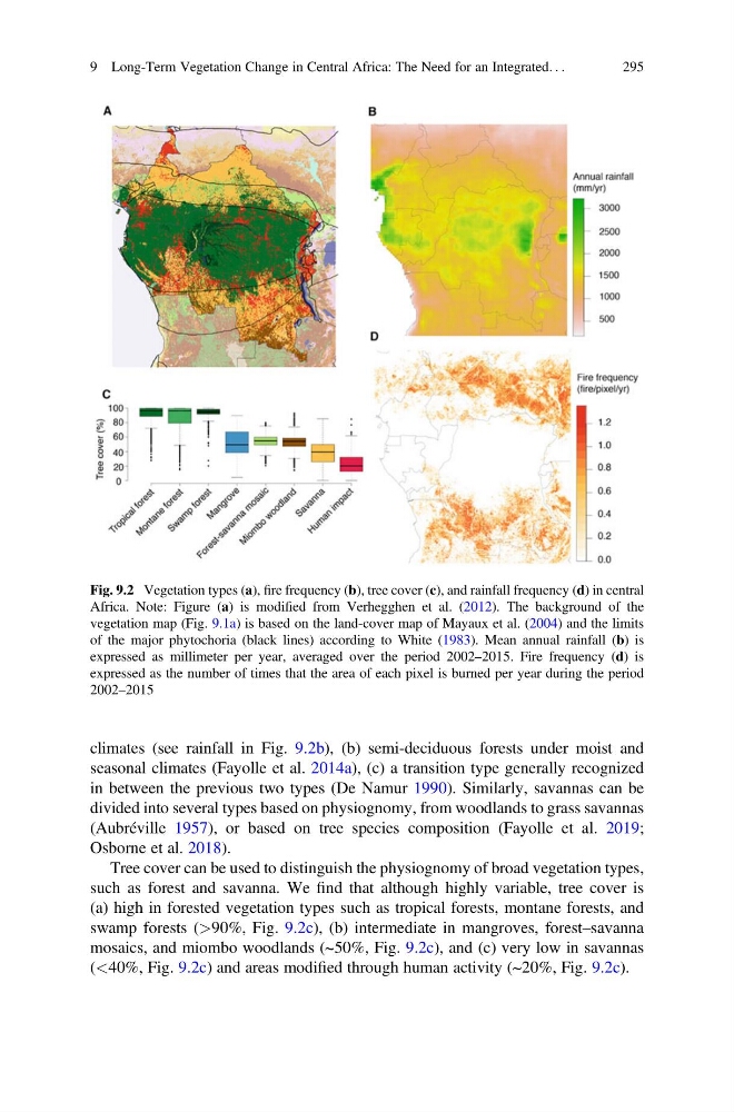
Tree cover can be used to distinguish the physiognomy of broad vegetation types,
such as forest and savanna. We find that although highly variable, tree cover is
(a) high in forested vegetation types such as tropical forests, montane forests, and
swamp forests (>90%, Fig. 9.2c), (b) intermediate in mangroves, forest–savanna
mosaics, and miombo woodlands (~50%, Fig. 9.2c), and (c) very low in savannas
(<40%, Fig. 9.2c) and areas modified through human activity (~20%, Fig. 9.2c).
Fig. 9.2 Vegetation types (a), fire frequency (b), tree cover (c), and rainfall frequency (d) in central
Africa. Note: Figure (a) is modified from Verhegghen et al. (2012). The background of the
vegetation map (Fig. 9.1a) is based on the land-cover map of Mayaux et al. (2004) and the limits
of the major phytochoria (black lines) according to White (1983). Mean annual rainfall (b) is
expressed as millimeter per year, averaged over the period 2002–2015. Fire frequency (d) is
expressed as the number of times that the area of each pixel is burned per year during the period
2002–2015
9 Long-Term Vegetation Change in Central Africa: The Need for an Integrated. . .
295
seasonal climates (Fayolle et al. 2014a), (c) a transition type generally recognized
in between the previous two types (De Namur 1990). Similarly, savannas can be
divided into several types based on physiognomy, from woodlands to grass savannas
(Aubréville 1957), or based on tree species composition (Fayolle et al. 2019;
Osborne et al. 2018).
Tree cover can be used to distinguish the physiognomy of broad vegetation types,
such as forest and savanna. We find that although highly variable, tree cover is
(a) high in forested vegetation types such as tropical forests, montane forests, and
swamp forests (>90%, Fig. 9.2c), (b) intermediate in mangroves, forest–savanna
mosaics, and miombo woodlands (~50%, Fig. 9.2c), and (c) very low in savannas
(<40%, Fig. 9.2c) and areas modified through human activity (~20%, Fig. 9.2c).
Fig. 9.2 Vegetation types (a), fire frequency (b), tree cover (c), and rainfall frequency (d) in central
Africa. Note: Figure (a) is modified from Verhegghen et al. (2012). The background of the
vegetation map (Fig. 9.1a) is based on the land-cover map of Mayaux et al. (2004) and the limits
of the major phytochoria (black lines) according to White (1983). Mean annual rainfall (b) is
expressed as millimeter per year, averaged over the period 2002–2015. Fire frequency (d) is
expressed as the number of times that the area of each pixel is burned per year during the period
2002–2015
9 Long-Term Vegetation Change in Central Africa: The Need for an Integrated. . .
295