

333
developed, and particularly the 2021 BIOMASS P-band InSAR mission (Le Toan
et al. 2011) will provide consistent means for global biomass mapping and
monitoring.
13.3 Conclusion and Further Work
Traits, drivers, and effects on biodiversity exist on all spatiotemporal scales. Airand spaceborne RS data capture processes and patterns in ecosystems, but often
without the knowledge of the cause of the phenomenon and real high-frequency
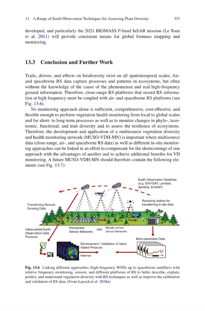
ground information. Therefore, close-range RS platforms that record RS information at high frequency must be coupled with air- and spaceborne RS platforms (see
Fig. 13.6).
No monitoring approach alone is sufficient, comprehensive, cost-effective, and
flexible enough to perform vegetation health monitoring from local to global scales
and for short- to long-term processes as well as to monitor changes in phylo-, taxonomic, functional, and trait diversity and to assess the resilience of ecosystems.
Therefore, the development and application of a multisource vegetation diversity
and health monitoring network (MUSO-VDH-MN) is important where multisource
data (close-range, air-, and spaceborne RS data) as well as different in-situ monitoring approaches can be linked in an effort to compensate for the shortcomings of one
approach with the advantages of another and to achieve additional benefits for VH
monitoring. A future MUSO-VDH-MN should therefore contain the following elements (see Fig. 13.7):
Permanent
Sensor Networks
Earth Observation Satellites
(e.g. ENVISAT, Landsat,
Sentinel, EnMAP)
Receiving station for
transferring in-situ data
Transferring Remote
Sensing Data
Value-added Earth
Observation Data
Products
Development / Validation of Value
Added Products
Internet
Multi-parameter Data
Mobile ad-hoc
Sensor Networks
AND
e
Fig. 13.6 Linking different approaches (high-frequency WSNs up to spaceborne satellites) with
relative frequency monitoring, sensors, and different platforms of RS to better describe, explain,
predict, and understand vegetation diversity with RS techniques as well as improve the calibration
and validation of RS data. (From Lausch et al. 2018a)
13 A Range of Earth Observation Techniques for Assessing Plant Diversity
developed, and particularly the 2021 BIOMASS P-band InSAR mission (Le Toan
et al. 2011) will provide consistent means for global biomass mapping and
monitoring.
13.3 Conclusion and Further Work
Traits, drivers, and effects on biodiversity exist on all spatiotemporal scales. Airand spaceborne RS data capture processes and patterns in ecosystems, but often
without the knowledge of the cause of the phenomenon and real high-frequency
ground information. Therefore, close-range RS platforms that record RS information at high frequency must be coupled with air- and spaceborne RS platforms (see
Fig. 13.6).
No monitoring approach alone is sufficient, comprehensive, cost-effective, and
flexible enough to perform vegetation health monitoring from local to global scales
and for short- to long-term processes as well as to monitor changes in phylo-, taxonomic, functional, and trait diversity and to assess the resilience of ecosystems.
Therefore, the development and application of a multisource vegetation diversity
and health monitoring network (MUSO-VDH-MN) is important where multisource
data (close-range, air-, and spaceborne RS data) as well as different in-situ monitoring approaches can be linked in an effort to compensate for the shortcomings of one
approach with the advantages of another and to achieve additional benefits for VH
monitoring. A future MUSO-VDH-MN should therefore contain the following elements (see Fig. 13.7):
Permanent
Sensor Networks
Earth Observation Satellites
(e.g. ENVISAT, Landsat,
Sentinel, EnMAP)
Receiving station for
transferring in-situ data
Transferring Remote
Sensing Data
Value-added Earth
Observation Data
Products
Development / Validation of Value
Added Products
Internet
Multi-parameter Data
Mobile ad-hoc
Sensor Networks
AND
e
Fig. 13.6 Linking different approaches (high-frequency WSNs up to spaceborne satellites) with
relative frequency monitoring, sensors, and different platforms of RS to better describe, explain,
predict, and understand vegetation diversity with RS techniques as well as improve the calibration
and validation of RS data. (From Lausch et al. 2018a)
13 A Range of Earth Observation Techniques for Assessing Plant Diversity