

221
(e.g., deforestation for industrial agriculture, thinning, and land clearings for livestock farming, selective logging, hunting and gathering). The rapid conversion of
native forests to annual crops and pastures makes the Chaco a global deforestation
hotspot (Hansen et al. 2013; Vallejos et al. 2015). This transformation brought an
increase in the production of commodities (i.e., crops, meat) for the foreign markets, which are relevant for the national economy. However, it is also compromising
the supply of multiple ecosystem services (Grau et al. 2005; Paruelo et al. 2011;
Mastrangelo and Laterra 2015), creating social inequalities (Sacchi and Gasparri
2015; Laterra et al. 2019) and increasing social conflicts (REDAF 2012; Cáceres
et al. 2015; Aguiar et al. 2017). Despite some legislation efforts (e.g., National Law
N° 26,331), the territorial configuration responds more to an economic rationality,
than to ecological, social and cultural criteria (Aguiar et al. 2017).
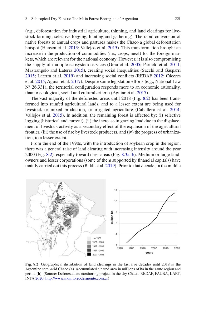
The vast majority of the deforested areas until 2018 (Fig. 8.2) has been transformed into rainfed agricultural lands, and to a lesser extent are being used for
livestock or mixed production, or irrigated agriculture (Caballero et al. 2014;
Vallejos et al. 2015). In addition, the remaining forest is affected by: (i) selective
logging (historical and current), (ii) the increase in grazing load due to the displacement of livestock activity as a secondary effect of the expansion of the agricultural
frontier, (iii) the use of fire by livestock producers, and (iv) the progress of urbanization, to a lesser extent.
From the end of the 1990s, with the introduction of soybean crop in the region,
there was a general raise of land clearing with increasing intensity around the year
2000 (Fig. 8.2), especially toward drier areas (Fig. 8.3a, b). Medium or large landowners and lesser corporations (some of them supported by financial capitals) have
mainly carried out this process (Baldi et al. 2019). Prior to that decade, in the middle
Fig. 8.2 Geographical distribution of land clearings in the last five decades until 2018 in the
Argentine semi-arid Chaco (a). Accumulated cleared area in millions of ha in the same region and
period (b). (Source: Deforestation monitoring project in the dry Chaco. REDAF, FAUBA, LART,
INTA 2020. http://www.monitoreodesmonte.com.ar)
8 Subtropical Dry Forests: The Main Forest Ecoregion of Argentina
(e.g., deforestation for industrial agriculture, thinning, and land clearings for livestock farming, selective logging, hunting and gathering). The rapid conversion of
native forests to annual crops and pastures makes the Chaco a global deforestation
hotspot (Hansen et al. 2013; Vallejos et al. 2015). This transformation brought an
increase in the production of commodities (i.e., crops, meat) for the foreign markets, which are relevant for the national economy. However, it is also compromising
the supply of multiple ecosystem services (Grau et al. 2005; Paruelo et al. 2011;
Mastrangelo and Laterra 2015), creating social inequalities (Sacchi and Gasparri
2015; Laterra et al. 2019) and increasing social conflicts (REDAF 2012; Cáceres
et al. 2015; Aguiar et al. 2017). Despite some legislation efforts (e.g., National Law
N° 26,331), the territorial configuration responds more to an economic rationality,
than to ecological, social and cultural criteria (Aguiar et al. 2017).
The vast majority of the deforested areas until 2018 (Fig. 8.2) has been transformed into rainfed agricultural lands, and to a lesser extent are being used for
livestock or mixed production, or irrigated agriculture (Caballero et al. 2014;
Vallejos et al. 2015). In addition, the remaining forest is affected by: (i) selective
logging (historical and current), (ii) the increase in grazing load due to the displacement of livestock activity as a secondary effect of the expansion of the agricultural
frontier, (iii) the use of fire by livestock producers, and (iv) the progress of urbanization, to a lesser extent.
From the end of the 1990s, with the introduction of soybean crop in the region,
there was a general raise of land clearing with increasing intensity around the year
2000 (Fig. 8.2), especially toward drier areas (Fig. 8.3a, b). Medium or large landowners and lesser corporations (some of them supported by financial capitals) have
mainly carried out this process (Baldi et al. 2019). Prior to that decade, in the middle
Fig. 8.2 Geographical distribution of land clearings in the last five decades until 2018 in the
Argentine semi-arid Chaco (a). Accumulated cleared area in millions of ha in the same region and
period (b). (Source: Deforestation monitoring project in the dry Chaco. REDAF, FAUBA, LART,
INTA 2020. http://www.monitoreodesmonte.com.ar)
8 Subtropical Dry Forests: The Main Forest Ecoregion of Argentina