

157
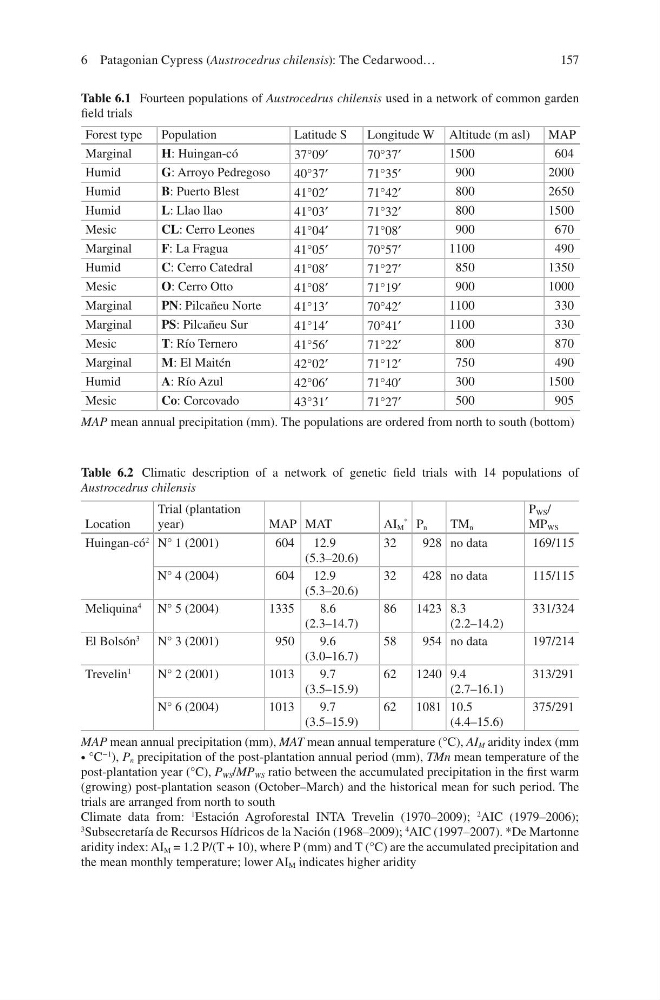
Table 6.1 Fourteen populations of Austrocedrus chilensis used in a network of common garden
field trials
Forest type
Population
Latitude S
Longitude W Altitude (m asl) MAP
Marginal
H: Huingan-có
37°09′
70°37′
1500
604
Humid
G: Arroyo Pedregoso
40°37′
71°35′
900
2000
Humid
B: Puerto Blest
41°02′
71°42′
800
2650
Humid
L: Llao llao
41°03′
71°32′
800
1500
Mesic
CL: Cerro Leones
41°04′
71°08′
900
670
Marginal
F: La Fragua
41°05′
70°57′
1100
490
Humid
C: Cerro Catedral
41°08′
71°27′
850
1350
Mesic
O: Cerro Otto
41°08′
71°19′
900
1000
Marginal
PN: Pilcañeu Norte
41°13′
70°42′
1100
330
Marginal
PS: Pilcañeu Sur
41°14′
70°41′
1100
330
Mesic
T: Río Ternero
41°56′
71°22′
800
870
Marginal
M: El Maitén
42°02′
71°12′
750
490
Humid
A: Río Azul
42°06′
71°40′
300
1500
Mesic
Co: Corcovado
43°31′
71°27′
500
905
MAP mean annual precipitation (mm). The populations are ordered from north to south (bottom)
Table 6.2 Climatic description of a network of genetic field trials with 14 populations of
Austrocedrus chilensis
Location
Trial (plantation
year)
MAP MAT
AI M
* P n
TM n
P WS /
MP WS
Huingan-có
2 N° 1 (2001)
604 12.9
(5.3–20.6)
32
928 no data
169/115
N° 4 (2004)
604 12.9
(5.3–20.6)
32
428 no data
115/115
Meliquina
4
N° 5 (2004)
1335
8.6
(2.3–14.7)
86
1423 8.3
(2.2–14.2)
331/324
El Bolsón
3
N° 3 (2001)
950
9.6
(3.0–16.7)
58
954 no data
197/214
Trevelin
1
N° 2 (2001)
1013
9.7
(3.5–15.9)
62
1240 9.4
(2.7–16.1)
313/291
N° 6 (2004)
1013
9.7
(3.5–15.9)
62
1081 10.5
(4.4–15.6)
375/291
MAP mean annual precipitation (mm), MAT mean annual temperature (°C), AI M aridity index (mm
∙ °C
−1
), P n precipitation of the post-plantation annual period (mm), TMn mean temperature of the
post-plantation year (°C), P WS /MP WS ratio between the accumulated precipitation in the first warm
(growing) post-plantation season (October–March) and the historical mean for such period. The
trials are arranged from north to south
Climate data from:
1 Estación Agroforestal INTA Trevelin (1970–2009);
2 AIC (1979–2006);
3
Subsecretaría de Recursos Hídricos de la Nación (1968–2009);
4
AIC (1997–2007). *De Martonne
aridity index: AI M = 1.2 P/(T + 10), where P (mm) and T (°C) are the accumulated precipitation and
the mean monthly temperature; lower AI M indicates higher aridity
6 Patagonian Cypress (Austrocedrus chilensis): The Cedarwood…
Table 6.1 Fourteen populations of Austrocedrus chilensis used in a network of common garden
field trials
Forest type
Population
Latitude S
Longitude W Altitude (m asl) MAP
Marginal
H: Huingan-có
37°09′
70°37′
1500
604
Humid
G: Arroyo Pedregoso
40°37′
71°35′
900
2000
Humid
B: Puerto Blest
41°02′
71°42′
800
2650
Humid
L: Llao llao
41°03′
71°32′
800
1500
Mesic
CL: Cerro Leones
41°04′
71°08′
900
670
Marginal
F: La Fragua
41°05′
70°57′
1100
490
Humid
C: Cerro Catedral
41°08′
71°27′
850
1350
Mesic
O: Cerro Otto
41°08′
71°19′
900
1000
Marginal
PN: Pilcañeu Norte
41°13′
70°42′
1100
330
Marginal
PS: Pilcañeu Sur
41°14′
70°41′
1100
330
Mesic
T: Río Ternero
41°56′
71°22′
800
870
Marginal
M: El Maitén
42°02′
71°12′
750
490
Humid
A: Río Azul
42°06′
71°40′
300
1500
Mesic
Co: Corcovado
43°31′
71°27′
500
905
MAP mean annual precipitation (mm). The populations are ordered from north to south (bottom)
Table 6.2 Climatic description of a network of genetic field trials with 14 populations of
Austrocedrus chilensis
Location
Trial (plantation
year)
MAP MAT
AI M
* P n
TM n
P WS /
MP WS
Huingan-có
2 N° 1 (2001)
604 12.9
(5.3–20.6)
32
928 no data
169/115
N° 4 (2004)
604 12.9
(5.3–20.6)
32
428 no data
115/115
Meliquina
4
N° 5 (2004)
1335
8.6
(2.3–14.7)
86
1423 8.3
(2.2–14.2)
331/324
El Bolsón
3
N° 3 (2001)
950
9.6
(3.0–16.7)
58
954 no data
197/214
Trevelin
1
N° 2 (2001)
1013
9.7
(3.5–15.9)
62
1240 9.4
(2.7–16.1)
313/291
N° 6 (2004)
1013
9.7
(3.5–15.9)
62
1081 10.5
(4.4–15.6)
375/291
MAP mean annual precipitation (mm), MAT mean annual temperature (°C), AI M aridity index (mm
∙ °C
−1
), P n precipitation of the post-plantation annual period (mm), TMn mean temperature of the
post-plantation year (°C), P WS /MP WS ratio between the accumulated precipitation in the first warm
(growing) post-plantation season (October–March) and the historical mean for such period. The
trials are arranged from north to south
Climate data from:
1 Estación Agroforestal INTA Trevelin (1970–2009);
2 AIC (1979–2006);
3
Subsecretaría de Recursos Hídricos de la Nación (1968–2009);
4
AIC (1997–2007). *De Martonne
aridity index: AI M = 1.2 P/(T + 10), where P (mm) and T (°C) are the accumulated precipitation and
the mean monthly temperature; lower AI M indicates higher aridity
6 Patagonian Cypress (Austrocedrus chilensis): The Cedarwood…