

Variety: Since a huge volume of remotely sensed data was generated by different
sources with different resolutions in multitemporal, variety is also a key factor in
big data remote sensing. Earth observation data collected by remote sensing
approach can be classified in areas of application, or its property. Structured
agricultural image data are sorted with standard format such as HDF, HDF-EOS,
netCDF, GeoTIFF, JPEG2000, and OGC GML-Cov.
Velocity: Handling a huge volume of data with such growing velocity is also an
imperative task in agricultural image data management and analysis. The basic
velocity-related impact for analyzing and processing remote sensing data including data transferring rate, data processing rate, and data accessing rate (Nativi
et al. 2015).
6.5 Agro-Geoinformation Extraction from Image
Information extraction is the core operation in digital image processing. There are
many methods to extract and understand agricultural related information from
remotely sensed image data. This section mainly focuses on three commonly used
information extraction approaches in agro-geoinformatics including expert systembased agricultural information extraction, decision tree–based agricultural information extraction, and neural network-based agricultural information extraction.
6.5.1 Knowledge-Based Expert System
A knowledge-based expert system is a computer system which applies artificial
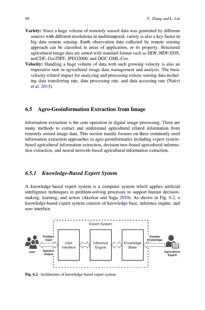
intelligence techniques in problem-solving processes to support human decisionmaking, learning, and action (Akerkar and Sajja 2010). As shown in Fig. 6.2, a
knowledge-based expert system consists of knowledge base, inference engine, and
user interface.
Fig. 6.2 Architecture of knowledge-based expert system
90
C. Zhang and L. Lin
sources with different resolutions in multitemporal, variety is also a key factor in
big data remote sensing. Earth observation data collected by remote sensing
approach can be classified in areas of application, or its property. Structured
agricultural image data are sorted with standard format such as HDF, HDF-EOS,
netCDF, GeoTIFF, JPEG2000, and OGC GML-Cov.
Velocity: Handling a huge volume of data with such growing velocity is also an
imperative task in agricultural image data management and analysis. The basic
velocity-related impact for analyzing and processing remote sensing data including data transferring rate, data processing rate, and data accessing rate (Nativi
et al. 2015).
6.5 Agro-Geoinformation Extraction from Image
Information extraction is the core operation in digital image processing. There are
many methods to extract and understand agricultural related information from
remotely sensed image data. This section mainly focuses on three commonly used
information extraction approaches in agro-geoinformatics including expert systembased agricultural information extraction, decision tree–based agricultural information extraction, and neural network-based agricultural information extraction.
6.5.1 Knowledge-Based Expert System
A knowledge-based expert system is a computer system which applies artificial
intelligence techniques in problem-solving processes to support human decisionmaking, learning, and action (Akerkar and Sajja 2010). As shown in Fig. 6.2, a
knowledge-based expert system consists of knowledge base, inference engine, and
user interface.
Fig. 6.2 Architecture of knowledge-based expert system
90
C. Zhang and L. Lin