

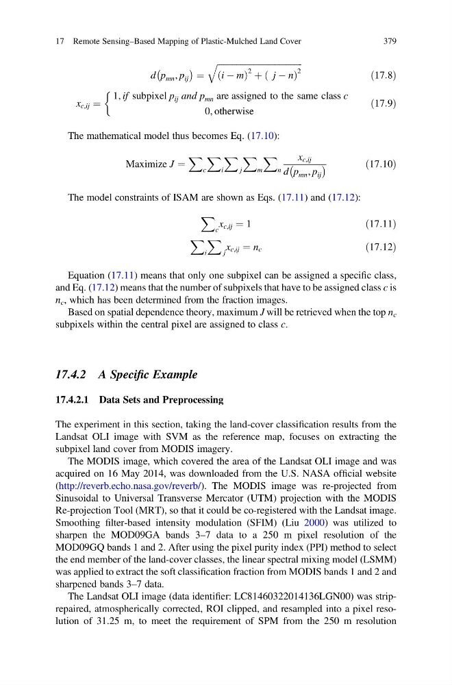
d p mn , p ij
À
Á ¼
ffiffiffiffiffiffiffiffiffiffiffiffiffiffiffiffiffiffiffiffiffiffiffiffiffiffiffiffiffiffiffiffiffiffiffiffiffiffiffi ffi
i À m
ð
Þ
2 þ j À n
ð
Þ
2
q
ð17:8Þ
x c,ij ¼
1, if subpixel p ij and p mn are assigned to the same class c
0, otherwise
&
ð17:9Þ
The mathematical model thus becomes Eq. (17.10):
Maximize J ¼
X
c
X
i
X
j
X
m
X
n
x c,ij
d p mn , p ij
À
Á
ð17:10Þ
The model constraints of ISAM are shown as Eqs. (17.11) and (17.12):
X
c
x c,ij ¼ 1
ð17:11Þ
X
i
X
j
x c,ij ¼ n c
ð17:12Þ
Equation (17.11) means that only one subpixel can be assigned a specific class,
and Eq. (17.12) means that the number of subpixels that have to be assigned class c is
n c , which has been determined from the fraction images.
Based on spatial dependence theory, maximum J will be retrieved when the top n c
subpixels within the central pixel are assigned to class c.
17.4.2 A Specific Example
17.4.2.1 Data Sets and Preprocessing
The experiment in this section, taking the land-cover classification results from the
Landsat OLI image with SVM as the reference map, focuses on extracting the
subpixel land cover from MODIS imagery.
The MODIS image, which covered the area of the Landsat OLI image and was
acquired on 16 May 2014, was downloaded from the U.S. NASA official website
(http://reverb.echo.nasa.gov/reverb/). The MODIS image was re-projected from
Sinusoidal to Universal Transverse Mercator (UTM) projection with the MODIS
Re-projection Tool (MRT), so that it could be co-registered with the Landsat image.
Smoothing filter-based intensity modulation (SFIM) (Liu 2000) was utilized to
sharpen the MOD09GA bands 3–7 data to a 250 m pixel resolution of the
MOD09GQ bands 1 and 2. After using the pixel purity index (PPI) method to select
the end member of the land-cover classes, the linear spectral mixing model (LSMM)
was applied to extract the soft classification fraction from MODIS bands 1 and 2 and
sharpened bands 3–7 data.
The Landsat OLI image (data identifier: LC81460322014136LGN00) was striprepaired, atmospherically corrected, ROI clipped, and resampled into a pixel resolution of 31.25 m, to meet the requirement of SPM from the 250 m resolution
17 Remote Sensing–Based Mapping of Plastic-Mulched Land Cover
379
À
Á ¼
ffiffiffiffiffiffiffiffiffiffiffiffiffiffiffiffiffiffiffiffiffiffiffiffiffiffiffiffiffiffiffiffiffiffiffiffiffiffiffi ffi
i À m
ð
Þ
2 þ j À n
ð
Þ
2
q
ð17:8Þ
x c,ij ¼
1, if subpixel p ij and p mn are assigned to the same class c
0, otherwise
&
ð17:9Þ
The mathematical model thus becomes Eq. (17.10):
Maximize J ¼
X
c
X
i
X
j
X
m
X
n
x c,ij
d p mn , p ij
À
Á
ð17:10Þ
The model constraints of ISAM are shown as Eqs. (17.11) and (17.12):
X
c
x c,ij ¼ 1
ð17:11Þ
X
i
X
j
x c,ij ¼ n c
ð17:12Þ
Equation (17.11) means that only one subpixel can be assigned a specific class,
and Eq. (17.12) means that the number of subpixels that have to be assigned class c is
n c , which has been determined from the fraction images.
Based on spatial dependence theory, maximum J will be retrieved when the top n c
subpixels within the central pixel are assigned to class c.
17.4.2 A Specific Example
17.4.2.1 Data Sets and Preprocessing
The experiment in this section, taking the land-cover classification results from the
Landsat OLI image with SVM as the reference map, focuses on extracting the
subpixel land cover from MODIS imagery.
The MODIS image, which covered the area of the Landsat OLI image and was
acquired on 16 May 2014, was downloaded from the U.S. NASA official website
(http://reverb.echo.nasa.gov/reverb/). The MODIS image was re-projected from
Sinusoidal to Universal Transverse Mercator (UTM) projection with the MODIS
Re-projection Tool (MRT), so that it could be co-registered with the Landsat image.
Smoothing filter-based intensity modulation (SFIM) (Liu 2000) was utilized to
sharpen the MOD09GA bands 3–7 data to a 250 m pixel resolution of the
MOD09GQ bands 1 and 2. After using the pixel purity index (PPI) method to select
the end member of the land-cover classes, the linear spectral mixing model (LSMM)
was applied to extract the soft classification fraction from MODIS bands 1 and 2 and
sharpened bands 3–7 data.
The Landsat OLI image (data identifier: LC81460322014136LGN00) was striprepaired, atmospherically corrected, ROI clipped, and resampled into a pixel resolution of 31.25 m, to meet the requirement of SPM from the 250 m resolution
17 Remote Sensing–Based Mapping of Plastic-Mulched Land Cover
379