

monitoring in many parts of the world. The use of SAR data might overcome this
problem, but the temporal resolutions of most radar missions are relatively low to
monitor these short-lived flood events. Some of the commercial SAR missions might
be able to provide SAR data with the fine temporal resolution, but flood monitoring
to a large extent is not financially practical compared with commercial data. Soil
Moisture Active Passive (SMAP) is the recent addition of an L-band radiometer
mission to observe the soil moisture with higher revisit capacity. SMAP data might
also be useful for agriculture flood monitoring with the possibility of crop damage at
root zone moisture saturation. Crops might get damage due to the soil moisture
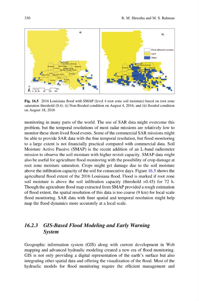
above the infiltration capacity of the soil for consecutive days. Figure 16.5 shows the
agricultural flood extent of the 2016 Louisiana flood. Flood is marked if root zone
soil moisture is above the soil infiltration capacity (threshold >0.45) for 72 h.
Though the agriculture flood map extracted from SMAP provided a rough estimation
of flood extent, the spatial resolution of this data is too coarse (9 km) for local scale
flood monitoring. SAR data with finer spatial and temporal resolution might help
map the flood dynamics more accurately at a local scale.
16.2.3 GIS-Based Flood Modeling and Early Warning
System
Geographic information system (GIS) along with current development in Web
mapping and advanced hydraulic modeling created a new era of flood monitoring.
GIS is not only providing a digital representation of the earth’s surface but also
integrating other spatial data and offering the visualization of the flood. Most of the
hydraulic models for flood monitoring require the efficient management and
Fig. 16.5 2016 Louisiana flood with SMAP (level 4 root zone soil moisture) based on root zone
saturation threshold (0.4). (i) Non-flooded condition on August 4, 2016, and (ii) flooded condition
on August 18, 2016
330
R. M. Shrestha and M. S. Rahman
problem, but the temporal resolutions of most radar missions are relatively low to
monitor these short-lived flood events. Some of the commercial SAR missions might
be able to provide SAR data with the fine temporal resolution, but flood monitoring
to a large extent is not financially practical compared with commercial data. Soil
Moisture Active Passive (SMAP) is the recent addition of an L-band radiometer
mission to observe the soil moisture with higher revisit capacity. SMAP data might
also be useful for agriculture flood monitoring with the possibility of crop damage at
root zone moisture saturation. Crops might get damage due to the soil moisture
above the infiltration capacity of the soil for consecutive days. Figure 16.5 shows the
agricultural flood extent of the 2016 Louisiana flood. Flood is marked if root zone
soil moisture is above the soil infiltration capacity (threshold >0.45) for 72 h.
Though the agriculture flood map extracted from SMAP provided a rough estimation
of flood extent, the spatial resolution of this data is too coarse (9 km) for local scale
flood monitoring. SAR data with finer spatial and temporal resolution might help
map the flood dynamics more accurately at a local scale.
16.2.3 GIS-Based Flood Modeling and Early Warning
System
Geographic information system (GIS) along with current development in Web
mapping and advanced hydraulic modeling created a new era of flood monitoring.
GIS is not only providing a digital representation of the earth’s surface but also
integrating other spatial data and offering the visualization of the flood. Most of the
hydraulic models for flood monitoring require the efficient management and
Fig. 16.5 2016 Louisiana flood with SMAP (level 4 root zone soil moisture) based on root zone
saturation threshold (0.4). (i) Non-flooded condition on August 4, 2016, and (ii) flooded condition
on August 18, 2016
330
R. M. Shrestha and M. S. Rahman